What to expect
Highlights
- The four cascades — Raja, Rani, Rover and Rocket.
- The sheer ~253 m drop of the Sharavathi.
- Viewpoints and the long stairway down towards the base.
Jog Falls is one of the highest plunge waterfalls in India, where the Sharavathi river hurls itself about 253 m off a sheer cliff on the border of Sagara and Siddapura taluks.

The fall splits into four streams with local names — Raja, Rani, Rover (the Roarer) and Rocket — and is at its thundering best in and just after the monsoon, when the Linganamakki dam releases water upstream.
Road km to Shivamogga; ghat roads and traffic vary — allow extra.
August to December for the fullest flow; the monsoon is dramatic but often mist-shrouded.
Live forecast loads in your browser.
Sun and moon are calculated for this location and shown in IST. Photography windows are the hour around sunrise and sunset; the sunset bearing is degrees clockwise from true north. Moon phase is accurate to about half a day.
Verified hotels, homestays, restaurants, experiences, sights, shops and rentals around Jog Falls — commission-free, with direct contact. Filter by what you need.
Verified places are being added. The category filters will fill in as approved stays, restaurants, experiences, sights, shops and nature listings go live.
List your place3 more places around Sagara. Open a guide to plan the visit and onward journey.

8.9 km · ~15 min by cab
A spread of islands and calm backwaters on the Sharavathi (Linganamakki) reservoir near Sagara — a long-running base for kayaking, coracle rides and camping amid forested shores.
22.0 km · ~37 min by cab
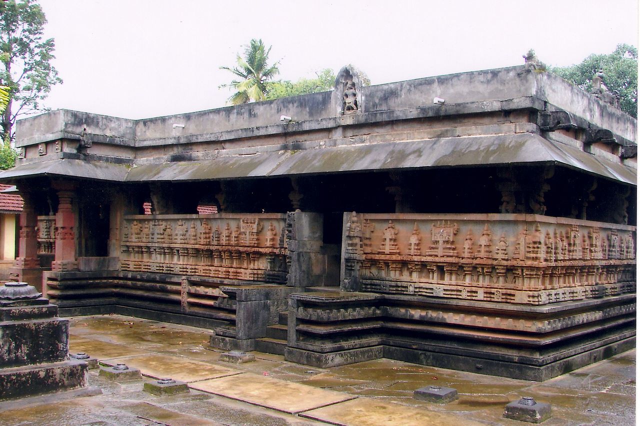
The 16th-century Rameshwara temple at Keladi, the first capital of the Keladi (Nayaka) dynasty, blends Hoysala, Dravidian and later styles with finely carved pillars; a small museum of Keladi history stands nearby.

25.0 km · ~42 min by cab
A large stone Shiva temple at Ikkeri, a later Keladi-Nayaka capital, built in a distinctive Vijayanagara–Hoysala hybrid style with a granite Nandi pavilion and carved outer walls.
Roampedia is commission-free — own or know a stay, eatery, guide or shop near Jog Falls? List it and it appears here once verified.
Add a nearby businessEntry: Small entry/parking fee
~30 km from Sagara, ~100 km from Shivamogga; viewpoints on both banks
If you are travelling by bus or ferry, check the return service with the operator before setting out. Leave time to reach the stop or jetty after your visit.
Ask at the bus stand for the time of the last service back, not the next one. If you miss it, an auto or app cab is the fallback — agree the fare before you get in.
If you need step-free access, contact the site before travelling. Ask about a level entrance, steps along the route, the nearest drop-off point, seating and accessible toilets.
Emergency numbers are verified against official government and state tourism sources. 112 works anywhere in India.
A spread of islands and calm backwaters on the Sharavathi (Linganamakki) reservoir near Sagara — a long-running base for kayaking, coracle rides and camping amid forested shores.
8.9 km · ~15 min by cab · straight lineThe 16th-century Rameshwara temple at Keladi, the first capital of the Keladi (Nayaka) dynasty, blends Hoysala, Dravidian and later styles with finely carved pillars; a small museum of Keladi history stands nearby.
22.0 km · ~37 min by cab · straight lineA large stone Shiva temple at Ikkeri, a later Keladi-Nayaka capital, built in a distinctive Vijayanagara–Hoysala hybrid style with a granite Nandi pavilion and carved outer walls.
25.0 km · ~42 min by cab · straight line
A forested peak of about 1,343 m in the Mookambika range, among the highest in the region and a well-known trek, linked to the Kollur Mookambika temple and topped by the Sarvajna Peetha shrine.
41.5 km · ~69 min by cab · straight line
The hill fort of Nagara (Bidanur/Bidnur), the last capital of the Keladi Nayakas near Hosanagara, with moats, ramparts and the ruined Neelakanteshwara temple.
51.4 km · ~86 min by cab · straight line
A ruined hill fort near Thirthahalli strengthened by the Keladi Nayakas, with concentric stone ramparts, temples and a palace site reached by a forest climb that opens up wide Malnad views.
65.8 km · ~110 min by cab · straight lineAugust to December for the fullest flow; the monsoon is dramatic but often mist-shrouded.
Entry: Small entry/parking fee. Timings: Daylight hours.
On the Sagara–Siddapura road, about 30 km from Sagara and 100 km from Shivamogga; there are viewpoints on both banks. Best in the monsoon and just after (Aug–Dec) for full flow; in the dry months the fall thins to a trickle.
1 to 2 hours at the viewpoints; longer if you descend the steps.
Nearby you can pair Honnemaradu (8.9 km), Keladi Rameshwara Temple (22.0 km), Ikkeri Aghoreshwara Temple (25.0 km), Kodachadri (41.5 km).
Written about Jog Falls itself — its history, its legends and the arguments about them.
Photographs: Abhay kulkarni wiki, CC BY-SA 3.0, via Wikimedia Commons (CC BY-SA 3.0), Nikhilb239 (CC BY 3.0), Krishnakulkarni36 (CC BY-SA 4.0), Sourabh.biswas003 (CC BY-SA 4.0). Wikimedia Commons.