Places to Visit in Turuvekere

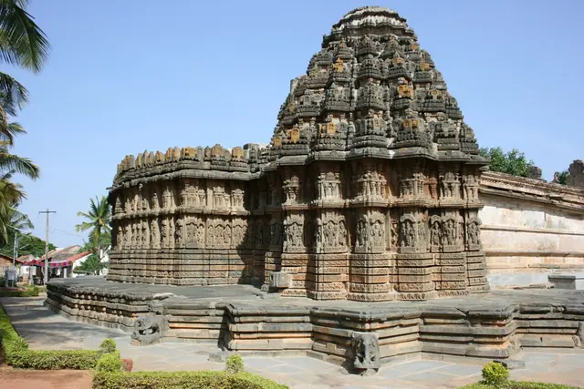
The western Hoysala temple belt — the ASI Chennakeshava of Aralaguppe, the trikuta Lakshminarasimha of Vignasante, the Kedareshwara of Nagalapura and the single-stone linga of Turuvekere’s Gangadhareshwara.

Chennakeshava Temple, Aralaguppe, Turuvekere
Practical guide

Plan Turuvekere

Who's going?Tailor Turuvekere to your trip
DistrictTumakuru
RoleHoysala-belt base
Places to visit4
What to expect

Highlights

  • Chennakeshava Temple, Aralaguppe — An ASI-protected 13th-century Hoysala temple at Aralaguppe celebrated for its intricately carved lotus-and-Ashtadikpala ceiling and fine sculpture — among the district’s finest, near the older Nolamba Kalleshvara temple in the same village.
  • Lakshminarasimha Temple, Vignasante — An ASI-protected trikuta (three-shrine) Hoysala temple at Vignasante in Turuvekere taluk, with finely carved towers and lathe-turned pillars — a lesser-visited gem of the Hoysala belt. (Distinct from the Nuggehalli and Bhadravati Lakshminarasimha temples.)
  • Kedareshwara Temple, Nagalapura — One of the twin ASI-protected Hoysala temples at Nagalapura (with the Chennakeshava temple), the Kedareshwara temple is noted for its lathe-turned pillars and finely sculpted friezes.
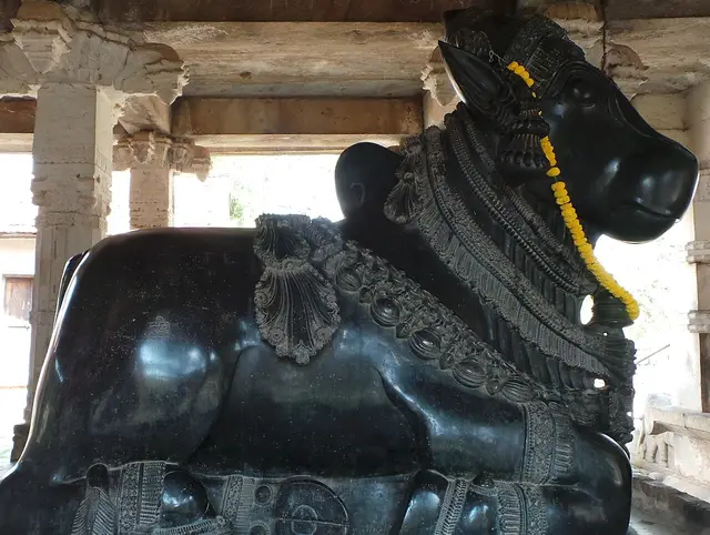
  • Gangadhareshwara Temple, Turuvekere — A Hoysala temple in Turuvekere town famed for a single-stone Shivalinga with serpent hoods, a large monolithic Nandi and a bronze soapstone bell that rings when struck. (Distinct from the Gavi Gangadhareshwara of Bengaluru.)
Getting there

How to visit

  • Nearest airport: Kempegowda International, Bengaluru (BLR) ~90 km from Tumakuru
  • Rail gateway: Tumakuru (TK) on the Bengaluru–Hubballi line, with trains from Bengaluru, Arsikere, Davanagere and Hubballi; Tiptur, Gubbi and Sira are also on the line
  • NH-48 (the Bengaluru–Pune highway) and NH-73/NH-206 run through the district; KSRTC hubs at Tumakuru, Sira, Madhugiri, Tiptur and Kunigal with frequent buses from Bengaluru. A car is best for the Hoysala belt, the hill forts and Pavagada.

Distance by road

  • Hassan94 km
  • Mysuru115 km
  • Bengaluru142 km
  • Shivamogga199 km
  • Davanagere210 km
  • Mangaluru260 km

Road distances measured on real routed roads to Turuvekere itself, not to the district headquarters, on 24 August 2026. Driving time is deliberately not published: free-flow routing badly understates a Deccan single-carriageway highway, so allow more than the distance suggests.

Timing

Best time to visit Turuvekere

Weather in TuruvekereSeasonal guide

Live forecast loads in your browser.

Today at Turuvekere
Sunrise6:12 am
Sunset6:33 pm
Golden hour best light5:33 pm–6:33 pm
Blue hour after sunset6:33 pm–6:58 pm
Sun sets toward compass bearingW · 278°
Moon tonight🌗 Last quarter · 49%

Sunset is in about 3 hours.

South-west monsoon. June to September is the south-west monsoon in Karnataka. Expect heavy showers, mostly in bursts rather than all day — carry rain cover, allow extra time for getting around, and note that ferries and open-air sites are the first things affected.

Sun and moon are calculated for this location and shown in IST. Photography windows are the hour around sunrise and sunset; the sunset bearing is degrees clockwise from true north. Moon phase is accurate to about half a day.

Practical things near Turuvekere

Mapped within about 1.2 km of Turuvekere, with real walking routes rather than straight-line distances. Community-mapped data: opening hours are shown only where they are recorded, and this is not a complete list — something unmapped may well be closer. Please confirm on the ground.

Nearby bases

Where to go from Turuvekere

Devarayanadurga, TumakuruFeatured: Devarayanadurga
Town / base

Tumakuru

The plateau capital and its hills — the twin Narasimha temples of Devarayanadurga and the Namada Chilume spring, the great Siddaganga math, the Hoysala Chennakeshava of Kaidala and the Jain hill of Mandaragiri.

DevarayanadurgaNamada ChilumeSiddaganga MathKaidala Chennakeshava Temple
Open Tumakuru guide →
Trading-town base
Town / base

Gubbi

The historic trading town on NH-206 west of Tumakuru — the Chennabasaveshwara math-temple and Gadde Malleshwara shrine.

Gubbi Chennabasaveshwara Temple
Open Gubbi guide →
Yediyur Siddhalingeshwara Temple, KunigalFeatured: Yediyur Siddhalingeshwara Temple
Town / base

Kunigal

The south-western taluk toward the Hassan and Mandya borders — the highway pilgrimage temple of Yediyur, the historic Kunigal lake and the Nava-Durga trek fort of Hutridurga.

Yediyur Siddhalingeshwara TempleKunigal LakeHutridurga
Open Kunigal guide →
Sira Fort & Jama Masjid, SiraFeatured: Sira Fort & Jama Masjid
Town / base

Sira

The old Deccan-Islamic provincial town north-west of Tumakuru — the four-sided fort and ASI Jama Masjid of Sira and the fresco-and-terracotta Narasimha temple of Seebi.

Sira Fort & Jama MasjidSeebi Narasimha Temple
Open Sira guide →
Madhugiri Fort, MadhugiriFeatured: Madhugiri Fort
Town / base

Madhugiri

The northern fort-and-grassland country — the monolithic hill fort of Madhugiri, the trekking forts of Channarayana Durga and Midigeshi, and the blackbuck grassland of Maidenahalli.

Madhugiri FortChannarayana DurgaMidigeshi FortJayamangali Blackbuck Reserve
Open Madhugiri guide →
Pilgrimage base
Town / base

Koratagere

The north-eastern taluk — the popular Mahalakshmi pilgrimage temple of Goravanahalli.

Goravanahalli Mahalakshmi Temple
Open Koratagere guide →
Border-fort base
Town / base

Pavagada

The northern near-enclave into Andhra Pradesh — the "Snake Hill" fort of Pavagada with its Kote Anjaneya and Shani shrines.

Pavagada Fort
Open Pavagada guide →
In the district

Where Turuvekere sits in Tumakuru district

Nearest airportKempegowda International, Bengaluru (BLR) ~90 km from Tumakuru
Rail gatewayTumakuru (TK) on the Bengaluru–Hubballi line, with trains from Bengaluru, Arsikere, Davanagere and Hubballi; Tiptur, Gubbi and Sira are also on the line
Bus / road accessNH-48 (the Bengaluru–Pune highway) and NH-73/NH-206 run through the district; KSRTC hubs at Tumakuru, Sira, Madhugiri, Tiptur and Kunigal with frequent buses from Bengaluru. A car is best for the Hoysala belt, the hill forts and Pavagada.
District HQTumakuru
LandscapeA large fort-and-temple district of the central Maidan plateau north-west of Bengaluru, on the granite country between the Chitradurga, Hassan and Andhra Pradesh frontiers; the Pavagada taluk juts north as a near-enclave into Andhra

Tumakuru district is known for: The monolithic Madhugiri hill fort, the Devarayanadurga hill temples, the Siddaganga math, the Hoysala temples of Turuvekere and Aralaguppe, the Sira Deccan-Islamic heritage, the blackbuck grassland of Maidenahalli and the Goravanahalli and Pavagada pilgrimages.

Madhugiri FortDevarayanadurgaSiddaganga Math
Stay · eat · do · rent · see · shop

Places in Turuvekere

Every verified place in Turuvekere — filter by what you’re after.

Verified inventory is being added here.

Verified places are being added. The category filters will fill in as approved stays, restaurants, experiences, sights, shops and nature listings go live.

List your place
For hotels, homestays and local businesses

Get listed in Turuvekere for free

Roampedia is commission-free. Travellers discover your business, book directly and contact you through official details. Basic listings are free, while Gold and Platinum package upgrades can be requested from the owner dashboard after approval.

List your business — free
Ranked guide modules

Top Turuvekere experiences

1 pick

Turuvekere-scoped cards for local planning: verified places, practical routes and source-checked visitor context.

Map

Where things are in Turuvekere

FAQ

Turuvekere travel FAQs

What are the best places to visit in Turuvekere?

Top places to visit in Turuvekere include Chennakeshava Temple, Aralaguppe, Lakshminarasimha Temple, Vignasante, Kedareshwara Temple, Nagalapura, Gangadhareshwara Temple, Turuvekere — each has a full guide with how to reach it and what to see nearby on this page.

How do I reach Turuvekere?

The nearest airport to Turuvekere is Kempegowda International, Bengaluru (BLR) ~90 km from Tumakuru. The rail gateway is Tumakuru (TK) on the Bengaluru–Hubballi line, with trains from Bengaluru, Arsikere, Davanagere and Hubballi; Tiptur, Gubbi and Sira are also on the line. NH-48 (the Bengaluru–Pune highway) and NH-73/NH-206 run through the district; KSRTC hubs at Tumakuru, Sira, Madhugiri, Tiptur and Kunigal with frequent buses from Bengaluru. A car is best for the Hoysala belt, the hill forts and Pavagada.

What is the best time to visit Turuvekere?

October to February is the coolest, most comfortable season to visit Turuvekere and the rest of Karnataka. March to May is hot on the plains, and the June–September southwest monsoon brings the main rains, heaviest along the coast and Western Ghats.

Image credits