What to expect
Highlights
- The Upper Shivalaya temple on the north hill.
- The rock-cut stairways, gateways and old granaries.
- The panorama over the caves, the lake and the town.
The Badami forts crown the sandstone bluffs on either side of the town, first fortified by the Chalukyas and later reused, reached by rock-cut stairways past bastions and granaries.

The north fort holds the Upper Shivalaya and other early temples and gives sweeping views over the caves, Agastya Lake and Badami town below.
Road km to Bagalkot; ghat roads and traffic vary — allow extra.
October to February; early morning for the climb and the light.
Live forecast loads in your browser.
Sun and moon are calculated for this location and shown in IST. Photography windows are the hour around sunrise and sunset; the sunset bearing is degrees clockwise from true north. Moon phase is accurate to about half a day.
Verified hotels, homestays, restaurants, experiences, sights, shops and rentals around Badami Fort — commission-free, with direct contact. Filter by what you need.
Verified places are being added. The category filters will fill in as approved stays, restaurants, experiences, sights, shops and nature listings go live.
List your place5 more places around Badami. Open a guide to plan the visit and onward journey.

580 m · 7 min walk
Four 6th-century rock-cut cave temples carved into the red sandstone cliff above Agastya Lake at Badami, the old Chalukyan capital of Vatapi — caves 1 to 3 are Hindu, with the great Nataraja, Trivikrama, Harihara and Narasimha reliefs and richly carved ceilings, while cave 4 is Jain.

580 m · 7 min walk
The green tank cradled between the two sandstone hills of Badami, ringed by steps and shrines and sacred to the sage Agastya; its water mirrors the cave temples on one cliff and the Bhutanatha temples on the far shore.

630 m · 8 min walk
Two clusters of 7th- to 12th-century sandstone temples standing at the water’s edge of Agastya Lake — the main Bhutanatha group on the east bank and the Mallikarjuna group to the north — among the most photographed lakeside temple scenes in the Deccan.

4.7 km · ~12 min by auto
The temple of the goddess Banashankari (Shakambhari), tutelary deity of the Chalukyas, about 5 km from Badami at Cholachagudda; the present Vijayanagara-style shrine fronts a large stepped tank (Haridra Tirtha) and draws huge crowds at the Banashankari Jatre in the Hindu month of Pushya.

4.3 km · ~11 min by auto
A walled grove of early Chalukyan Shiva temples set around the spring-fed Vishnu Pushkarni tank between Badami and Pattadakal, crowned by the Mahakuteshwara and Mallikarjuna shrines — a still-active pilgrimage cluster of the 6th and 7th centuries.
Roampedia is commission-free — own or know a stay, eatery, guide or shop near Badami Fort? List it and it appears here once verified.
Add a nearby businessEntry: Free or nominal
Climbed from the museum / Bhutanatha side (north fort) or above the caves (south fort)
If you are travelling by bus or ferry, check the return service with the operator before setting out. Leave time to reach the stop or jetty after your visit.
Ask at the bus stand for the time of the last service back, not the next one. If you miss it, an auto or app cab is the fallback — agree the fare before you get in.
If you need step-free access, contact the site before travelling. Ask about a level entrance, steps along the route, the nearest drop-off point, seating and accessible toilets.
Emergency numbers are verified against official government and state tourism sources. 112 works anywhere in India.
Four 6th-century rock-cut cave temples carved into the red sandstone cliff above Agastya Lake at Badami, the old Chalukyan capital of Vatapi — caves 1 to 3 are Hindu, with the great Nataraja, Trivikrama, Harihara and Narasimha reliefs and richly carved ceilings, while cave 4 is Jain.
580 m · 7 min walk · straight lineThe green tank cradled between the two sandstone hills of Badami, ringed by steps and shrines and sacred to the sage Agastya; its water mirrors the cave temples on one cliff and the Bhutanatha temples on the far shore.
580 m · 7 min walk · straight lineTwo clusters of 7th- to 12th-century sandstone temples standing at the water’s edge of Agastya Lake — the main Bhutanatha group on the east bank and the Mallikarjuna group to the north — among the most photographed lakeside temple scenes in the Deccan.
630 m · 8 min walk · straight lineA walled grove of early Chalukyan Shiva temples set around the spring-fed Vishnu Pushkarni tank between Badami and Pattadakal, crowned by the Mahakuteshwara and Mallikarjuna shrines — a still-active pilgrimage cluster of the 6th and 7th centuries.
4.3 km · ~11 min by auto · straight lineThe temple of the goddess Banashankari (Shakambhari), tutelary deity of the Chalukyas, about 5 km from Badami at Cholachagudda; the present Vijayanagara-style shrine fronts a large stepped tank (Haridra Tirtha) and draws huge crowds at the Banashankari Jatre in the Hindu month of Pushya.
4.7 km · ~12 min by auto · straight line
The UNESCO-listed group of 8th-century royal temples on the Malaprabha where the Chalukya kings were consecrated — a showcase of both Nagara (north Indian) and Dravida (south Indian) styles, led by the great Virupaksha and Mallikarjuna temples with the Sangameshwara and the Jain Narayana temple.
14.5 km · ~24 min by cab · straight line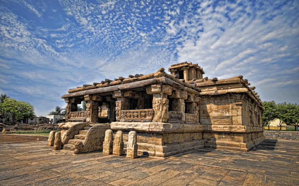
One of the earliest experimental temples at Aihole — a low, flat-roofed pillared hall of the 5th to 7th centuries that borrowed its plan from timber assembly-halls, later occupied by a Muslim named Lad Khan whose name stuck; a keystone in the study of how the Indian temple evolved.
23.8 km · ~40 min by cab · straight line
The most celebrated temple of Aihole — an apsidal, gallery-wrapped 7th- to 8th-century shrine (its name comes from the durga, or fort, beside it, not the goddess) whose carved niches of Durga, Vishnu, Shiva and Harihara are landmarks of early Chalukyan sculpture.
23.9 km · ~40 min by cab · straight line
The ASI museum beside the Durga temple complex, displaying Chalukyan sculpture, hero-stones and inscriptions gathered from Aihole’s 120-odd temples — a useful orientation to the "cradle of Indian temple architecture".
24.0 km · ~40 min by cab · straight line
The sacred confluence (kudala-sangama) of the Krishna and Malaprabha rivers in Hungund taluk — the Sangameshwara temple and the Aikya Mantapa marking the samadhi of the 12th-century reformer Basavanna make it the foremost pilgrimage centre of the Lingayat (Sharana) faith.
51.0 km · ~85 min by cab · straight line
Karnataka’s first sanctuary set aside for the chinkara (Indian gazelle), notified in 2016 across the scrub and rocky hills of the Bilagi and Mudhol taluks; it also shelters Indian wolf, striped hyena, jackal and blackbuck in a dry-country habitat unlike the state’s Ghats reserves.
56.5 km · ~94 min by cab · straight lineOctober to February; early morning for the climb and the light.
Entry: Free or nominal. Timings: Daylight hours.
The north fort is climbed from behind the Bhutanatha temples / archaeological museum side; the south fort rises above the caves. It is an unshaded rocky climb — go early, wear good shoes and carry water.
1.5 to 2 hours for the north fort.
Nearby you can pair Badami Cave Temples (580 m), Agastya Lake (580 m), Bhutanatha Temples (630 m), Mahakuta Temples (4.3 km).
Photographs: VasuVR, CC BY-SA 4.0, via Wikimedia Commons (CC BY-SA 4.0), Ganesh Subramaniam (CC BY-SA 4.0), VasuVR (CC BY-SA 4.0). Wikimedia Commons.