What to expect
Highlights
- Study the gopura and its sculptural tiers.
- Look closely at the stone mantapa and carved pillars.
- Read the Kannada inscription without touching or tracing it.
- Understand the temple-car tradition in the life of Hiriyur.
Teru Malleshwara Temple is Hiriyur’s Vijayanagara-era Shiva temple, known for its sculptured stone hall, entrance tower, inscriptions and living jatra tradition beside the Vedavathi townscape.

The sculptured gopura over the entrance to Teru Malleshwara Temple in Hiriyur.
Check entry arrangements. Ask temple staff about visitor entry, dress requirements and access to the inner shrine before you travel, especially if you are visiting as a non-Hindu.
Dress respectfully and follow the institution’s admission and photography rules.
The temple rewards a slow architectural visit. Begin at the gopura, then read the transition into the stone mantapa, where pillars and ceiling details carry the older fabric beneath later painted superstructures.
The name “Teru” points to the chariot tradition, while Malleshwara identifies Shiva. A festival visit and an ordinary worship day are different experiences, so current procession and darshan arrangements need checking.
Teru Malleshwara Temple is Hiriyur’s Vijayanagara-era Shiva temple, known for its sculptured stone hall, entrance tower, inscriptions and living jatra tradition beside the Vedavathi townscape.
The temple rewards a slow architectural visit. Begin at the gopura, then read the transition into the stone mantapa, where pillars and ceiling details carry the older fabric beneath later painted superstructures.
The name “Teru” points to the chariot tradition, while Malleshwara identifies Shiva. A festival visit and an ordinary worship day are different experiences, so current procession and darshan arrangements need checking.
Hiriyur stands on the Vedavathi, but the river is context rather than a guaranteed promenade or safe bathing place. Keep temple access, the river edge and the Vani Vilasa Sagara road outing as separate plans.
The temple is a protected and living monument. The right pace respects worship while allowing time to distinguish inscriptions, carved pillars and later repairs without touching the stonework.
Local tradition connects the shrine with Mallamma’s devotion to Shiva; present it as temple tradition rather than verified construction history.
The annual Teru Malleshwara jatra centres on worship and the temple car. Ask before photographing devotees or the procession.
The monument is associated with the Vijayanagara period and is dedicated to Shiva.
Wikidata and the Commons category preserve the spelling Malleshvara; Malleshwara is the common English variant used here.
The annual religious gathering belongs to living practice, while exact dates and present access must be confirmed locally.
See one of Hiriyur’s defining historic buildings.
Compare Vijayanagara stone architecture with later surface work.
Understand the living temple-car tradition.
Build a coherent Hiriyur heritage stop rather than passing through town.
October to February is comfortable for Hiriyur. Prefer a cooler morning or late afternoon after confirming darshan; check the current jatra date separately.
Live forecast loads in your browser.
Sun and moon are calculated for this location and shown in IST. Photography windows are the hour around sunrise and sunset; the sunset bearing is degrees clockwise from true north. Moon phase is accurate to about half a day.
Browse local stays, food, activities and useful shops. Confirm current service directly; rural options identify their own locality.
Verified places are being added. The category filters will fill in as approved stays, restaurants, experiences, sights, shops and nature listings go live.
List your placeChoose a local circuit or a separate road outing. Check worship, market and forest access independently; these places do not share one admission or timetable.

Vani Vilasa Sagara dam and reservoir near Hiriyur; enter only areas currently open to visitors.
damVani Vilasa Sagara (Mari Kanive Dam)The reservoir and dam landscape near Hiriyur is a separate excursion. Use only permitted viewing areas and follow water-project security; no swimming or boating access is promised.

The rolling hills and plateau seen from Jogimatti.
viewpointJogimattiThe forested hill landscape is a separate daylight outing from the zoo or fort. Confirm the permitted road, entry and return arrangements with forest staff before leaving town.

The planted garden and seating area at Adumalleshwara; this photograph does not show the cave shrine.
templeAdumalleshwaraThe cave shrine and separately managed mini-zoo require distinct worship and zoo-entry decisions. Check current zoo hours and retain transport for the return to Chitradurga.

Temple structures and rocky terrain inside Chitradurga Fort, with the town beyond.
fortChitradurga FortThe fort’s gates, temples and water structures deserve a separate cool part of the day. Its steep stone route is different from the zoo’s garden circuit; carry water and stay off unstable masonry.
Roampedia is commission-free — own or know a stay, eatery, guide or shop near Teru Malleshwara Temple, Hiriyur? List it and it appears here once verified.
Add a nearby businessEntry: No verified current general-admission tariff is published. Optional worship services and offerings are separate decisions.
Dress code: Dress for an active religious site, remove footwear where directed and keep worship routes clear.
Photography: Exterior photography is documented, but ask before interiors, inscriptions at close range, worship or people.
Parking: Use a locally directed parking or drop-off and keep the temple-car and procession route clear.
The temple is explored on foot. Autos are practical within Hiriyur; retain a car for the dam or other out-of-town places.
Online taxis: Do not assume an app taxi will accept the pickup. Confirm the return before arrival and retain a vehicle where Teru Malleshwara Temple, Hiriyur lies outside a busy town centre.
If you are travelling by bus or ferry, check the return service with the operator before setting out. Leave time to reach the stop or jetty after your visit.
Ask at the jetty or stand for the time of the last service back, not the next one. If you miss it, an auto or app cab is the fallback — agree the fare before you get in.
Checked 5 September 2026 against source 1source 2. Conditions change and surfaces vary with weather — if step-free access is essential, confirm with the site before you travel.
These services are listed within about 1.2 km of Teru Malleshwara Temple, Hiriyur. Walking distances follow mapped routes; access and opening hours can change. Other services may be closer but are not included here.
Emergency numbers are verified against official government and state tourism sources. 112 works anywhere in India.
Hiriyur has town restaurants and highway food stops. Eat outside the temple precinct and use the current local inventory above.
Explore food in Hiriyur →A practical breakfast before a temple visit or reservoir drive.
Choose a town lunch and confirm serving hours locally.
Local stops come first, followed by separate district outings. Check each place’s own access and return journey; this is a choice of visits, not a single walking circuit.
Vani Vilasa Sagara dam and reservoir near Hiriyur; enter only areas currently open to visitors.
damVani Vilasa Sagara (Mari Kanive Dam)The reservoir and dam landscape near Hiriyur is a separate excursion. Use only permitted viewing areas and follow water-project security; no swimming or boating access is promised.
The rolling hills and plateau seen from Jogimatti.
viewpointJogimattiThe forested hill landscape is a separate daylight outing from the zoo or fort. Confirm the permitted road, entry and return arrangements with forest staff before leaving town.
The planted garden and seating area at Adumalleshwara; this photograph does not show the cave shrine.
templeAdumalleshwaraThe cave shrine and separately managed mini-zoo require distinct worship and zoo-entry decisions. Check current zoo hours and retain transport for the return to Chitradurga.
Temple structures and rocky terrain inside Chitradurga Fort, with the town beyond.
fortChitradurga FortThe fort’s gates, temples and water structures deserve a separate cool part of the day. Its steep stone route is different from the zoo’s garden circuit; carry water and stay off unstable masonry.

The lake outside Chandravalli’s caves, photographed in 2013. The boat in this older image is not a promise of current boating access.
caveChandravalliThe archaeological valley beside Chitradurga combines settlement history, caves and a lake. Confirm any cave access locally; use established paths and keep open water separate from the visit.

The narrow Onake Obavva passage between rock and masonry inside Chitradurga Fort.
heritageOnake Obavva KindiThe remembered defensive passage is inside the Chitradurga Fort visit. Reach it through the permitted fort circuit; it is not a separate road destination or a second fort admission.
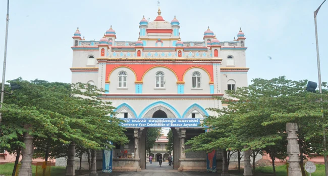
The public entrance to Muruga Rajendra Matha in Chitradurga.
heritageMurugharajendra Matha & Muruga VanaThe matha and associated grounds form a separate institutional and religious stop around Chitradurga. Confirm which visitor areas are open and follow current campus instructions.
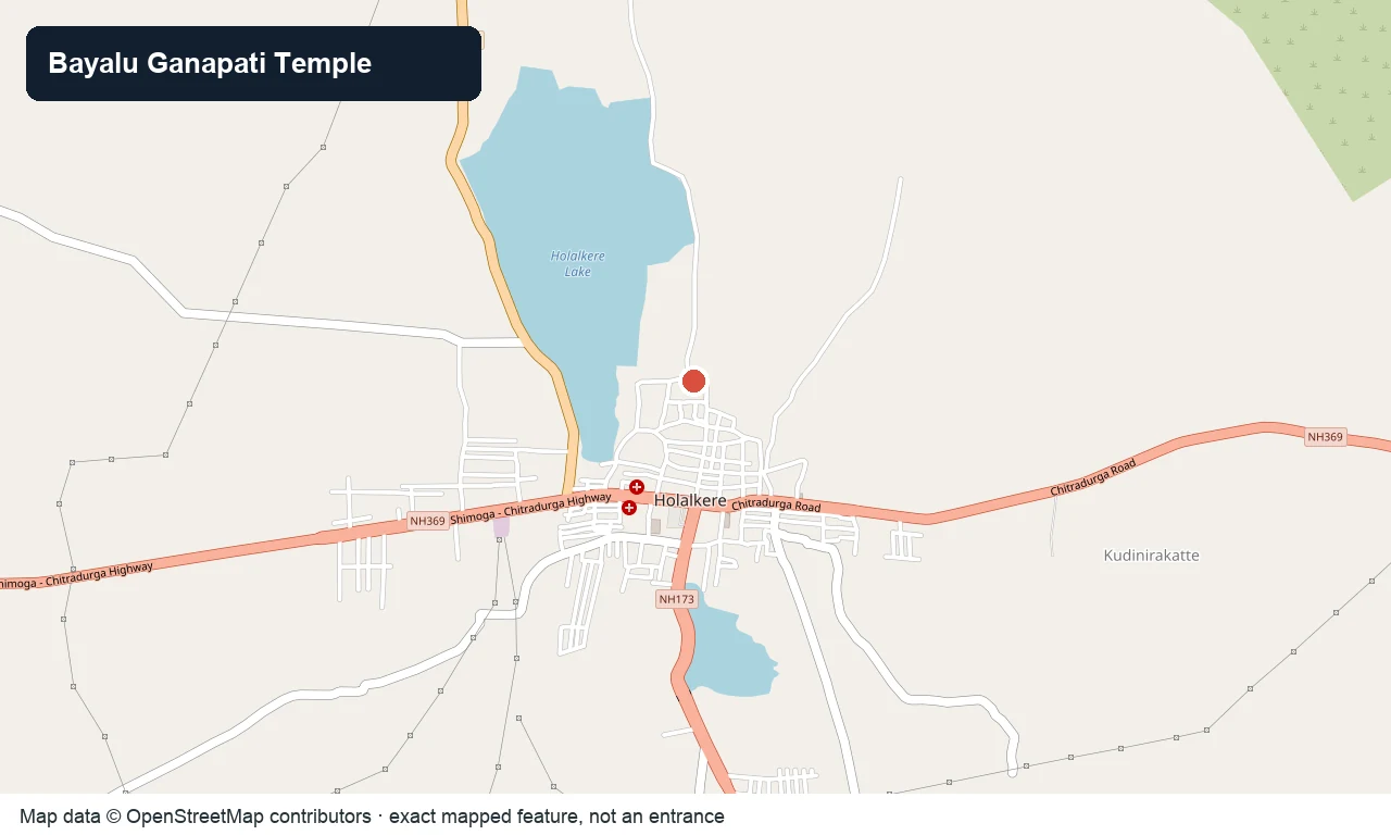
OpenStreetMap view centred on the mapped Bayalu Ganapati shrine in Holalkere; the marker is not a parking gate.
templeBayalu Ganapati Temple, HolalkereThe Ganapati worship site at Holalkere can anchor a separate town stop. Follow the entrance notice and leave the approach clear for devotees and street traffic.
Nearby toilets, pharmacies, ATMs, seating and vets are community-mapped and may be incomplete or out of date. Map data © OpenStreetMap contributors | Walking times © openrouteservice.org by HeiGIT
The locator identifies the temple precinct. Use the currently open worship entrance and follow any procession diversions.
Teru Malleshwara Temple is Hiriyur’s Vijayanagara-era Shiva temple, known for its sculptured stone hall, entrance tower, inscriptions and living jatra tradition beside the Vedavathi townscape.
Hiriyur is on the Bengaluru–Chitradurga corridor; navigate to the temple feature in town and use the permitted approach. KSRTC and other buses serve Hiriyur. Confirm the last return and take a local auto for the final approach if needed.
October to February is comfortable for Hiriyur. Prefer a cooler morning or late afternoon after confirming darshan; check the current jatra date separately.
No verified current general-admission tariff is published. Optional worship services and offerings are separate decisions.
Confirm the current darshan periods locally; do not assume continuous all-day access or rely on an old directory timetable.
The public sources do not document a continuous step-free circuit. Confirm the nearest drop-off, entrance thresholds and access to the mantapa before travel.
October to February is comfortable for Hiriyur. Prefer a cooler morning or late afternoon after confirming darshan; check the current jatra date separately.
Entry: No verified current general-admission tariff is published. Optional worship services and offerings are separate decisions. Timings: Confirm the current darshan periods locally; do not assume continuous all-day access or rely on an old directory timetable.
Allow 45 to 75 minutes for worship and architecture, longer during a festival queue.
Nearby you can pair Vani Vilasa Sagara (Mari Kanive Dam), Jogimatti, Adumalleshwara, Chitradurga Fort.
Stone thresholds and floors can be slippery when wet. Do not touch carvings or inscriptions or obstruct worship queues. Keep away from unprotected river edges and do not infer bathing access.
Local stories and practical reading for a visit to Teru Malleshwara Temple, Hiriyur and its surroundings.

A river and hill landscape near Hiriyur, shown as local context; it is not Teru Malleshwara Temple.

The hill landscape near Hiriyur, shown as town context rather than a photograph of the temple inscription.

A riverside landscape near Hiriyur, shown as town context rather than a view inside Teru Malleshwara Temple.

Shanti Sagara near Channagiri, a different regional water landscape used to frame safe reservoir planning.
Photographs: Dineshkannambadi (CC BY-SA 4.0), Singhv796, CC BY-SA 4.0, via Wikimedia Commons (CC BY-SA 4.0), Nikhil0000711 (Public domain), Ramjaiswal75, CC BY-SA 4.0, via Wikimedia Commons (CC BY-SA 4.0), Nagarjun Kandukuru from Bangalore, India, CC BY 2.0, via Wikimedia Commons (CC BY 2.0), Basavaraj M, CC BY-SA 4.0, via Wikimedia Commons (CC BY-SA 4.0), SWE-Yaatrik (CC BY-SA 4.0), OpenStreetMap contributors (ODbL 1.0), Siddarth.P.Raj, CC BY-SA 3.0, via Wikimedia Commons. Wikimedia Commons.