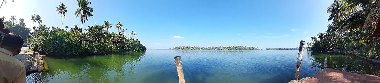
The name of this lake sets you a counting problem it cannot answer. Ashta is eight; nobody can tell you which eight arms, and the published lists contradict each other and, in one case, themselves.
The shore has a unit that does count, though, and it is not the arm. It is the kadavu.
What a kadavu is
A kadavu is a landing — the place where a path or a road reaches the water and stops, where a boat can come in, where people cross. In Kerala the word is everywhere in place names, and it is doing real work: it marks the point at which land-based movement hands over to water-based movement. On a lake with long arms and few bridges, kadavus are how the geography is actually organised.
They are also, incidentally, viewpoints — because a landing is by definition a spot where the ground gives you clean, unobstructed access to open water, usually with somewhere to stand.
About twenty of them, mapped and named
OpenStreetMap records something in the order of twenty named landings and jetties around Ashtamudi. Going roughly around the water: Ashtamudi Boat Jetty at 8.95912, 76.59748; Vallakkadavu at 8.97172, 76.60263; Pattomthuruthu at 8.97764, 76.60942; Pezumthuruthu at 8.97230, 76.60742; Pallayattu Kadavu at 9.00089, 76.61128; Vellimon Kadavu at 8.96385, 76.62871; Kaithakodi Kadavu at 8.95784, 76.65796, which is also mapped as a park; Prakkulam at 8.94549, 76.58662; Vadakkekkara Sangakkadavu at 8.95446, 76.60439; Koivila at 8.98759, 76.58107; Perungalam at 8.98486, 76.59594; Cherikkadavu at 8.99647, 76.58370; Plavara at 8.91761, 76.58323; Thoppilkadavu at 8.89557, 76.57265; Panamukkam at 8.90780, 76.57507; Kottayathu Kadavu at 8.90513, 76.57847; Manalil at 8.93697, 76.57719; Kavandu at 8.92000, 76.56298; Kandachira Kadavu at 8.93180, 76.61746, with a park called Kandachira Evening Park on the same ground; and a park at Chekkottu Kadavu at 8.90034, 76.59305.
That is a lot of public access to a lake that is routinely described as having none. Several of those names appear on the state ferry rosters as scheduled stops, which is the clearest possible evidence that they are real, reachable places rather than map artefacts.
And six viewpoints with no name at all
Separately from the landings, the map carries six outlooks tagged as viewpoints that nobody has named: 8.93577, 76.53572 on the Neendakara and Chavara side near the sea mouth; 8.95555, 76.53267 on the Chavara Thekkumbhagom shore; 8.98450, 76.61939 in the Munroe Island interior; 9.00010, 76.61930 at the north of the island; 9.01037, 76.65971 to the north-east on the Kallada side; and 8.89430, 76.55358 on the seaward side of Kollam town.
We give those as coordinates rather than as destinations, deliberately. Somebody stood at each of them and thought the view was worth recording. That is all we know, and it is enough to be useful without being a promise.
The bridges are the other public vantage
The bridges do what the kadavus cannot, which is to put you out over the middle of the water. Neendakara Old Bridge, at 8.93490, 76.54473, is the low 1972 crossing beside the newer high-level highway span, and it is the place where you can stand on public ground and look at the single point where this whole estuary meets the Arabian Sea. The Kavanad–Kureeppuzha bypass crossing at 8.92280, 76.56509 is the long, high one over the western basin. The Dalavapuram bridge at 8.94953, 76.55472 sits between two landings, with a built kadavu and public ground at Guhanandapuram at 8.95571, 76.55588 on the Chavara side, looking back east across the water. The Chavara road bridge at 8.97224, 76.53409 is the northern highway crossing. Thevally bridge, at 8.90347, 76.57939, carries the road over the arm below Thevally Palace.
Between the bridges, the landings and the Ashramam parks in town, there is more free public access to Ashtamudi than to most lakes in India that are half as famous.
What you look at from them
The water has its own named things, and knowing them turns an empty view into a legible one. Kakkathuruthu — mapped in English as the Island of Crows — lies at 8.96187, 76.60665. Vedan Chadimala is at 8.98723, 76.59515, Ottakkandal at 8.98525, 76.61777, Palliyathuruthu at 8.97540, 76.62106, and a feature mapped as Kandal Cave at 8.98680, 76.62230. Sambranikodi, the island reached only by boat, is at 8.92882, 76.56703 with its own landing just to the east.
How to use a kadavu, and how not to
Some plain warnings, because this is the part where a listing would oversell.
A kadavu is working infrastructure, not an attraction. There are no facilities, no railings, no lighting and no ticket. Several sit at the end of narrow lanes between houses, and the ground on either side is somebody’s. Being mapped is not the same as being maintained: expect a concrete step, a couple of posts and a lot of water, and expect that at some of them there will be nothing but mud.
Go in daylight, park where you are not blocking the lane, ask before walking through what is obviously a yard, and stand aside when a boat comes in — it is somebody’s route home rather than a photo opportunity. If a landing is busy with a scheduled ferry, you are welcome; that is exactly what it is for.
The count that works
You cannot count the arms of this lake. The state tourism board will not name them, the encyclopedias disagree with each other and with themselves, and one widely-copied list manages to include Ashtamudi as one of the eight arms of Ashtamudi.
You can count the landings. There are about twenty of them with names on, six more outlooks with no names at all, five bridges, and a run of public parks in the middle of a town. That is a shore you can actually plan a day around — which is more than the number eight has ever done for anybody standing on it.
Frequently asked questions
What does "kadavu" mean?
A landing or ferry point — the place where a road or path reaches the water and a boat can come in. It appears constantly in Kerala place names, and around Ashtamudi it is the unit that actually organises the shoreline.
Are the kadavus worth visiting as viewpoints?
Yes, with realistic expectations. A landing gives clean open-water access and somewhere to stand, which is most of what a viewpoint is. It does not give you railings, lighting, parking or a ticket office, and some are little more than a step and two posts.
Which ones are easiest to reach?
The ones that are scheduled ferry stops, because they have roads to them and boats using them — Sambranikodi, Koivila, Perungalam, Plavara, Vallakkadavu and Pezumthuruthu among others all appear on the state Water Transport Department rosters out of Kollam.
Where can I see the lake meet the sea?
From Neendakara Old Bridge at 8.93490, 76.54473 — the low 1972 crossing beside the newer high-level highway bridge. It is public, free, and it looks directly at the single mouth through which the whole estuary reaches the Arabian Sea.
Are there viewpoints nobody has named?
Six of them on this lake, mapped as viewpoints in OpenStreetMap with no name attached — near the sea mouth at Chavara, on the Thekkumbhagom shore, twice on Munroe Island, on the Kallada side to the north-east, and on the seaward side of Kollam town. We list them as coordinates rather than as destinations, because a coordinate is all anyone has recorded.
Is it all right to walk down to a landing?
Generally yes, in daylight and with some care — they are public access points. But they run through and past private ground, they are somebody’s route home, and they have no facilities of any kind. Ask if it looks like a yard, do not block the lane, and stand aside when a boat comes in.