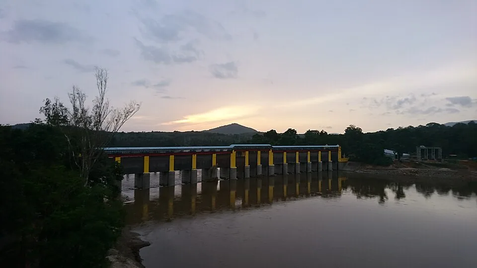
The name of Bhoothathankettu means, near enough, the demons’ dam, and it belongs to the boulders in the river rather than to anything anyone built. That legend is the reason most people come. It is also the reason almost nobody looks at the barrage they are actually standing on, which is a pity, because it is one of the more consequential pieces of infrastructure in Ernakulam district.
What is here
The barrage sits on the Periyar outside the village of Pindimana, about 10 km from Kothamangalam and roughly 50 km from Kochi, where the river’s tributaries come together at the edge of the Thattekkad forest belt. It is a barrage rather than a high dam — a long line of gates across the river rather than a wall holding back a deep reservoir — running about 210 metres and carrying fourteen shutters.
It is the headworks of the Periyar Valley Irrigation Project. Construction started in 1956; the scheme was commissioned in stages through the 1960s, with sources variously dating the opening to 1964 and partial commissioning to 1967. Water is diverted from here into a left-bank canal system.
Four jobs, not one
The obvious job is irrigation, and the number is large: the project is designed to irrigate on the order of 32,800 hectares of agricultural land in Ernakulam district. That is the flat country between here and the coast, and a great deal of what grows on it depends on gates being opened here.
The second job is drinking water. The scheme also supplies water for domestic and industrial use in Greater Kochi. If you have drunk a glass of water in the city, there is a reasonable chance it started its managed life at this barrage.
The third is less obvious and rather elegant: tidal control. The lower Periyar is close enough to sea level that salt water pushes upstream at high tide, and maintaining flow from Bhoothathankettu is part of how that intrusion is held back. The fourth is that the stored water feeds lift-irrigation schemes along the way.
- Barrage length about 210.92 m, with 14 shutters, on the Periyar at Pindimana.
- Periyar Valley Irrigation Project: construction begun 1956, commissioned in stages through the 1960s.
- Designed to irrigate on the order of 32,800 hectares in Ernakulam district.
- Also supplies drinking and industrial water to Greater Kochi and helps control tidal salt intrusion in the lower Periyar.
- About 10 km from Kothamangalam and roughly 50 km from Kochi; Idamalayar dam is about 15 km further on.
Why the legend and the engineering are the same story
The old story says demons set out to dam the Periyar in a single night, in order to flood the country upstream and submerge the Shiva temple at Thrikkariyoor; Shiva faked the dawn with a rooster’s crow, they fled, and the half-built dam is the boulder field you can see below the barrage. The documented explanation for the boulders is a major flood of the Periyar in the mid-fourteenth century.
Both versions are about the same thing: the idea that this particular point on the river is where you would stop it if you were going to. The legend imagines it done overnight by supernatural labour and abandoned in a panic. The state did it with fourteen shutters over eleven years and has been operating it ever since. The site chose itself either way.
Seeing it
Practically, this is a Kerala family picnic spot — a barrage, a reservoir, a boat jetty, riverside walks and a children’s park — and the DTPC runs authorised motorboat trips of about an hour from the jetty. Go early for the light and the birds, and remember that this is a managed river: levels change because someone opens a gate, not because the weather did something. Boat only with the authorised operators, and stay off the boulders.
Frequently asked questions
What is the Bhoothathankettu barrage for?
It is the headworks of the Periyar Valley Irrigation Project. It diverts water into a left-bank canal system to irrigate on the order of 32,800 hectares in Ernakulam district, supplies drinking and industrial water to Greater Kochi, feeds lift-irrigation schemes, and helps hold back tidal salt intrusion in the lower Periyar.
When was Bhoothathankettu built?
Construction of the Periyar Valley Irrigation Project began in 1956 and the scheme was commissioned in stages through the 1960s — sources variously give 1964 as the opening and 1967 as partial commissioning. The barrage itself runs about 210.92 metres with fourteen shutters.
Is Bhoothathankettu a dam or a barrage?
A barrage — a line of gates across the river that regulates and diverts flow — rather than a high dam impounding a deep reservoir. The distinction matters on the ground: what you are looking at is a control structure, and the water level behind it is a managed number.
Where exactly is it?
On the Periyar outside the village of Pindimana, about 10 km from Kothamangalam and roughly 50 km from Kochi, at the confluence of the river’s tributaries on the edge of the Thattekkad forest belt. The Idamalayar dam is about 15 km further along.
What is the legend of the boulders?
That demons — bhoothams — set out to dam the Periyar overnight in order to flood the land upstream and submerge the Shiva temple at Thrikkariyoor, and that Shiva faked the sunrise with a rooster’s crow so they abandoned the work and fled. The documented explanation for the boulder field is a major Periyar flood in the mid-fourteenth century.
Can you go boating at Bhoothathankettu?
Yes. The DTPC jetty near the barrage runs motorboat trips of about an hour, extendable on request. Use the authorised operators only — this is a managed river whose level changes when gates are opened, not only when it rains.