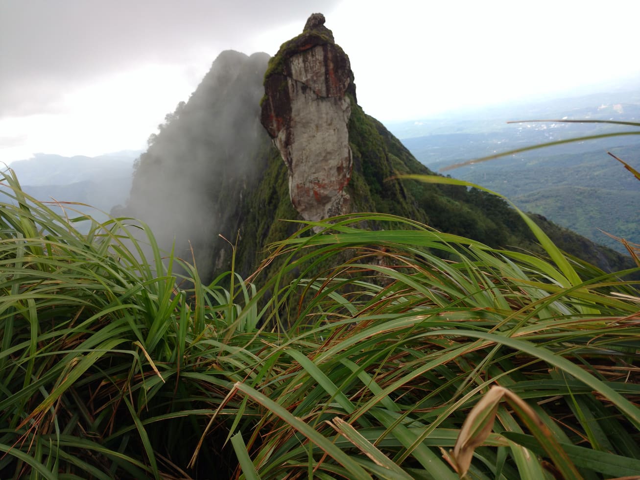
From the plains of Meenachil, Illikkal Kallu looks like something a giant sheared with a blade. The rock rises clean out of the green Kottayam highlands and narrows, near the top, to a ridge so thin it seems to have been cut rather than weathered. Stand on it and the Western Ghats fall away on both flanks — a landscape that feels less like a viewpoint than like the edge of the world.
A half-lost monolith
The drama of Illikkal Kallu is a story of what is missing. It is described as the surviving half of a much larger monolith — the other half is said to have sheared away and fallen, leaving the sheer face and the improbable, tapering ridge that give the rock its knife-edge profile. What remains rises to somewhere around 1,036 metres, roughly 3,400 feet, above sea level, though you will see higher figures quoted; the individual humps are often put at around 4,000 feet.
Look closer and the summit is not one point but several. The formation gathers a cluster of rocky knolls, each named for its shape — an umbrella-like dome here, a hunch-backed crag there — linked by natural spans. The most famous of these is a ribbon of rock barely half a foot across, known locally as Narakapalam, the bridge to hell: a single geological detail that has earned more nervous glances than any other in the range.
The view: High Ranges to a sliver of sea
The reward for the climb is one of the widest panoramas in central Kerala. Turn one way and the High Ranges of the Western Ghats stack up in blue-grey layers towards Idukki. Turn the other and the land tips downward through rubber-green foothills and paddy to the Meenachil plains. On the clearest days — and you need a clear day for this — the Arabian Sea appears far off as a single thin blue stroke laid along the horizon, an astonishing thing to see from a rock this far inland.
- The layered High Ranges of the Western Ghats towards the east.
- The Meenachil plains and foothills unrolling to the west.
- On clear days, the Arabian Sea as a thin blue line on the horizon.
- Cloud and mist moving through the valleys far below your feet.
Grassland, kurinji and the shola world
For all its bare rock, Illikkal Kallu is clothed in the distinctive plant life of the high Western Ghats. Its upper slopes are open, wind-combed grassland — the meadow half of the shola-grassland mosaic that defines these southern heights, where rolling grass gives way to dense evergreen shola tucked into the folds and hollows.
It is grassland of exactly the kind that the celebrated Neelakurinji favours — the endemic shrub of the high ranges whose mass purple-blue bloom, in its rare years, can wash whole hillsides in colour. Through the ordinary seasons the slopes shift with the light and the rain: bleached gold in the dry months, deep green after the monsoon, flecked with wildflowers and the small hardy plants that cling to the thin mountain soil.
Sunrise, sunset and the sea of cloud
The rock is at its most theatrical at the ends of the day. At dawn the valleys below often brim with cloud, so that the summit floats above a slow white sea while the first light catches the ridge. Sunset can be just as fine, and the hill is known for evenings when a full moon rises in the east as the sun goes down in the west — the two lights briefly sharing the sky over the ranges.
Weather is the whole show here. In the post-monsoon clarity the horizons run for miles; in the monsoon the same summit disappears entirely into drifting mist, and the rock becomes a study in grey silhouettes and moving cloud. Either way, Illikkal Kallu is a place where you watch the sky as much as the land — because up on that blade of rock, the two are never far apart.
Frequently asked questions
How high is Illikkal Kallu?
It stands at roughly 1,036 metres, about 3,400 feet, above sea level, with the individual rocky humps often cited at around 4,000 feet. Some sources quote higher figures, so treat the numbers as approximate.
Why does the rock have such a sharp, blade-like shape?
It is described as the surviving half of a larger monolith — the other half is said to have sheared off and fallen, leaving the sheer face and the narrow, tapering summit ridge that give it its knife-edge look.
What is Narakapalam?
It is a natural rock span between the summit humps, only about half a foot wide, whose name means the bridge to hell. It is the mountain’s most notorious feature and is best viewed rather than crossed.
Can you see the sea from Illikkal Kallu?
On clear post-monsoon days the Arabian Sea can appear far off as a thin blue line along the horizon, alongside sweeping views of the High Ranges and the Meenachil plains.