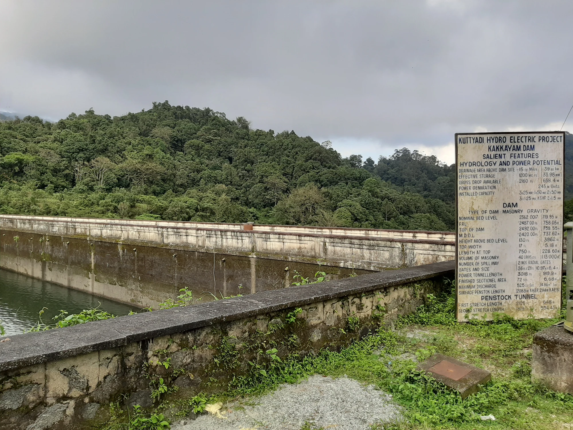
A visitor arriving at Kakkayam can encounter another name in the engineering records: Kuttiady Dam. The names describe different aspects of the same setting. Kakkayam locates the visitor landscape and settlement; Kuttiady identifies the dam and hydroelectric scheme recorded by KSEB.
Read the asset name
KSEB’s Dam Safety Organisation places Kuttiady Dam at Kakkayam in Koorachund, Kozhikode district, across the Kuttiadypuzha. It records completion in 1972. These details distinguish the asset from dams on the Chaliyar and from Banasura Sagar on the Wayanad side of the hills.
The official river identification matters because a generic destination account can attach the wrong basin to a familiar photograph. The wooded reservoir may look similar to other Western Ghats water bodies, but the dam belongs to a particular river and operating system. Its name is a way into that geography.
Storage and generation are separate positions
The reservoir stores water for hydroelectric generation. KSEB’s account describes more than one generating installation in the wider system, including later small-hydel and tailrace uses. The water therefore has a managed onward route beyond the quiet-looking surface that dominates a visitor photograph.
A generating capacity is not the same kind of measurement as a reservoir water level. KSEB’s inventory gives full-reservoir and maximum-water levels for engineering use. Those numbers should not be presented as the elevation of the visitor’s standing point or the height climbed during a forest walk.
The dam makes the scale visible
The photograph places a project information board beside the dam wall. Its heading joins the names directly: Kuttiyadi Hydro Electric Project and Kakkayam Dam. Below it, separate groups describe hydrology, the dam and the penstock tunnel. The wall and wooded hills behind the board show where that engineering account belongs. This is an archival view from September 2019; the board’s figures are not a live report of reservoir conditions.
Farther from the dam, exposed bank can appear below the tree line. Those changing margins are part of a working storage basin. Their visibility varies with water level, so the outline photographed on one visit should not become a fixed route around the shore.
The forest visit towards Urakkuzhi adds another water form to the same broader outing: a stream and steep fall rather than a wide reservoir. The two scenes can be appreciated together while retaining their separate admission arrangements. KSEB’s hydel-tourism boat service supplies its own perspective on the lake; the Forest Department manages the walking visitor area.
Understanding those roles also improves the road plan. Lower Kakkayam is the arrival and reporting base, while the upper dam-site journey continues beyond it. A visitor who asks for the exact activity and meeting point is less likely to confuse a reservoir booking with a forest programme or an operating installation.
Leave the setting with the names connected clearly: Kakkayam for the place, Kuttiady for the dam and hydroelectric system, and Urakkuzhi for the waterfall associated with the forest outing. Each adds useful detail to the landscape instead of competing as another label for the same photograph.
Engineering reference: KSEB’s Kuttiady Dam inventory. Visitor context: Kerala Tourism’s Kakkayam programme.
Plan the visit: Kakkayam trek.