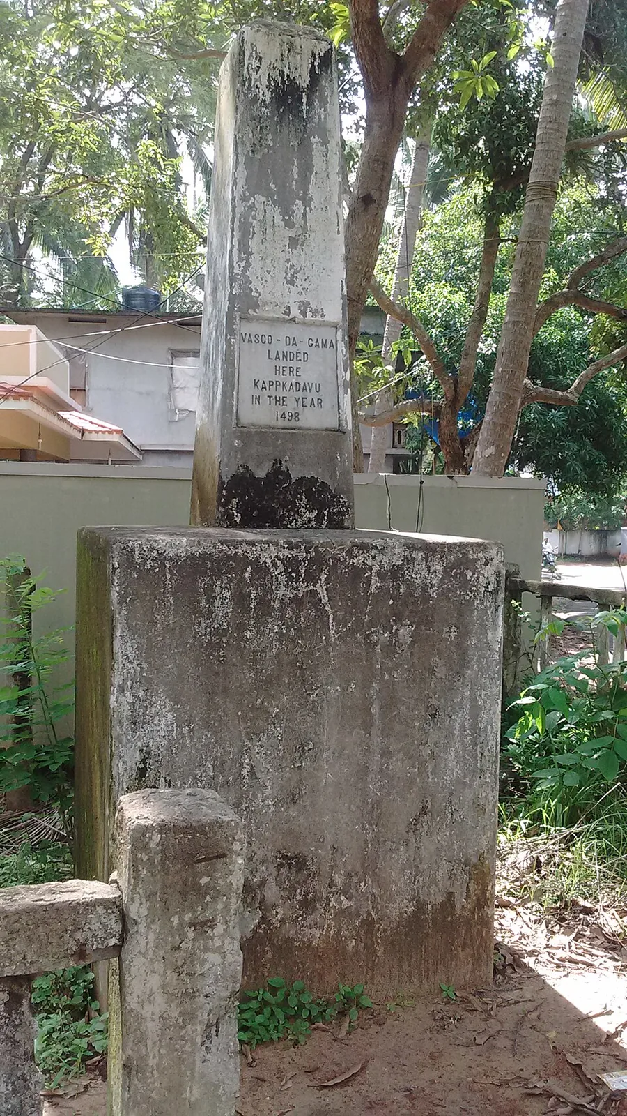
Most arguments about Kappad are about the event. This one is about the object. Set the question of where Vasco da Gama came ashore to one side for ten minutes and look instead at the thing people drive out here to photograph — because the pillar has a history of its own, and almost none of it is Portuguese.
What it physically is
A plain stone pillar, roughly five feet high, one square foot across at the top and two square feet at the base, standing on a substantial square plinth at the southern end of the beach at about 11.38002 north, 75.72226 east. It is not on the sand. In photographs it stands on hard ground behind a compound wall, with tiled roofs and coconut palms behind it and a lane running past — a roadside civic marker rather than a shoreline monument.
Set into it is a white tablet with fourteen words: Vasco da Gama landed here, Kappakadavu, in the year 1498. That is the entire text. Read it for what is not there. No day. No month. No source. No issuing authority. No date of erection. Whoever cut it committed to a year and stopped, which is a more careful piece of writing than almost anything published about it since.
A small thing you can check yourself: the Department of Archaeology and the published academic paper both transcribe the place name as Kappakadavu, but two free-licensed photographs of the tablet taken three years apart both plainly read KAPPKADAVU, with no second A. It is probably a cramped line silently tidied by its transcribers. It is also a neat emblem of how this monument gets handled.
What a real Portuguese landfall marker looked like
The contrast is worth drawing, because it is what most visitors are unconsciously imagining. Da Gama’s fleet carried padrões: dressed stone pillars, one or two of them marble, most bearing a cross and a few the royal arms, made to be set up at points that might become memorable landmarks of the voyage and as a sign of Portuguese territory. He planted them. Just not here.
No Portuguese padrão has ever been excavated at Kappad. That is not an argument from silence about a well-dug site so much as a statement of the record: the thing standing at Kappad has no physical connection to the fleet at all.
The first monument, and the sea
There was an earlier marker. The East India Company put up a pillar in the area, and the sea washed it away. That detail deserves more attention than it gets, because it is the same coast that today needs four groynes spaced about 180 to 200 metres apart along the southern half of the strand to hold its sand in place. The monument problem at Kappad has always been an erosion problem.
1939
The pillar you see was built by the Madras Government in 1939 — the attribution comes through A. Sreedhara Menon’s Kerala District Gazetteers volume on Kozhikode, at page 776, and is set out in P. T. Parthasarathi’s 2017 paper in the journal Heritage.
Four hundred and forty-one years after the event. It is worth sitting with that number. This is not a survival from the Age of Discovery; it is a piece of late-colonial civic commemoration, put up by a provincial government of British India at a moment when it had its own reasons for marking the arrival of Europeans by sea, on a beach chosen partly because it was accessible and partly because a marker had already been there.
In 1975 the Kerala Department of Archaeology notified it as a protected monument. Notification is a legal status rather than a maintenance programme: it restricts what may be done to and around the structure. It does not mean anyone is required to interpret it, and there is very little interpretation on site.
The coordinate that cannot be plotted
The best small detail in the whole file belongs to the state itself. The Department of Archaeology publishes the location of its own protected monument as 11 degrees 38 minutes 00.8 seconds north, 75 degrees 72 minutes 21.6 seconds east.
A longitude cannot have 72 minutes; sixty is the maximum. And 11 degrees 38 minutes north would place the pillar roughly 28 kilometres up the coast from where it stands. The figures are unusable as coordinates. Read the same digits as ordinary decimal degrees, though — 11.38008 and 75.72216 — and they land within about twelve metres of the memorial. Somebody typed decimals into a degrees-minutes-seconds template, and nobody has looked at it since.
So is it a fake?
No, and the question is the wrong one. Nothing about the pillar is fraudulent. It says less than its visitors assume, it is younger than they think, and it marks a spot the fleet passed rather than one anybody walked onto — but a monument that is genuinely eighty-seven years old, that replaced one the sea destroyed, and that commemorates an event which happened about eleven kilometres offshore is a considerably more interesting object than the one people come expecting.
Frequently asked questions
Who built the Vasco da Gama pillar at Kappad?
The Madras Government, in 1939, replacing an earlier East India Company pillar that the sea had washed away. The Kerala Department of Archaeology notified it as a protected monument in 1975.
Does the inscription give a date?
Only a year. The full text is “Vasco da Gama landed here, Kappakadavu, in the year 1498” — no day and no month. Claims that the plaque reads 27 May 1498 are false.
Is there a Portuguese padrão at Kappad?
No. The fleet carried dressed stone pillars, some of marble, bearing a cross or the royal arms, and da Gama planted them at other points on the voyage. None has ever been excavated at Kappad.
Where exactly is the monument?
At the southern end of the beach, at roughly 11.38002 north, 75.72226 east — on hard ground beside the lane rather than on the sand. The Department of Archaeology’s own published coordinate for it cannot be plotted as written.