Almost everywhere that rice is grown, the farming year begins with water arriving — a monsoon, a canal opening, a pump lifting water into a field. In Kuttanad it begins with water leaving.
That inversion is the whole of it, and it is not a metaphor. Roughly 490 square kilometres of this region lies one to two metres below mean sea level, and as much as 2.2 m down in the reclaimed kayal polders. The fields are basins. The water around them is higher than the soil inside them. Before you can sow, you have to empty the basin.
The padasekharam
The unit of all this is the padasekharam: a block of fields enclosed by its own bund and farmed as one hydraulic unit, though the land inside it belongs to many owners. That is an important point about Kuttanad that gets lost in the scenery — about 95 per cent of holdings here are small or marginal, so the bund is a piece of collective infrastructure that dozens of smallholders depend on and must operate together. You cannot dewater half a basin.
On the bund stands a small building called an engine thara, one to a padasekharam, and inside it are the pumps. The sequence for the year runs like this: the sluices are closed; dewatering starts about a month before sowing and lifts the water out over the bund; the basin dries; the crop goes in; it is harvested by February; and then the shutters are opened and the monsoon takes the field back. Every harvest in Kuttanad is a temporary victory over the water table, renewed annually.
From the foot-wheel to the propeller pump
The pumping technology is its own small history. The oldest form is the chakram, a paddle wheel turned by foot — human beings walking water uphill. Then came the petti and para: the petti a box and the para a paddle wheel, driven first by kerosene engines and later by electric motors. The Kerala State Planning Board's 2019 report on Kuttanad recommends replacing these with what it calls low-head, high-discharge vertical axial-flow propeller pump sets, which is a very engineering way of saying: move much more water without lifting it very far, which is exactly the problem here.
The same report makes a proposal that tells you where the real constraint lies. It recommends cutting padasekharams down from around 600 acres at present to about 250 acres — not to change what is grown or how, but so that the basins can be dewatered faster. In Kuttanad, dewatering time is the limiting factor on agriculture. That is why there are roughly 26,000 hectares of the main puncha crop and only about 11,000 of a second crop: not soil exhaustion, not sunlight, not labour. Pumping.
A calendar written by drainage
Because the constraint is hydraulic, the crop calendar reads like a drainage schedule, and the Planning Board sets out the order precisely: sowing is completed first in the kayal lands, then Lower Kuttanad and North Kuttanad, then the puncha area in Vaikom Kari, and last in Upper Kuttanad. It should be finished by the first week of November, extending to the third week in Upper Kuttanad. Dewatering begins a month ahead of each. Harvest is in February.
Before the 1960s there was only this one crop — puncha, grown in the non-monsoon months from October or November. A second crop is a modern addition and it is squeezed into whatever the water allows. If you want to know when to see green paddy below a canal, you do not need a tourism page: the crop is in the ground November to February, the polders are bare in October and flooded June to August. December to February. The two best polder photographs we could find of this landscape were taken on 24 December and 5 December, which is not a coincidence.
Three soils, three problems
What is being pumped dry is not one kind of ground. The paddy wetlands divide into three soil zones and each fails differently. Karappadam, about 33,000 hectares, is alluvial soil along the waterways, slightly higher and moderately acidic. Kayal lands, about 13,000 hectares, are the reclaimed lake-bed polders, roughly neutral, and carry a detail that ought to be better known: beneath their topsoil lie vast deposits of fossil lime shells. That is not a curiosity, it is proof of identity — this ground was the floor of a lake, and the shells are still down there.
The third is kari: about 9,000 hectares of black peaty acidic soil at or below sea level, at Vaikom, Thuravur, Ambalapuzha, Thakazhi and Purakkad. Kari soils are studied internationally as potential acid sulphate soils, and the mechanism is a cruel one for a place that farms by drainage. Drain a soil containing pyrite and the pyrite oxidises; the pH crashes; aluminium and iron become toxic to the crop. The prescription is dolomite or burnt lime. So in the kari lands the very act that makes farming possible — taking the water out — is also what sours the soil.
⚠ One correction worth carrying: “kari, karappadam, kayal, purakkad” is often listed as four soil classes. It is not. Purakkad Kari is a place-qualified kari zone, and it belongs to a different scheme — the six agro-ecological zones (Lower, Upper and North Kuttanad, Kayal lands, Vaikom Kari, Purakkad Kari) layered on top of the three soils.
Which is why Mankombu exists
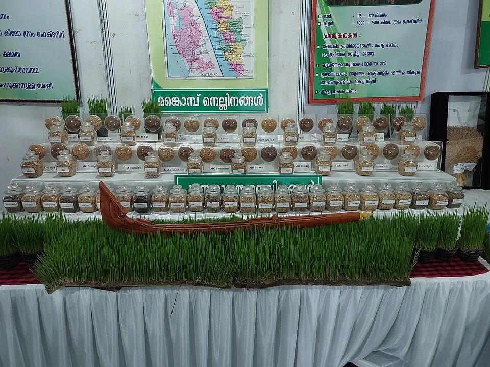
The rice grown here has to be bred for these conditions, and it is, at the Rice Research Station at Mankombu — the source of the MO-series varieties. The image at the top of this article is a display of them: jars of grain in rows, each labelled, under a board reading മങ്കൊമ്പ് നെല്ലിനങ്ങൾ, Mankombu rice varieties, with a map of Kuttanad behind and a model snake boat laid across a tray of living seedlings.
One of the panels beside it gives a variety at 115 to 120 days duration and 7,000 to 7,500 kg per hectare, and lists among its qualities that it yields well under high temperature, under acidity, and under standing water. Read that list against the three soils and the pumping calendar and you can see the whole system in it: this is a plant bred to survive a specific hydraulic regime. The variety's name sits just outside the photograph, so we are not going to guess at it.
The dominant variety in the fields is Uma. The Planning Board flags a problem with the obvious fix: a shorter-duration variety, Manuratna at 105 days, would ease the drainage squeeze, but it yields less, so farmers will not switch. A shorter crop would mean less time with the basin dry — and less rice. That trade-off, between pumping and yield, is the argument at the centre of Kuttanad farming.
Why FAO calls it a system
In 2013 the FAO designated this as a Globally Important Agricultural Heritage System, under the name “Kuttanad Below Sea Level Farming System, India”. The wording matters. What is recognised is not a soil, or a view, or a variety of rice. It is a soil plus a calendar plus a pump, plus the collective operation of a bund by dozens of smallholders who have to agree.
And it is fragile in a specific, mechanical way. In August 2018 — a flood the Planning Board assesses as a once-in-a-hundred-years event — most of the engine tharas were destroyed. Not the fields, not the bunds, not the seed: the pump houses. In a landscape farmed by removing water, losing the pumps is losing the farm. The Board recommended a package of ₹2,447.66 crore, against a precedent of ₹2,139.8 crore after the 2008 floods.
The rest of Kuttanad — the three engineering works, their costs, and the region's contested early history — is on the Kuttanad place page.
Frequently asked questions
Why is water pumped out of the fields in Kuttanad?
Because the fields lie below the level of the water around them. A padasekharam — a block of fields inside its own bund — is a basin, so it has to be dewatered before it can be sown. Pumping starts about a month before sowing, from an engine thara on the bund, and the shutters are reopened after the February harvest so the monsoon refills the basin.
What is a padasekharam?
A block of paddy fields enclosed by a single bund and operated as one hydraulic unit, although the land inside belongs to many separate owners — about 95 per cent of holdings in Kuttanad are small or marginal. The Kerala State Planning Board has recommended reducing them from around 600 acres to about 250, purely so that they can be dewatered faster.
What is an engine thara?
The small building on a padasekharam bund that houses its pumps — one per block. It is a vernacular building type most visitors walk straight past, and it is the single point of failure for the whole system: most engine tharas were destroyed in the floods of August 2018.
What are the three soil zones, and why do they matter?
Karappadam (~33,000 ha, alluvial, moderately acidic), kayal lands (~13,000 ha, reclaimed lake bed, roughly neutral, with fossil lime-shell deposits beneath the topsoil) and kari (~9,000 ha, black peaty and acidic, at or below sea level). The kari soils are potential acid sulphate soils: drain them and pyrite oxidises, the pH crashes and aluminium and iron turn toxic — so in those lands the act that permits farming is also what sours the ground.
What is the MO series of rice?
The varieties bred at the Rice Research Station at Mankombu for Kuttanad's conditions. The dominant variety in the fields is Uma; the Planning Board notes that the shorter-duration Manuratna (105 days) would ease the drainage problem but yields less, so farmers do not adopt it.