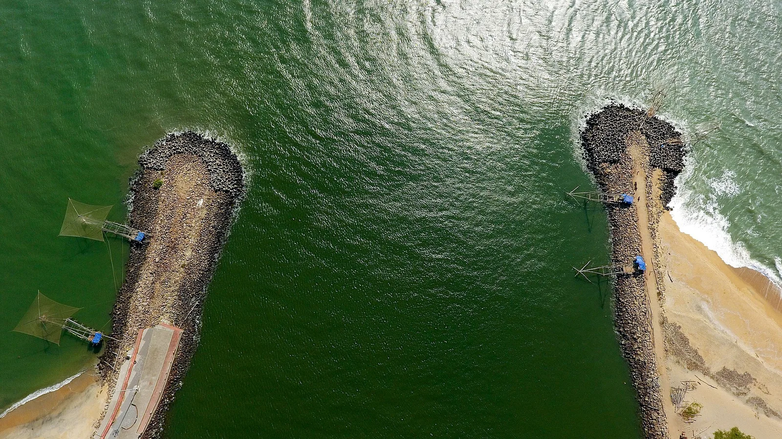
Munambam harbour is the last thing the Periyar passes before it stops being a river. Kerala’s longest river, the one that waters Idukki and Ernakulam and drives half the state’s hydroelectricity, ends in a brown swirl against a pair of breakwaters at the top of Vypin island — and according to the tradition of this coast, that river once rearranged the map in a single night.
The night the coast changed
The story, repeated the length of this shore, is that in 1341 a catastrophic flood came down the Periyar carrying an enormous load of silt. Where it met the sea, it dropped that load. Two things are said to have happened at once: the ancient port of Muziris — the richest trading station the Romans knew in the East — was choked out of existence, and a new estuary was torn open a little to the south, which became the harbour of Kochi.
The same flood is credited with throwing up the sandbar that became Vypin, the island the harbour stands on. Its calendar starts that year: the Puthuvype era, the Era of the New Deposit, still counted from 1341. So the ground under the quay, the harbour Kochi grew around, and the disappearance of the greatest port of the ancient Malabar coast are all, in the local telling, one event.
How much of that is true
Less than the telling suggests, and enough to matter. No direct account of the 1341 flood survives — the single-night version is reasoned backwards from the calendar, from the youth of the harbour and from the fact that Muziris stops appearing in the record. Coastal siltation is usually a process rather than an event.
But Muziris was real, and its loss was real. It is named in the Periplus of the Erythraean Sea, drawn on the Roman Peutinger Table, and complained about by Pliny, who reckoned the pepper trade was draining the empire of gold. Then it vanished so completely that its location was argued over for centuries. Excavations at Pattanam, inland from this coast, have produced Roman amphora sherds, beads and wharf timbers and are now the leading candidate — argued over rather than settled, which is why the heritage circuit here is named after the place rather than built on it.
- Every trawler at Munambam has to cross a bar — a shallow, shifting sand ridge at the river mouth.
- Bar crossings are governed by tide and swell, which is why landing times move.
- The breakwaters exist to hold the channel open against the sand the river keeps delivering.
- The river is still doing in slow motion exactly what the legend says it once did in one night.
The other thing the Periyar did
There is a second flood in this river’s history and that one is documented. In 1790, with Tipu Sultan’s army driving into Travancore and pressing towards the Periyar, a small Travancore party went upstream to the dam at Bhoothathankettu and breached its walls, sending a flash flood down the river the invading army had to cross. Combined with the monsoon, disease and a British declaration of war, it stopped the advance.
So the Periyar is credited with drowning a Roman port by accident and an eighteenth-century army on purpose. It is a lot of history for one brown outflow behind a fish quay, and it is all visible from the same spot.
Standing in the right place
Walk out along the harbour wall towards the breakwaters. On your left is the open Arabian Sea, on your right the last reach of the Periyar, and directly ahead the bar where the two argue with each other. Look north-east and the far bank is Kodungallur — the Cranganore of the old charters, the coast where Jewish, Christian and Muslim communities all landed by sea long before Europe arrived.
It is the most concentrated view in Ernakulam of how this whole region actually came to exist: a river, a bar, and a great deal of accumulated silt with cities built on it.
Frequently asked questions
Which river meets the sea at Munambam?
The Periyar, the longest river in Kerala. Munambam sits at its mouth on the northern tip of Vypin island, with the Arabian Sea to the west and the river to the east.
Did a flood really create Kochi harbour?
That is the tradition of this coast: a catastrophic Periyar flood in 1341 silted the ancient port of Muziris out of existence and opened the estuary that became Kochi harbour. No direct account of the flood survives, and siltation is often gradual — but the harbour is demonstrably young, and Vypin island still dates its calendar from that year.
What was Muziris and where is it?
A great ancient port of the Malabar coast, named in the Periplus of the Erythraean Sea and shown on the Roman Peutinger Table, through which much of Rome’s pepper passed. It disappeared from the record and its location was unknown for centuries. Excavations at Pattanam, inland from this coast, are the leading modern candidate, though the identification is debated.
What is the Puthuvype era?
A local calendar era on Vypin island meaning "the era of the new deposit", counted from 1341 — the year the island is held to have been formed by the Periyar flood. It is one of very few places where the land itself has a recorded starting date.
Why are there breakwaters at Munambam?
To hold the navigation channel open. A river mouth continuously deposits sand into a shifting bar, and without the breakwaters the channel that the fishing fleet uses would silt up. The bar is also why landing times shift with the tide.
Is the Bhoothathankettu flood story connected to this river?
Yes — same river, upstream. In 1790 a Travancore party breached the dam walls at Bhoothathankettu to send a flash flood down the Periyar and halt Tipu Sultan’s advance into Travancore. It is the documented counterpart to the legendary flood of 1341.