The hamlet on National Highway 544 beside the Muringoor Divine Retreat Centre is called Kottamuri. The word means the cut in the fort. Malayalam Wikipedia gives the reason without ceremony: the Nedumkotta, the wall that stood in the way of Tipu Sultan’s advance, was breached by him at the place in Muringoor known as Kottamuri, and the name has been the place’s name ever since. The site is under the protection of the State Archaeology Department.
What the wall was
The Nedumkotta — the Travancore Lines in English — was built across central Kerala in the reign of Dharma Raja Karthika Thirunal Rama Varma, of earth and stone, running from the sea in the west to the Anamalai hills in the east. Its length was measured at thirty-five miles, about 56 km, by the Cochin government’s archaeologist P. Anujan Achan, who walked the whole of it in five days in 1926 and wrote it up.
It stood forty to fifty feet high. Along its northern face ran a ditch sixteen feet wide and twenty feet deep, with thorn scrub and bamboo planted beyond it as a second obstacle. Wells were sunk at intervals for the garrison’s water. Powder magazines were built against the wall at the tactical points. Round forts stood at spaced intervals, there were over sixty encampments along it, and — the detail that gives the best sense of how it was meant to be fought — a cave in which more than a hundred soldiers could lie hidden at once. Malayalam sources credit the design and construction to the Dutch engineer Captain De Lannoy, working to a European pattern.
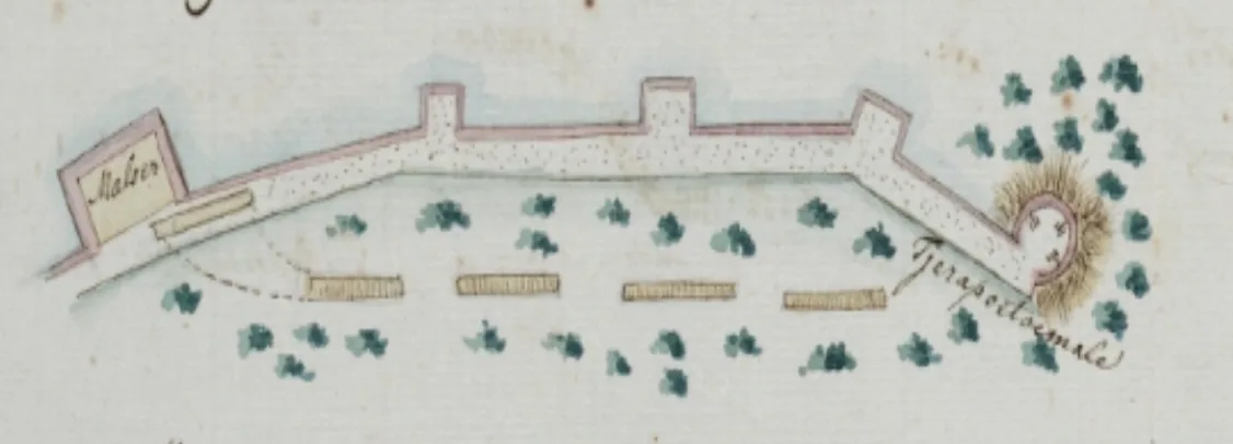
The plan at the top of this article shows one gate of it: a stretch of bastioned wall with a building block at the left labelled “Maloer” — Melur — four hatched rectangles that read as barrack or battery positions below the line, and a round work at the right ringed with a drawn thorn hedge and labelled “Tjerapoetoemale”, Cheruputhumala. It was drawn by the Dutch governor Johan Gerard van Angelbeek and is dated 14 January 1790, which places it a fortnight after the night described below and three months before the wall failed.
The night of 28 December 1789
Tipu had reached Thrissur in December 1789 and camped on the 24th at Thazhekkad, near present-day Kallettumkara, while his heavy guns were emplaced. On the night of the 28th he set out with fourteen thousand infantry and five hundred pioneers on a roundabout track towards the right of the wall at Cheruputhumala — the very work named on the Dutch plan — shown the way, the Malayalam account says, by a local man.
By nine on the morning of the 29th he was inside the line, and had gone forward on foot because the pioneers were too slow clearing a way for the army. The Travancore troops fell back as he came on. Then a party of them who had stayed hidden in a section of the wall let the Mysore musketeers get well inside and opened fire on them from behind.
That is the moment the place is named for. Malayalam Wikipedia records it in a parenthesis, almost in passing: the spot where this happened, in Muringoor village, is still called വെടിമറപ്പറമ്പ് — Vedimarapparambu, the field of the gunnery screen. Two and a quarter centuries later a field in a village of a few thousand people is still named after where a firing party lay.
The rout
What followed was a disaster in a confined space. Tipu’s commander was killed and the army broke. The way back out was too narrow for the numbers trying to use it; men were crushed, and many went into the ditch and died in it. When the palanquin bearers went down the Sultan himself fell into the ditch, and got out somehow. About two thousand Mysore soldiers died against roughly two hundred on the Travancore side, and a handful of prisoners were taken including five of Tipu’s European officers. By January 1790 he had pulled back entirely.
Two things commonly attached to that night need handling carefully rather than repeating. The first is that the fall into the ditch left Tipu with a limp: Malayalam Wikipedia reports this as something “some historians believe”, and it should be carried on exactly that footing and no firmer. The second is that it was after this night that he gave the Nedumkotta the name ഹലാക്കിന്റെ കോട്ട, the fort of ruin. That is a tradition about a nickname, not a documented utterance, and we offer it as one.
And then it failed
He came back in the spring of 1790 and the line was breached, and it is that breach that named Kottamuri. The wider war — the Dutch sale of the forts at Kodungallur and Ayacotta to Travancore in 1789, the ultimatum, the fall of Cranganur on 8 May, and the Periyar deliberately flooded upstream at Bhoothathankettu to halt the advance — belongs to Pallipuram Fort, where we tell it in full. Muringoor’s share of that history is one night, one ambush and two place-names, and it does not need the rest.
What is left
Very little, and that is worth saying plainly before anyone drives out to look. There is no visitor centre, nothing is signposted in English, and there is no ticket. What survives is a laterite bank beside a lane, three metres or so high, grassed and eroding, with a small marker on top under big trees — and, where the wall crossed the highway line, a road cutting between high banks with houses and a timber yard along the top of them. That is the monument.
It is also, on reflection, the right one. This wall was a border, drawn to keep an army out of a kingdom, and it failed. What replaced it, on the same ground, is a national highway that carries several thousand people a week to a retreat house — arriving voluntarily, from seven language communities and from outside India, through the gap where the wall used to be. Nobody planned that rhyme, and nobody at Muringoor mentions it. It is nevertheless the plainest thing about the place.
Frequently asked questions
What does Kottamuri mean?
The cut in the fort. The hamlet on NH 544 beside the retreat centre is named for the point at which Tipu Sultan’s army breached the Nedumkotta, the Travancore Lines, in 1790. The site is under the State Archaeology Department.
What was the Nedumkotta?
A rampart of earth and stone thrown across central Kerala under Dharma Raja Karthika Thirunal Rama Varma, running from the sea to the Anamalai hills. It was measured at about 56 km by the Cochin archaeologist P. Anujan Achan in 1926, stood 40 to 50 feet high, and had a ditch 16 feet wide and 20 feet deep along its northern face.
What is Vedimarapparambu?
A field in Muringoor village still named after the ambush of 29 December 1789, when a hidden Travancore party let Tipu’s musketeers pass and then fired on them from behind, breaking the assault. About two thousand Mysore soldiers died; roughly two hundred on the Travancore side.
Did Tipu Sultan really fall into the ditch?
The Malayalam account says his palanquin bearers went down and he fell in and escaped, and that some historians believe his later limp dated from it. We report that as a belief attributed to some historians rather than as established fact.
Is there anything to see?
Very little. A laterite bank beside a lane with a small marker on top, and the road cutting where the highway passes through the line. There is no visitor centre, no signage in English and no ticket.
Where is the wider Tipu story told?
On our Pallipuram Fort page, which covers the Dutch sale of the forts, the ultimatum, the fall of Cranganur on 8 May 1790 and the flooding of the Periyar at Bhoothathankettu. This article deliberately covers only what happened at Muringoor.