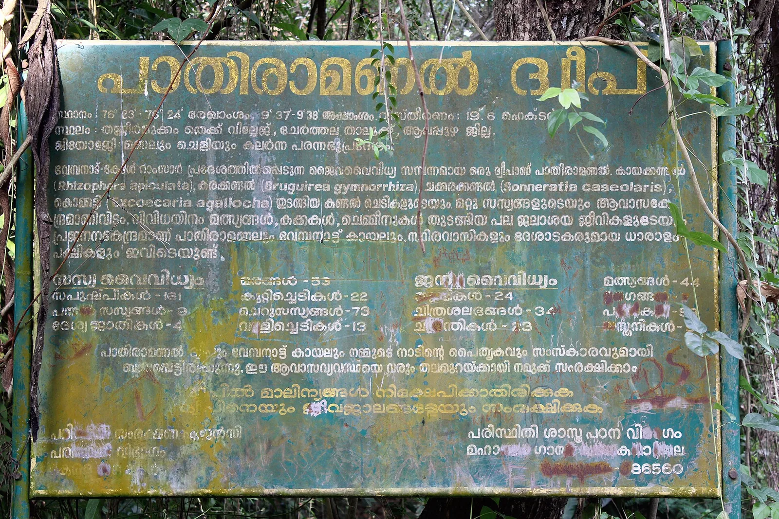
There is a green metal board on Pathiramanal, bolted between two posts under the trees. The paint is failing, somebody has scrawled across the lower third of it, and it is the single most reliable published source about the island. Almost nothing that repeats onto travel pages agrees with it.
How big is it?
Four answers are in circulation for one island you can walk across in ten minutes.
Kerala Tourism says about 10 acres, roughly 4 hectares. The board on the island says 19.6 hectares. The English Wikipedia article manages to say 19.6 hectares and 28.5 hectares in adjacent lines, apparently without noticing. And the mapped shoreline — the island’s traced outline in OpenStreetMap, measured as a polygon — encloses about 28 hectares, or roughly 70 acres.
The mapping and the larger Wikipedia figure agree with each other closely enough to be the same measurement. The board’s 19.6 hectares may well be measuring something narrower, such as the wooded core rather than the whole shoreline. What is clear is that the 10-acre figure, which is the one most widely repeated because it is the one the tourism department publishes, is not supported by anything we can check. It is seven times smaller than the mapped island. We do not print it.
The dimensions themselves are not in dispute and are more useful anyway: about 550 metres from end to end, about 450 metres across, roughly 1,800 metres around, and about 810 metres from the nearest mainland.
The bird number that belongs to somewhere else
Search for Pathiramanal and you will be told, again and again, that it shelters 91 species of resident birds and 50 species of migratory birds. The figure appears on Wikipedia without a citation and spreads outward from there.
Trace the phrasing and it comes from the Ramsar information sheet for the Vembanad-Kol wetland, where it describes the Kol area — the seasonally flooded rice lands of Thrissur district, about 100 kilometres north of this island and part of a designated site covering 151,250 hectares. The sentence was written about a landscape thousands of times the size of Pathiramanal, and it has been quietly re-pointed at a 28-hectare island.
The island is inside that Ramsar site, which is exactly how the confusion becomes possible and why it is so hard to dislodge. Being part of a listed wetland is not the same as being described by every sentence written about it.
What the board actually counts
The board was put up by the School of Environmental Sciences at Mahatma Gandhi University, and it gives numbers of a completely different character — the numbers of a survey rather than of a brochure. Flowering plants: 161, of which 53 trees, 22 shrubs, 73 herbs and 13 climbers, plus 3 ferns and 4 endemic species. Fauna: 24 birds, 34 butterflies, 44 fish.
It names four mangroves specifically — Rhizophora apiculata, Bruguiera gymnorrhiza, Sonneratia caseolaris and Excoecaria agallocha — each with its Malayalam name, and it states that the island falls within the Vembanad-Kol Ramsar area.
Now notice something. Kerala Tourism says the island has around 160 plants and about 30 butterflies. The board says 161 and 34. Tourism is plainly quoting this survey. But Tourism also says “about 90 species of birds”, where the board says 24 — and 24 is the number Tourism did not carry across.
The likeliest reconciliation is not that anyone is lying. It is that the two counts are counting different things: 24 species recorded on the island itself, and something closer to 90 recorded using the island and the open water around it, which is where the cormorants, darters, herons, egrets and winter migrants actually are. Either way, 91-plus-50 is not this island’s number and never was.
And it is not a sanctuary
One more label that will not come off. Commons captions, a Wikipedia category and a great many travel pages call this the Pathiramanal Bird Sanctuary. It is not one. Kerala’s notified bird sanctuaries are Thattekad, Kumarakom, Kadalundi, Mangalavanam and Pakshipathalam. Pathiramanal is Tourism Department land, managed under a state biodiversity-conservation and responsible-eco-tourism project, with the science supplied by the university whose board you are standing in front of. There is no Forest Department sanctuary notification.
None of this makes the island less worth the crossing. What is here is a 28-hectare remnant of mangrove-fringed swamp forest inside one of the most important wetlands in India, with a cormorant roost and a duckweed creek and a great deal of quiet. That is enough. It does not need another wetland’s statistics.
Frequently asked questions
How large is Pathiramanal Island?
Sources disagree. The island’s own government board says 19.6 hectares; the mapped shoreline encloses about 28 hectares (roughly 70 acres); English Wikipedia gives both 19.6 and 28.5 in adjacent lines. Kerala Tourism’s widely repeated “10 acres” is not supported by the mapping and we do not use it. Dimensions are about 550 m long, 450 m wide and 1,800 m around.
Does Pathiramanal really have 91 resident and 50 migratory bird species?
No. That phrasing comes from the Ramsar description of the Kol wetlands in Thrissur district, about 100 km away, within a designated site of 151,250 hectares. Kerala Tourism gives “about 90 species of birds” for the island and its surrounding water; the university board on the island records 24.
Is Pathiramanal a bird sanctuary?
No, despite the label appearing on Wikipedia, on Commons file descriptions and on many travel sites. It is Kerala Tourism Department land under a biodiversity conservation and eco-tourism project, with no Forest Department sanctuary notification. Kerala’s notified bird sanctuaries are Thattekad, Kumarakom, Kadalundi, Mangalavanam and Pakshipathalam.
Which mangroves grow on the island?
The government board names four: Rhizophora apiculata, Bruguiera gymnorrhiza, Sonneratia caseolaris and Excoecaria agallocha, each given with its Malayalam name.