Thirumullavaram has a single selling point and everybody repeats it: the water here is unusually gentle, on a coast otherwise known for drag and undertow. It is why families come, why the elderly can stand in the surf, and why two hundred thousand people can safely enter the sea here on one morning a year.
It is also, on the evidence of every photograph ever taken of the place, not natural.
The photographic record
There are two substantial sets of images of this beach, made by different people three years apart, and they agree completely.
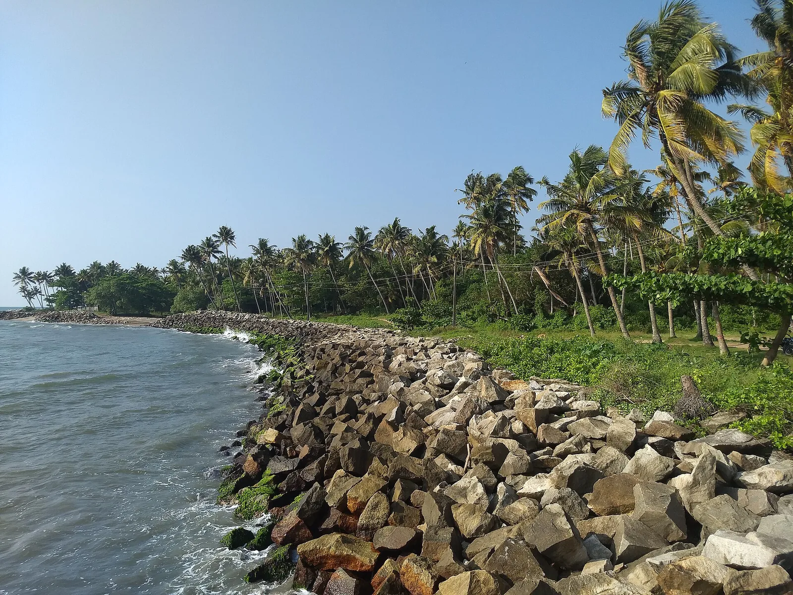
Arunvrparavur shot a panorama here in September 2015: a concrete groyne running out into the sea with people standing on it, riprap flanking it on both sides, a promenade path, and a ruined arched structure on the landward side. Ambadyanands walked the shore on 10 November 2018 and made a set of frames in a single four-minute pass between 15:30 and 15:34: a continuous revetment of angular quarried boulders, surf breaking straight onto the rock, the groyne running seaward to a lamp post, and a pocket of sand surviving in the middle distance.
The clincher is not either photographer. It is Kerala Tourism. Its own green "Welcome To Thirumullavaram Beach" signboard, photographed in 2015, carries a picture of the beach on it — and that official picture shows the rock revetment and the groyne, not sand.
What those structures are for
A groyne is a barrier built perpendicular to the shore, out into the water. Its purpose is to interrupt longshore drift — the steady sideways migration of sand along a coast — and trap sediment on the updrift side of it.
A revetment is armour laid along the shoreline itself. Its purpose is to absorb the energy of waves that would otherwise cut the shore back.
Both, working together, produce a shoreline that holds its sediment and water that behaves more gently at the edge than it otherwise would. Which is to say: the exact quality this beach is famous for is the exact quality this kind of engineering is built to create.
How far we will take that
Not as far as it wants to go, because we cannot source it. We have not found a record from the Kerala State Coastal Area Development Corporation, the Irrigation Department or any other agency naming this scheme, giving its date, or costing it.
So this is not us telling you that Thirumullavaram's calm was manufactured. It is us telling you that the photographs raise the question with some force, that the physics is straightforward, and that as far as we can tell nobody has asked it. That seems worth saying out loud rather than repeating "naturally calm" for a ninth time.
The beach four kilometres away
The contrast makes the case better than the physics does, and it needs to be labelled carefully, because it is about a different place.
Kollam Beach — the city shore, which has its own page on this site — is not armoured in the same way. Onmanorama reported in October 2025 that its shoreline is caving in and its sand vanishing; that the water reaches over three metres deep barely two metres from the shore, where the sea has scoured out pits that swimmers drop into; that drownings there are frequent; and that a warning rope a kilometre and a half long has been strung along it, which people step over.
Two beaches, four kilometres apart, on one district's coast. One is hard-armoured and is the safest water in Kollam. The other is not, and is killing people.
That is the real lesson of this shoreline, and it is a more interesting one than "hidden gem". What counts as a beach on this coast is not a fact of nature. It is a decision — one that somebody made, paid for, and has to keep paying for.
Frequently asked questions
Is Thirumullavaram beach natural?
The shoreline is substantially engineered. Photographs from 2015 and 2018 by two different photographers, plus Kerala Tourism's own illustrated signboard, all show a continuous granite revetment along the waterline and a concrete groyne running out into the sea. There is a pocket of sand, but the dominant surface is rock.
Is the calm water artificial then?
Very possibly, but we are careful here: groynes and revetments are built precisely to trap sediment and absorb wave energy, which produces exactly the gentleness this beach is known for. We could not find any agency record naming the scheme or its date, so we present it as a strongly suggested question rather than an established fact.
Does the sea really recede half a kilometre at low tide?
We doubt it. Kerala is microtidal, with a spring tidal range of roughly a metre, and a five-hundred-metre horizontal retreat would need a foreshore far flatter than any photograph of this beach shows. What people generally walk out on is the groyne, which is there at any state of the tide.
Is it safe to swim?
It is the calmest water in Kollam and widely used, but there are no permanent lifeguards, the shore is loose granite that is slippery where it is weeded, and currents shift with the tide. Stay in the shallows and supervise children.
How does it compare with Kollam Beach?
Very differently, and the contrast is instructive. Kollam Beach, four kilometres away in town, was reported by Onmanorama in October 2025 as caving in, with water over three metres deep two metres from shore, frequent drownings, and a 1.5 km warning rope. That is a separate place with its own page — mentioned here only as a contrast.