Almost everyone who stays at Kovalam is three kilometres from one of the most contested harbours in the history of south India, and almost nobody walks down to it. Vizhinjam reads today as a dense, working fishing town. For several centuries it was a prize.
The Ays
The Ay dynasty is one of the oldest ruling lines of the far south, and one of the least known outside specialist history. Their territory covered much of what is now southern Kerala and the adjoining Tamil country, and Vizhinjam — appearing in inscriptions and in Tamil sources as Vilinam — was their port and at times their seat.
That is an unusual arrangement and it tells you what the kingdom was for. Most south Indian capitals sat inland, on agricultural surplus, with a port attached. The Ays organised themselves around the anchorage itself. Vizhinjam has no hinterland resource worth the name; the town's entire historical importance rests on the water in front of it.
Why a bay is worth a war
The same feature that brought a container terminal here brought armies. Vizhinjam has deep water very close inshore — about 24 metres — on a coast that is otherwise shallow, silting and hard to approach. Ships could come close, load and leave, in weather that would have kept them off most of this shoreline.
Control the anchorage and you control the trade that passes it. So the Cholas and the Pandyas fought over Vizhinjam repeatedly through the long rivalry with the Chera–Ay powers, and the port changed hands more than once. It later fell within the orbit of the Venad rulers, who in time became the Travancore royal house.
It is worth pausing on the scale of that. This is not a regional squabble; these are the major powers of peninsular India, expending campaigns on a bay you can now walk across in twenty minutes.
The shrine in the boulder
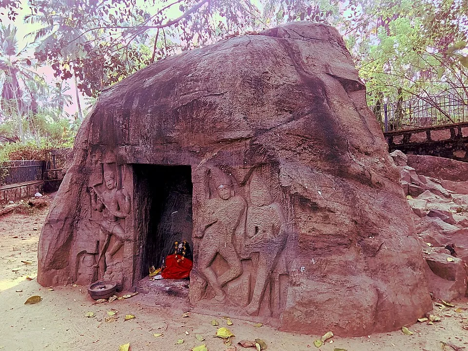
The clearest surviving trace of the Ay period is on the rise above the harbour: a small shrine cut into a single freestanding boulder, with relief figures carved on the face either side of a dark doorway. It is easy to walk past. It is also one of the oldest surviving pieces of built religion on this part of the Kerala coast.
The carvings are read locally as Shiva with Parvati and as a dancing form of the god, and the sculptures are usually placed in about the eighth century.
That century deserves a caveat that is rarely given. The shrine carries no dated inscription. The eighth-century attribution is an art-historical judgement made from the style of the carving and comparison with other rock-cut work of the period. It is a considered scholarly estimate, and different accounts read both the date and the iconography differently. Take it as the best available reading rather than a record — and it is a good reminder of how thin the documentary ground is for early Kerala generally.
Then the harbour stopped mattering
Through the colonial centuries the strategic weight drained away. European trade concentrated at Kochi, further north, with its lagoon and its European fortifications; the Travancore capital moved to Thiruvananthapuram; and the deep water at Vizhinjam became irrelevant because nothing sailing there needed it. The town settled into being what it looks like now — a dense fishing settlement with one of the busier landing centres on the Thiruvananthapuram coast, and no particular importance beyond it.
That dormancy lasted roughly five hundred years, and it ended for exactly the reason the whole story began. Container ships grew until only a handful of Indian locations could physically take the largest of them, and the bay the Ay kings built a kingdom around became, again, the most valuable water on the coast.
You can see the whole sequence from one spot. Hand-hauled catamarans on the sand, the eighth-century shrine on the rise behind, and the breakwater of the new terminal running out to sea to the south. It is worth the ten-minute autorickshaw ride from the sunloungers.
Frequently asked questions
Who were the Ay dynasty?
One of the oldest ruling lines of the far south, whose territory covered much of what is now southern Kerala and the adjoining Tamil country. Vizhinjam — known in inscriptions and Tamil sources as Vilinam — was their port and at times their capital, which is unusual: most south Indian capitals sat inland and had a port attached rather than being organised around one.
Why was Vizhinjam fought over so much?
Because of the anchorage. It has deep water very close inshore on a coast that is otherwise shallow and silting, so ships could load and leave in conditions that made most of this shoreline unusable. Controlling it meant controlling the trade passing along the coast, which is why the Cholas and Pandyas contested it repeatedly with the Chera–Ay powers.
How old is the rock-cut cave temple?
It is usually dated to around the eighth century, but that is an art-historical estimate based on the style of the carving rather than a documented date — the shrine carries no dated inscription, and accounts differ on both the dating and the reading of the figures. It is best treated as a considered scholarly judgement.
What is carved on the shrine?
Relief figures on the rock face either side of the doorway, read locally as Shiva with Parvati and as a dancing form of the god. The whole shrine is cut into a single freestanding boulder rather than built, which is what makes it notable.
Is the cave temple worth visiting?
Yes, and it takes about ten minutes. It is modest and unpolished — you could walk past it — but it is one of the oldest surviving pieces of built religion on this part of the coast, and it sits on the rise directly above the working harbour, so you see the ancient port, the artisanal fishery and the new container terminal from one place.
How do I get there from Kovalam?
About 3 km south on the coast road — a few minutes by autorickshaw, which run constantly, or a walk of roughly forty minutes. Go early, between about six and eight, so you catch the fish auction on the quay as well.