Kulithalai is a small Cauvery town where the useful visitor map has only two strong stops. Kadambavaneswarar is in the municipality beside the river; Rathinagireeswarar stands ten kilometres south on Ayyarmalai and demands a 1,017-step ascent. The scale is the attraction: arrive by rail, walk through an ordinary market town, read a living Tevaram shrine carefully, then give the hill its own cool morning.
The page begins at Kulithalai railway station, code KLT. The station sits inside the compact municipality and makes the riverside Kadambavaneswarar Temple a genuine town walk rather than a vague “nearby” claim.
Kulithalai Municipality describes an 11.16-square-kilometre second-grade municipality with a 2011 population of 27,910 and twenty-four wards. The Cauvery is not scenery pasted onto that civic record: the municipality identifies the river as its own water source. Streets between station, bus stand, market and temple therefore belong to one small working town rather than to a resort precinct.
Kadambavaneswarar temple stands north of the railway near the Cauvery. The district HR&CE inventory names it at Kadambarkoil in Kulithalai taluk and includes it in the annadhanam scheme. Its Tevaram identity and the memory of a kadamba forest are devotional traditions; neither should be turned into an unsupported construction date. Look instead at the stone halls, later painted towers and the way daily worship continues inside accumulated fabric.
Kadambavaneswarar Temple is about 1.3 km by road and 1.4 km on the walking route from Kulithalai station. Heat, traffic, missing pavements and a railway crossing can make the walk longer. The riverbank is close, but it is a working water edge: do not treat flow, sand or concrete aprons as a bathing or picnic guarantee.
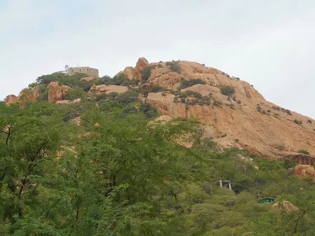
Ayyarmalai is a different settlement and a different kind of visit. Its temple node is 10.22 km by routed road from the station, near the mapped Ayyarmalai village. Tamil Nadu HR&CE states that the summit shrine is reached by 1,017 steps and describes ropeway work as ongoing. Construction is not an operating service: plan for the climb unless the temple itself confirms otherwise on the day.
The sacred account names Shiva as Rathinagireeswarar and the goddess as Surumbar Kuzhali, and includes subsidiary worship associated with Vairaperumal and Karuppannaswamy. Tradition understands the lingam as self-manifested. Those are the temple’s own religious claims, distinct from what inscriptions or architectural study can date.
This page deliberately removes Vyagrapureeswarar at Puliyur from the Kulithalai town circuit. Karur district lists Puliyur as a separate town panchayat; sharing Kulithalai taluk is not the same as belonging to Kulithalai town. A short page with two correctly assigned places is more useful than a fuller grid built from an administrative-name mistake.
A practical day starts with Kadambavaneswarar during the morning opening session, continues through the market and Cauvery context, and leaves Ayyarmalai for late afternoon only if heat, daylight and fitness permit. The safer plan is one night and an early climb next morning. Carry water, descend before the rock and steps become dangerously hot, and do not rely on a shop being open above.
Legend & myth
The name Kadambavaneswarar recalls a sacred kadamba grove. Treat that as the shrine’s living place-tradition rather than as botanical proof of what surrounded every period of the building.
At Ayyarmalai, temple tradition regards the lingam as self-manifested. The 1,017 steps give that story a bodily form: worship is approached through ascent, heat and effort, not merely viewed from a vehicle.
Names matter here. Kadambandurai connects the shrine to a river landing or bank, while Rathinagiri understands the hill as a jewel-like sacred mountain. They are devotional readings of landscape, not substitutes for mapped settlement boundaries.
More about Kulithalai
History
Kulithalai’s durable geography is the Cauvery crossing country between Karur and Tiruchirappalli. River water, wet cultivation, road movement and the railway explain why a municipality formed here; the temple preserves an older sacred name associated with Kadambandurai or Kadambarkoil.
The Tevaram association places Kadambavaneswarar within Tamil Shaiva devotional geography. That is evidence of a long-lived sacred place, not permission to assign every visible wall to one early century: temples are repaired, expanded, repainted and used over generations.
The modern civic chronology is clearer. Kulithalai was upgraded to a second-grade municipality on 22 May 1998. The municipality reports 11.16 square kilometres, twenty-four wards and 27,910 residents in the 2011 census.
Ayyarmalai remains outside the compact municipal walk and inside the wider Kulithalai planning orbit. Its hill temple and climb make the physical relationship legible: river town below, granite outcrop and pilgrimage above, linked by a short road but not by effortless access.
Why visit
For a compact Cauvery town that still works as a real railway-and-bus base rather than a packaged temple circuit.
For Kadambavaneswarar, a walkable living Tevaram shrine with layered stone and painted architecture.
For Ayyarmalai’s uncompromising 1,017-step pilgrimage and the view from a granite hill above the river plain.
To see why town, taluk and district labels must be separated when planning rural Tamil Nadu routes.
For a slow one-night itinerary that respects midday temple closures, heat and the effort of ascent.