Vajrapoha Falls

Vajrapoha is a remote waterfall on the Mahadayi system in the Jamboti forest landscape of Khanapur taluk. It lies in an ecologically sensitive sanctuary setting where official closure orders take precedence over old trek accounts and tourism timings.

Vajrapoha Falls, Khanapur

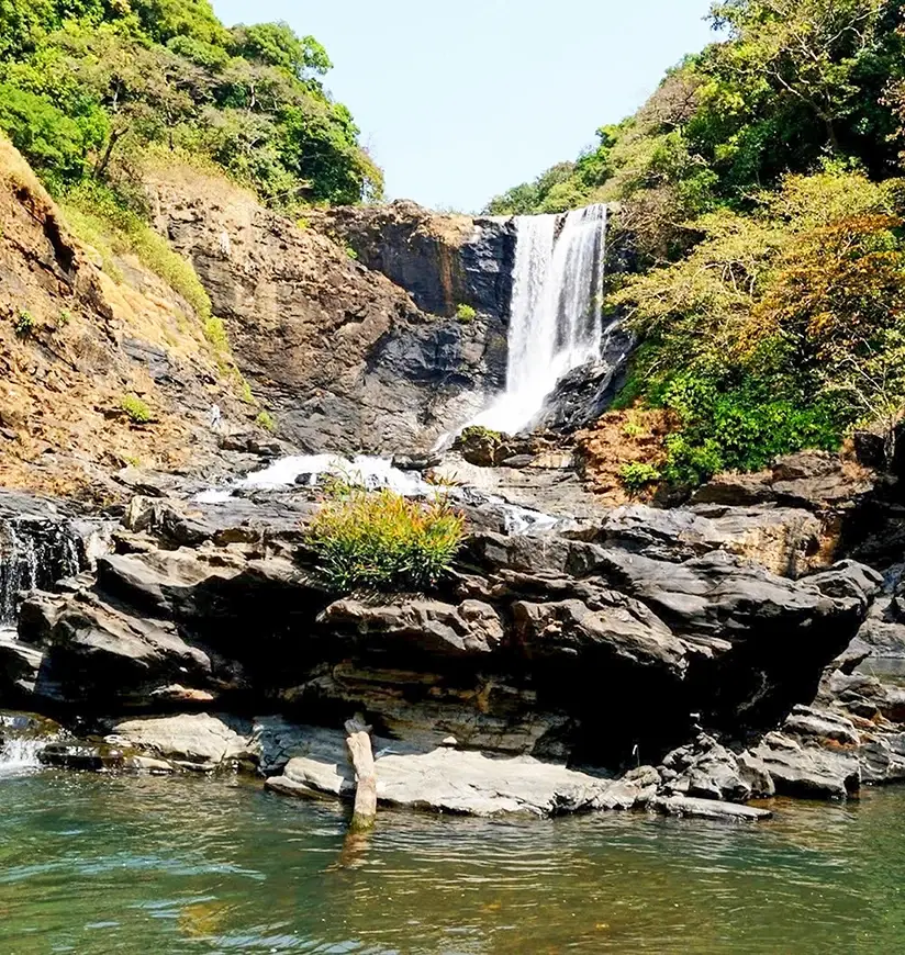
Vajrapoha Falls dropping through the forested Mahadayi headwater landscape.

Practical guide

Plan Vajrapoha Falls

Who's going?Tailor Vajrapoha Falls to your trip
Typewaterfall
Nearest baseKhanapur
DistrictBelagavi
Best timePost-monsoon when officially accessible
Time neededAllow most of a day
Places to visit4

The Mahadayi rises in the wet Western Ghats of Khanapur and runs west toward Goa, where it is called the Mandovi. Government and scientific records place Vajrapoha in this headwater country, where steep relief and exceptionally heavy orographic rain create rapids, tributary junctions and the fall into a deep wooded valley.

A Karnataka government report describes the approach beyond Jamboti and Chapoli as involving river crossings during a limited dry-season window. That historical description explains why Vajrapoha was never a simple roadside waterfall. Water depth, bridge condition, forest rules and the chosen trail can all invalidate an itinerary copied from an older account.

The most important current fact is access control. Reporting in 2025 and 2026 records a government ban on outsiders entering the Vajrapoha area within the Bhimgad Wildlife Sanctuary eco-sensitive landscape, including continued monsoon restrictions. A published 8 a.m.–4 p.m. tourism listing must therefore not be read as permission to enter.

The story

Vajrapoha is a remote waterfall on the Mahadayi system in the Jamboti forest landscape of Khanapur taluk. It lies in an ecologically sensitive sanctuary setting where official closure orders take precedence over old trek accounts and tourism timings.

The story of Vajrapoha Falls

The Mahadayi rises in the wet Western Ghats of Khanapur and runs west toward Goa, where it is called the Mandovi. Government and scientific records place Vajrapoha in this headwater country, where steep relief and exceptionally heavy orographic rain create rapids, tributary junctions and the fall into a deep wooded valley.

A Karnataka government report describes the approach beyond Jamboti and Chapoli as involving river crossings during a limited dry-season window. That historical description explains why Vajrapoha was never a simple roadside waterfall. Water depth, bridge condition, forest rules and the chosen trail can all invalidate an itinerary copied from an older account.

The most important current fact is access control. Reporting in 2025 and 2026 records a government ban on outsiders entering the Vajrapoha area within the Bhimgad Wildlife Sanctuary eco-sensitive landscape, including continued monsoon restrictions. A published 8 a.m.–4 p.m. tourism listing must therefore not be read as permission to enter.

Until the responsible Forest Department explicitly reopens a lawful visitor route, plan no trek to the falls. Khanapur and Jamboti can still serve as gateways for permitted forest experiences, but a distant landscape stop is not a substitute for authorised access. Never follow informal guides past a closure or cross the Mahadayi to reach a viewpoint.

Tradition and living practice

Local route knowledge was historically essential, but it cannot override a Forest Department prohibition.

Treat the forest as habitat: no loud music, litter, feeding, bathing, rock climbing or entry beyond barriers.

History

Official and scientific sources place Vajrapoha within the Mahadayi headwater landscape of Khanapur taluk.

A government description records the Mahadayi being joined by Maradha Nala and Pansheer Nala near the fall and notes a steep drop into the valley.

The wider Bhimgad landscape protects Western Ghats forest and wildlife habitat; current conservation controls can close routes once described in older travel material.

Why visit

Understand the Mahadayi’s high-rainfall headwater landscape from lawful public ground.

Learn why the waterfall’s flow and approach change sharply with season.

Recognise the relationship between Vajrapoha and the protected Bhimgad forest.

Make a conservation-first decision when the attraction is closed.
What to expect

Highlights

  • Understand the Mahadayi’s high-rainfall headwater landscape from lawful public ground.
  • Learn why the waterfall’s flow and approach change sharply with season.
  • Recognise the relationship between Vajrapoha and the protected Bhimgad forest.
  • Make a conservation-first decision when the attraction is closed.
Getting there

How to visit

  • Check the Karnataka Forest Department and Khanapur range status before making any journey.
  • If entry remains prohibited, do not hire an unofficial trek or attempt a river crossing.
  • If a future official route opens, use its registered guide, reporting point, group rules and return deadline exactly as issued.
Timing

Best time

Post-monsoon when officially accessible; avoid active heavy rain.

Weather in Vajrapoha FallsSeasonal guide

Live forecast loads in your browser.

Today at Vajrapoha Falls
Sunrise6:25 am
Sunset6:10 pm
Golden hour best light5:10 pm–6:10 pm
Blue hour after sunset6:10 pm–6:35 pm
Sun sets toward compass bearingW · 260°
Moon tonight🌔 Waxing gibbous · 59%

Sunset is in about 1 hour.

Retreating monsoon. October and November still see spells of rain from the retreating monsoon, though it is usually lighter than mid-year. Conditions are generally good but worth checking.

Sun and moon are calculated for this location and shown in IST. Photography windows are the hour around sunrise and sunset; the sunset bearing is degrees clockwise from true north. Moon phase is accurate to about half a day.

Visitor notes

  • Check current access and local conditions before departure; a map pin does not establish an entrance or opening time.
  • Keep this destination distinct from nearby sites, businesses and private land.
Safety

Good to know

  • Slippery rock, flash flow, leeches and isolation are material risks.
  • Never swim or stand near an unprotected drop.
Stay · eat · do · rent · see · shop

Stays, food & things to do near Vajrapoha Falls

Browse local stays, food, activities and useful shops. Confirm current service directly; rural options identify their own locality.

Top pick
Mosque
Masjid Ahle Hadis
29.5 km · ~49 min by cab

Mosque.

DirectionsView details
Top pick
Nature reserve
Bhimgad WLS ESZ
5.8 km · ~14 min by auto

The mapped eco-sensitive-zone boundary associated with Bhimgad Wildlife Sanctuary, identifying protected forest context rather than a public entrance gate.

DirectionsView details

Book with the place itself. India’s cyber-crime coordination centre warned in April 2025 that convincing copies of hotel and pilgrimage booking sites are being pushed through sponsored search and social ads, taking payment for rooms the property never hears about. Every listing here links to the business’s own contact details and its own Google or Bing profile — we take no commission and sit in nobody’s payment path. If a booking page reached you through an ad, check the address bar against the property’s own site before you pay. Fraud can be reported on cybercrime.gov.in or on 1930.

Ranked guides

Top experiences around Khanapur

Choose a local circuit or a separate road outing. Check worship, market and forest access independently; these places do not share one admission or timetable.

Wroughton’s free-tailed bat.

Wroughton’s free-tailed bat.

wildlife sanctuaryBhimgad Wildlife Sanctuary

Protected forest and caves with separate permissions and sensitive bat habitat.

Bhuvaraha Narasimha Temple at Halasi.

Bhuvaraha Narasimha Temple at Halasi.

temple villageHalasi

A Kadamba-era temple stop on a separate Khanapur road circuit.

The fort remains at Kittur in Belagavi district.

The fort remains at Kittur in Belagavi district.

historic fortKittur Fort

Kittur is a separate road excursion with a museum and fort remains; confirm its current hours independently.

Safa Masjid inside Belagavi Fort.

Safa Masjid inside Belagavi Fort.

city fortBelagavi Fort

A separate, more accessible heritage stop in Belagavi city.

Roampedia is commission-free — own or know a stay, eatery, guide or shop near Vajrapoha Falls? List it and it appears here once verified.

Add a nearby business
Before you go

Vajrapoha Falls — at a glance

TimingsThere are no visitor hours while the prohibition remains in force. A tourism listing showing fixed daytime hours does not override the Forest Department closure.
Best timePost-monsoon when officially accessible; avoid active heavy rain.

Entry: Public entry to the falls area is currently prohibited under sanctuary access restrictions. Do not pay an unofficial guide to bypass the closure.

Photography: Keep equipment dry and photograph only from safe authorised ground.

Parking: Use the guide-approved parking point without blocking forest access.

Getting here

How to reach Vajrapoha Falls

  • ✈︎ By air Belagavi airport is the regional gateway.
  • 🚆︎ By train Belagavi is the practical railhead.
  • 🚗︎ By road Approach through Khanapur/Jamboti only on the current authorised route.
  • 🚌︎ By bus A bus cannot be assumed for the forest last mile; retain a suitable vehicle.
  • ⛴︎ By boat No boat component is required for the visit.
Getting around

Getting around Vajrapoha Falls

Do not proceed beyond a closure point. If an official visitor route is created later, use only its reporting point, guide and return instructions.

Online taxis: Do not depend on an app pickup at Vajrapoha Falls; arrange the return in advance when leaving the town centre.

Getting back

If you are travelling by bus or ferry, check the return service with the operator before setting out. Leave time to reach the stop or jetty after your visit.

Ask at the jetty or stand for the time of the last service back, not the next one. If you miss it, an auto or app cab is the fallback — agree the fare before you get in.

Do

Things to do

  • Understand the Mahadayi’s high-rainfall headwater landscape from lawful public ground.
  • Learn why the waterfall’s flow and approach change sharply with season.
  • Recognise the relationship between Vajrapoha and the protected Bhimgad forest.
  • Make a conservation-first decision when the attraction is closed.
Plan

Good to know

  • Check the Karnataka Forest Department and Khanapur range status before making any journey.
  • If entry remains prohibited, do not hire an unofficial trek or attempt a river crossing.
  • If a future official route opens, use its registered guide, reporting point, group rules and return deadline exactly as issued.
Facilities

On site

  • No toilet, food, rescue post or mobile signal is promised.
  • Carry essentials and remove every item of waste.
Stay safe

Safety

  • Slippery rock, flash flow, leeches and isolation are material risks.
  • Never swim or stand near an unprotected drop.
Getting around Vajrapoha Falls
From the entrance
The forest trek is not step-free; no accessible viewpoint is verified.
Step-free access
The forest trek is not step-free; no accessible viewpoint is verified.
  • Slippery rock, flash flow, leeches and isolation are material risks.
  • Never swim or stand near an unprotected drop.

Checked 6 September 2026 against source 1source 2. Conditions change and surfaces vary with weather — if step-free access is essential, confirm with the site before you travel.

Practical things near Vajrapoha Falls

For toilets, drinking water or a cash machine, ask at the site or a nearby business. No local service locations are available on this page.

If you need help at Vajrapoha Falls
112All emergencies (police · fire · medical)The single number to call in any emergency (ERSS).

Emergency numbers are verified against official government and state tourism sources. 112 works anywhere in India.

Eat nearby

What to eat in Khanapur

Use khanapur or the nearest town centre for dependable meals and drinking water; do not assume an unstaffed site has refreshments.

Explore food in Khanapur →
01

Karnataka breakfast

Choose a busy current town restaurant for idli, dosa or other fresh tiffin before departure.

02

Local vegetarian meal

Plan lunch around the town rather than carrying uncovered food into a shrine, wetland or archaeological site.

Nearby

What’s near Vajrapoha Falls

Local stops come first, followed by separate district outings. Check each place’s own access and return journey; this is a choice of visits, not a single walking circuit.

Wroughton’s free-tailed bats photographed in north Karnataka. Bhimgad protects the species’ only known breeding roost; the cave itself must not be disturbed.

Wroughton’s free-tailed bats photographed in north Karnataka. Bhimgad protects the species’ only known breeding roost; the cave itself must not be disturbed.

wildlifeBhimgad Wildlife Sanctuary

A protected Western Ghats forest on the Karnataka–Goa border, containing Bhimgad fort and the breeding habitat of Wroughton's free-tailed bat. Entry, routes and cave restrictions must be confirmed with the Forest Department.

S
Sada Fort
Place
fortSada Fort

A forest fort ruin at Sada in the western Khanapur hills. Karnataka Tourism describes the approach as a demanding guided trek; confirm current Forest Department access before setting out.

The curved stone bastion and stepped entrance at Rajhansgad Fort south of Belagavi.

The curved stone bastion and stepped entrance at Rajhansgad Fort south of Belagavi.

fortRajhansgad Fort

A hill fort south of Belagavi whose surviving walls and high plateau overlook the western approaches to the city. Go in daylight and treat the exposed edges and monsoon grass with care.

Halasi Bhuvaraha Narasimha Temple

Halasi Bhuvaraha Narasimha Temple

templeHalasi Bhuvaraha Narasimha Temple

A Vishnu temple at Halasi (Halsi) in Khanapur taluk, an old Kadamba capital; the Bhuvaraha Narasimha shrine and its neighbours preserve fine early sculpture in a village dotted with ancient temples.

M
Military Mahadev Temple
Place
templeMilitary Mahadev Temple

A modern Shiva temple associated with the Maratha Light Infantry in Belagavi cantonment. Visitors should follow current gate and photography instructions and avoid photographing military installations.

S
St Mary's Church, Belagavi
Place
churchSt Mary's Church, Belagavi

A colonial-era Roman Catholic church in the Belagavi cantonment, one of the oldest in the Camp, with British-period architecture and old stained glass.

Kamal Basti

Kamal Basti

heritageKamal Basti

A 12th-century Jain temple (basadi) inside Belagavi Fort, named for the lotus (kamala) carved on its black-stone mandapa ceiling; it enshrines a fine image of Neminatha and is a protected relic of the Ratta capital.

Suvarna Vidhana Soudha

Suvarna Vidhana Soudha

heritageSuvarna Vidhana Soudha

Karnataka's second, granite-and-dome legislature building, opened in 2012 on the edge of Belagavi so the assembly can hold a winter session in the north — a monumental modern landmark modelled on Bengaluru's Vidhana Soudha and floodlit at night.

Safa Masjid, Belagavi

Safa Masjid, Belagavi

mosqueSafa Masjid, Belagavi

An Adil Shahi–era mosque within Belagavi Fort, its pillared prayer hall said to reuse columns from earlier temples, with Persian inscriptions set over the arches.

B
Belagavi Fort
Place
fortBelagavi Fort

The oval Kote fort of Belagavi, first raised by the Ratta dynasty around 1204 and later held by the Vijayanagara, Bahmani, Adil Shahi, Maratha and British — a water-girt fort of curved ramparts and bastions enclosing old temples, Jain bastis and mosques.

Kittur Fort

Kittur Fort

fortKittur Fort

The fort and palace ruins of the Desai chiefs of Kittur, where in 1824 Rani Chennamma led one of the earliest armed revolts against the British East India Company; the on-site museum holds arms, coins and sculptures from the fort.

All 4 places to visit in Khanapur →

Nearby toilets, pharmacies, ATMs, seating and vets are community-mapped and may be incomplete or out of date. Map data © OpenStreetMap contributors | Walking times © openrouteservice.org by HeiGIT

On the map

Where Vajrapoha Falls is

The locator identifies the temple precinct. Use the currently open worship entrance and follow any procession diversions.

Good to know

Vajrapoha Falls — frequently asked

What is Vajrapoha Falls?

Vajrapoha is a remote waterfall on the Mahadayi system in the Jamboti forest landscape of Khanapur taluk. It lies in an ecologically sensitive sanctuary setting where official closure orders take precedence over old trek accounts and tourism timings.

Why should I visit Vajrapoha Falls?

Understand the Mahadayi’s high-rainfall headwater landscape from lawful public ground. Learn why the waterfall’s flow and approach change sharply with season.

What history matters at Vajrapoha Falls?

Official and scientific sources place Vajrapoha within the Mahadayi headwater landscape of Khanapur taluk. A government description records the Mahadayi being joined by Maradha Nala and Pansheer Nala near the fall and notes a steep drop into the valley.

How should I plan Vajrapoha Falls?

Check the Karnataka Forest Department and Khanapur range status before making any journey. If entry remains prohibited, do not hire an unofficial trek or attempt a river crossing.

What should I be careful about?

Slippery rock, flash flow, leeches and isolation are material risks. Never swim or stand near an unprotected drop.

Is Vajrapoha Falls accessible?

The forest trek is not step-free; no accessible viewpoint is verified.

When is the best time to visit Vajrapoha Falls?

Post-monsoon when officially accessible; avoid active heavy rain.

What are the entry fee and timings at Vajrapoha Falls?

Entry: Public entry to the falls area is currently prohibited under sanctuary access restrictions. Do not pay an unofficial guide to bypass the closure. Timings: There are no visitor hours while the prohibition remains in force. A tourism listing showing fixed daytime hours does not override the Forest Department closure.

How do I reach Vajrapoha Falls?

Check the Karnataka Forest Department and Khanapur range status before making any journey. If entry remains prohibited, do not hire an unofficial trek or attempt a river crossing. If a future official route opens, use its registered guide, reporting point, group rules and return deadline exactly as issued.

How much time do I need for Vajrapoha Falls?

Allow most of a day.

What else is near Vajrapoha Falls?

Nearby you can pair Bhimgad Wildlife Sanctuary, Sada Fort, Rajhansgad Fort, Halasi Bhuvaraha Narasimha Temple.

What should I know before visiting Vajrapoha Falls?

Slippery rock, flash flow, leeches and isolation are material risks. Never swim or stand near an unprotected drop.