What to expect
Dhimbam Hills and Sathyamangalam Ghat Road
The Dhimbam Hills form part of the Western Ghats in Sathyamangalam taluk, climbed by the famous Sathyamangalam ghat road with 27 hairpin bends between Bannari and the Karnataka border. The road cuts through the Sathyamangalam Tiger Reserve and offers misty valley panoramas, with a popular viewpoint near hairpin bend 15. It is a well-known scenic drive and gateway to the reserve's hill hamlets.
D
Dhimbam Hills and Sathyamangalam Ghat Road
Place
Practical guide
Plan Dhimbam Hills and Sathyamangalam Ghat Road
Who's going?Tailor Dhimbam Hills and Sathyamangalam Ghat Road to your trip
Typeheritage
Nearest baseThalavadi
DistrictErode
Best timeOctober to March is the cooler, drier…
Time neededAbout an hour
EntryFree
Places to visit3→Dhimbam Hills and Sathyamangalam Ghat Road is planned from Thalavadi, one of the travel bases in Erode district. Use Thalavadi for stays, food and local transport, then plan this place as a focused stop.
Getting there
How to visit
- Base yourself in Thalavadi or nearby in Erode, then confirm the last-mile route locally before travel.
- If access depends on temple, museum or seasonal rules, check on the day before you go.
Timing
Best time
October to March is the cooler, drier season in the Cauvery delta.
Weather in Dhimbam Hills and Sathyamangalam Ghat RoadSeasonal guide
Live forecast loads in your browser.
Today at Dhimbam Hills and Sathyamangalam Ghat Road
Sunrise6:10 am
Sunset6:03 pm
Golden hour best light5:03 pm–6:03 pm
Blue hour after sunset6:03 pm–6:28 pm
Sun sets toward compass bearingW · 261°
Moon tonight🌒 Waxing crescent · 27%
Sunset is in about 3 hours.
Sun and moon are calculated for this location and shown in IST. Photography windows are the hour around sunrise and sunset; the sunset bearing is degrees clockwise from true north. Moon phase is accurate to about half a day.
Stay · eat · do · rent · see · shop
Stays, food & things to do near Dhimbam Hills and Sathyamangalam Ghat Road
Verified hotels, homestays, restaurants, experiences, sights, shops and rentals around Dhimbam Hills and Sathyamangalam Ghat Road — commission-free, with direct contact. Filter by what you need.
Verified inventory is being added here.
Verified places are being added. The category filters will fill in as approved stays, restaurants, experiences, sights, shops and nature listings go live.
List your placeRanked guides
Top experiences around Thalavadi
2 more places around Thalavadi. Open a guide to plan the visit and onward journey.
T
Talavady Hills
Place
heritageTalavady Hills
13.1 km · ~22 min by cab
Talavady is a hilly upland town in the northern part of Erode district near the Dhimbam Hills, sitting at about 823 metres above sea level close to the Karnataka border. It has a largely Kannada-speaking population and is surrounded by the forests of the Sathyamangalam Tiger Reserve. Its cool climate and plantations make it a quiet hill retreat and gateway to the Hasanur-Thalavadi forest belt.
G
Germalam Hills
Place
heritageGermalam Hills
11.3 km · ~19 min by cab
Germalam is a hill village in Sathyamangalam taluk perched at roughly 4,000 feet near the Karnataka border, within the Sathyamangalam Tiger Reserve. Surrounded by dense Western Ghats forest, hills and streams, it is one of the reserve's scenic settlements and a designated forest range. It offers picturesque landscapes for travellers on the Sathyamangalam-Hasanur forest route.
Roampedia is commission-free — own or know a stay, eatery, guide or shop near Dhimbam Hills and Sathyamangalam Ghat Road? List it and it appears here once verified.
Add a nearby businessBefore you go
Dhimbam Hills and Sathyamangalam Ghat Road — at a glance
TimingsDaytime travel advised; forest road restrictions after dark
Best timeJune to September for monsoon greenery and October to February
Entry: Free (public road; forest checkpost timings apply)
Getting here
How to reach Dhimbam Hills and Sathyamangalam Ghat Road
Ghat begins near Sathyamangalam, ~35 km of climbing road to the top; nearest railhead Erode Junction (~65 km); nearest airport Coimbatore (CJB) ~90 km
Getting around Dhimbam Hills and Sathyamangalam Ghat Road
If you need step-free access, contact the site before travelling. Ask about a level entrance, steps along the route, the nearest drop-off point, seating and accessible toilets.
If you need help at Dhimbam Hills and Sathyamangalam Ghat Road
112All emergencies (police · fire · medical)The single number to call in any emergency (ERSS).100Police101Fire108Ambulance (emergency / EMS)1091Women’s helpline (distress)1098Child helpline1363Tourist helpline (India, 24×7, multilingual)
Emergency numbers are verified against official government and state tourism sources. 112 works anywhere in India.
Nearby
What’s near Dhimbam Hills and Sathyamangalam Ghat Road
G
Germalam Hills
Place
heritageGermalam Hills
Germalam is a hill village in Sathyamangalam taluk perched at roughly 4,000 feet near the Karnataka border, within the Sathyamangalam Tiger Reserve. Surrounded by dense Western Ghats forest, hills and streams, it is one of the reserve's scenic settlements and a designated forest range. It offers picturesque landscapes for travellers on the Sathyamangalam-Hasanur forest route.
11.3 km · ~19 min by cab · straight lineP
Perumpallam Dam
Place
heritagePerumpallam Dam
Perumpallam Dam is an earthen dam near Sathyamangalam, built in the 1980s and measuring about 2 km long and 40 metres high. It is fed by rainwater from the Kadambur Hills and the Bhavani River, and its reservoir level swings dramatically between drought and heavy floods. It is a lesser-known reservoir on the fringe of the Sathyamangalam forests.
11.9 km · ~20 min by cab · straight lineT
Talavady Hills
Place
heritageTalavady Hills
Talavady is a hilly upland town in the northern part of Erode district near the Dhimbam Hills, sitting at about 823 metres above sea level close to the Karnataka border. It has a largely Kannada-speaking population and is surrounded by the forests of the Sathyamangalam Tiger Reserve. Its cool climate and plantations make it a quiet hill retreat and gateway to the Hasanur-Thalavadi forest belt.
13.1 km · ~22 min by cab · straight lineK
Kunderipallam Dam
Place
heritageKunderipallam Dam
Kunderipallam Dam is an earthen dam built across a tributary feeding the Bhavani River at Kongarpalayam in Gobichettipalayam taluk, constructed between 1975 and 1980. It stands about 42 feet high and over 2,100 metres long, with a reservoir capacity of roughly 1.72 tmcft used for irrigation. Set at the foot of forested hills, it is a quiet local picnic and scenic spot.
16.1 km · ~27 min by cab · straight line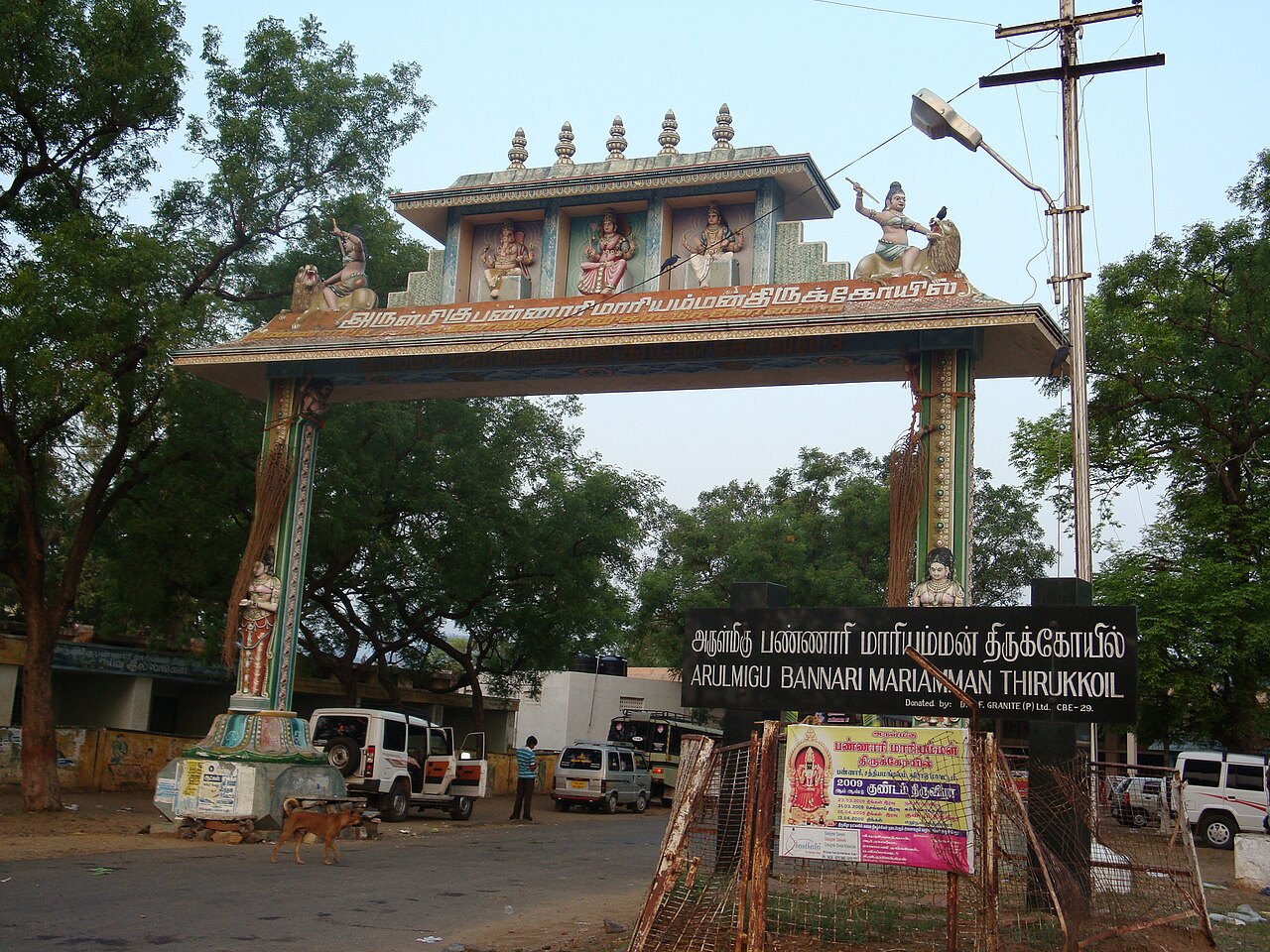
templeBannari Mariamman Temple
A prominent temple to Goddess Mariamman at Bannari on the foothills of the Western Ghats near Sathyamangalam, famous for the Panguni Kundam (fire-walking) festival that draws large crowds of devotees.
17.7 km · ~30 min by cab · straight line
damBhavanisagar Dam
The Lower Bhavani Dam, an earthen dam across the Bhavani river completed in 1956, one of the largest earthen dams in the world, with a large reservoir and riverside gardens.
26.4 km · ~44 min by cab · straight lineP
Pavalamalai Muthukumaraswamy Temple
Place
heritagePavalamalai Muthukumaraswamy Temple
The Muthukumaraswamy Temple on Pavalamalai hill near Gobichettipalayam is the second of the town's two Murugan hill shrines, the other being Pachaimalai. It sits on a small hill on the road toward Pariyur and is dedicated to Lord Murugan. It is a popular local pilgrimage climb offering views over the surrounding countryside.
28.7 km · ~48 min by cab · straight line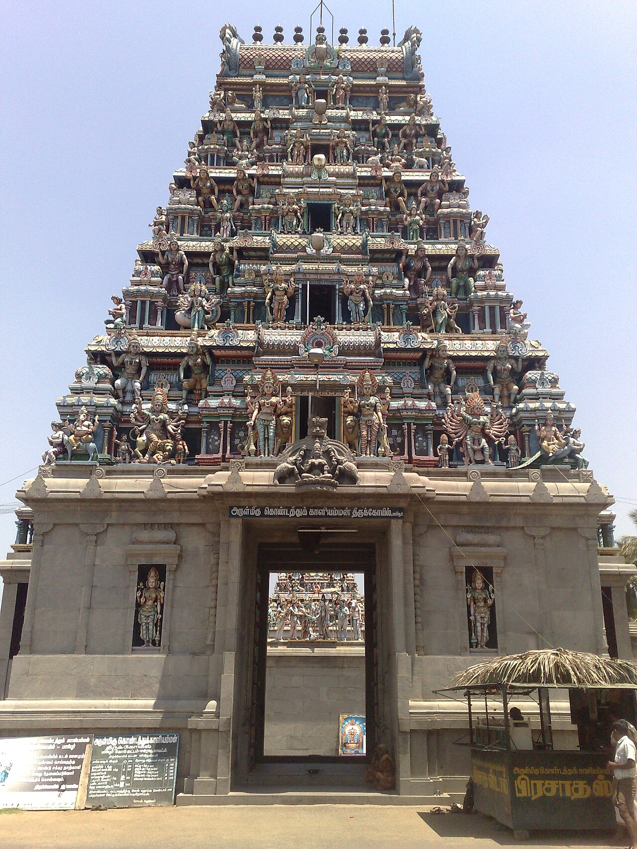
heritagePariyur Kondathu Kaliamman Temple
The Kondathu Kaliamman Temple at Pariyur is a widely revered shrine to the goddess Kaliamman, believed to be around 1,500 years old. It is known for its annual fire-walking ceremony held in January and a grand temple car festival that draws large crowds. Several shrines feature marble work, and the temple owns a golden chariot.
29.5 km · ~49 min by cab · straight lineA
Amarapaneeswarar Temple, Pariyur
Place
heritageAmarapaneeswarar Temple, Pariyur
The Amarapaneeswarar Temple at Pariyur is a Shiva temple dating to about the 10th century CE, with its consort worshipped as Soundaranayaki Amman. Originally built during the Chola period, it received later additions from the Pandya, Hoysala and Mysore rulers, and today is rebuilt almost entirely in white marble. Maha Shivaratri and Pradosham are celebrated here with particular grandeur.
29.7 km · ~49 min by cab · straight lineA
Anthiyur Lake and Waterfalls
Place
heritageAnthiyur Lake and Waterfalls
Anthiyur has a large irrigation lake whose overflow forms a seasonal waterfall dependent on rainfall in the Bargur Hills catchment. It is a local family spot used for fishing and swimming, most impressive during the monsoon months. The lake sits at the edge of the Anthiyur reserve forest belt.
33.7 km · ~56 min by cab · straight lineS
Sri Gurunatha Swamy Temple, Pudupalayam
Place
heritageSri Gurunatha Swamy Temple, Pudupalayam
Located at Pudupalayam near Anthiyur, this temple enshrines Gurunathaswami, worshipped through three sacred stones representing Kamakshi, Vishnu, and Shiva combined with Murugan. Legend holds the stones were once worshipped near Chidambaram, hidden in a river, and rediscovered at Pudupalayam, where a temple was built with Pandya patronage about 600 years ago. Its annual festival falls in the Tamil month of Aadi.
36.4 km · ~61 min by cab · straight lineU
Urachikottai Varadaraja Perumal Temple
Place
heritageUrachikottai Varadaraja Perumal Temple
This Vishnu temple sits on the Vedagiri hill at Urachikottai, about 5 km from Bhavani on the western bank of the Cauvery, and is regarded as the first of five hills known as the Panchagiri. Dedicated to Varadaraja Perumal, the temple is believed to be more than 1,000 years old. The hill is dotted with Saiva and Vaishnava shrines and overlooks the river.
52.1 km · ~87 min by cab · straight lineOn the map
Where Dhimbam Hills and Sathyamangalam Ghat Road is
Good to know
Dhimbam Hills and Sathyamangalam Ghat Road — frequently asked
When is the best time to visit Dhimbam Hills and Sathyamangalam Ghat Road?
October to March is the cooler, drier season in the Cauvery delta.
What are the entry fee and timings at Dhimbam Hills and Sathyamangalam Ghat Road?
Entry: Free (public road; forest checkpost timings apply). Timings: Daytime travel advised; forest road restrictions after dark.
How do I reach Dhimbam Hills and Sathyamangalam Ghat Road?
Base yourself in Thalavadi or nearby in Erode, then confirm the last-mile route locally before travel. If access depends on temple, museum or seasonal rules, check on the day before you go.
How much time do I need for Dhimbam Hills and Sathyamangalam Ghat Road?
About an hour.
What else is near Dhimbam Hills and Sathyamangalam Ghat Road?
Nearby you can pair Germalam Hills (11.3 km), Perumpallam Dam (11.9 km), Talavady Hills (13.1 km), Kunderipallam Dam (16.1 km).
Read before you go
Dhimbam Hills and Sathyamangalam Ghat Road guides, stories & itineraries
We have not published a story about Dhimbam Hills and Sathyamangalam Ghat Road itself yet. These cover Thalavadi and the wider district, with separate journeys between stops.
Tamil Nadu-wide guides & itineraries
Route-level itineraries and practical guides for the rest of Tamil Nadu.
Kasthuri Aranganathar Temple: story and tradition
Story & tradition
Kasthuri Aranganathar Temple: story and tradition
4 min read · Read →
Sri Gurunatha Swamy Temple, Pudupalayam: story and tradition
Story & tradition
Sri Gurunatha Swamy Temple, Pudupalayam: story and tradition
4 min read · Read →
The story of Pachaimalai Subramanya Swamy Temple
Place story
The story of Pachaimalai Subramanya Swamy Temple
4 min read · Read →
The story of Amarapaneeswarar Temple, Pariyur
Place story
The story of Amarapaneeswarar Temple, Pariyur
4 min read · Read →
The story of Kodumanal
Place story
The story of Kodumanal
4 min read · Read →
The story of Kunderipallam Dam
Place story
The story of Kunderipallam Dam
4 min read · Read →