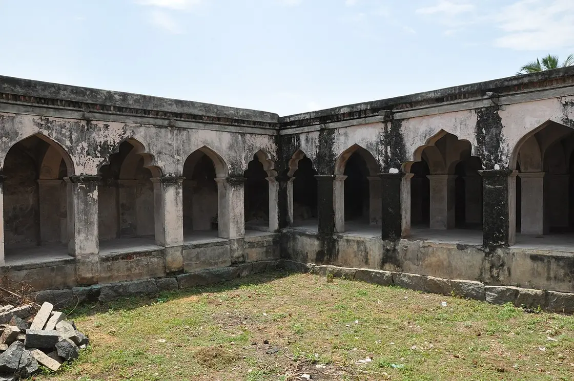
Attur Fort
A 17th-century fort on the southern bank of the Vasishta river, built by the Gatti Mudaliar Palaiyakkarar chieftains under the Madurai Nayaks. Protected by the river on the east and moats on the other sides, it later passed through Hyder Ali, Tipu Sultan and the British East India Company. It is now a protected monument of the state Archaeological Department.
Plan Attur Fort
Attur Fort is planned from Attur, one of the travel bases in Salem district. Use Attur for stays, food and local transport, then plan this place as a focused stop.
How to visit
- Base yourself in Attur or nearby in Salem, then confirm the last-mile route locally before travel.
- If access depends on temple, museum or seasonal rules, check on the day before you go.
Best time
October to March is the cooler, drier season in the Cauvery delta.
Live forecast loads in your browser.
Sun and moon are calculated for this location and shown in IST. Photography windows are the hour around sunrise and sunset; the sunset bearing is degrees clockwise from true north. Moon phase is accurate to about half a day.
Attur Fort in pictures
Stays, food & things to do near Attur Fort
Verified hotels, homestays, restaurants, experiences, sights, shops and rentals around Attur Fort — commission-free, with direct contact. Filter by what you need.
Verified places are being added. The category filters will fill in as approved stays, restaurants, experiences, sights, shops and nature listings go live.
List your placeTop experiences around Attur
One more place around Attur worth a day of its own.
27.6 km · ~46 min by cab
A range of the Eastern Ghats whose western Chinna Kalrayan section lies in Salem district around the Attur and Vazhapadi taluks, rising to around 1,000 m. The hills hold tribal settlements, small waterfalls and dams, and forested slopes, and are less commercialised than nearby Yercaud.
Roampedia is commission-free — own or know a stay, eatery, guide or shop near Attur Fort? List it and it appears here once verified.
Add a nearby businessAttur Fort — at a glance
Entry: Free
How to reach Attur Fort
About 56 km from Salem; nearest railway station Attur (~3 km); nearest airport Salem (SXV) ~55 km.
We have not assessed physical access at this place yet. Across India, step-free routes, handrails and accessible toilets are the exception rather than the rule, and pavements are often interrupted — if step-free access matters to you, contact the site or a local operator before committing to the trip.
Emergency numbers are verified against official government and state tourism sources. 112 works anywhere in India.
What’s near Attur Fort
Where Attur Fort is
Attur Fort — frequently asked
When is the best time to visit Attur Fort?
October to March is the cooler, drier season in the Cauvery delta.
What are the entry fee and timings at Attur Fort?
Entry: Free. Timings: Daylight hours.
How do I reach Attur Fort?
Base yourself in Attur or nearby in Salem, then confirm the last-mile route locally before travel. If access depends on temple, museum or seasonal rules, check on the day before you go.
How much time do I need for Attur Fort?
About an hour.
What else is near Attur Fort?
Nearby you can pair Aragalur Temples (21.1 km), Thanthondreeswarar Temple (23.5 km), Anaimaduvu Reservoir (26.8 km), Kalrayan Hills (27.6 km).
Attur Fort guides, stories & itineraries
We have not published a story about Attur Fort itself yet. These cover Attur, the town it sits in, and the wider district.
Tamil Nadu-wide guides & itineraries
Route-level itineraries and practical guides for the rest of Tamil Nadu.
Photographs: Thamizhpparithi Maari, CC BY-SA 3.0, via Wikimedia Commons (CC BY-SA 3.0), Thamizhpparithi Maari (CC BY-SA 3.0). Wikimedia Commons.
Image credits
- Attur Fort:Thamizhpparithi Maari, CC BY-SA 3.0, via Wikimedia Commons · CC BY-SA 3.0