What to expect
Kalrayan Hills
A range of the Eastern Ghats whose western Chinna Kalrayan section lies in Salem district around the Attur and Vazhapadi taluks, rising to around 1,000 m. The hills hold tribal settlements, small waterfalls and dams, and forested slopes, and are less commercialised than nearby Yercaud.

Practical guide
Plan Kalrayan Hills
Who's going?Tailor Kalrayan Hills to your trip
Typeheritage
Nearest baseAttur
DistrictSalem
Best timeOctober to March is the cooler, drier…
Time neededAbout an hour
EntryFree
Places to visit2→Kalrayan Hills is planned from Attur, one of the travel bases in Salem district. Use Attur for stays, food and local transport, then plan this place as a focused stop.
Getting there
How to visit
- Base yourself in Attur or nearby in Salem, then confirm the last-mile route locally before travel.
- If access depends on temple, museum or seasonal rules, check on the day before you go.
Timing
Best time
October to March is the cooler, drier season in the Cauvery delta.
Weather in Kalrayan HillsSeasonal guide
Live forecast loads in your browser.
Today at Kalrayan Hills
Sunrise6:05 am
Sunset5:57 pm
Golden hour best light4:57 pm–5:57 pm
Blue hour after sunset5:57 pm–6:22 pm
Sun sets toward compass bearingW · 261°
Moon tonight🌒 Waxing crescent · 24%
Sun and moon are calculated for this location and shown in IST. Photography windows are the hour around sunrise and sunset; the sunset bearing is degrees clockwise from true north. Moon phase is accurate to about half a day.
Photos
Kalrayan Hills in pictures
Stay · eat · do · rent · see · shop
Stays, food & things to do near Kalrayan Hills
Verified hotels, homestays, restaurants, experiences, sights, shops and rentals around Kalrayan Hills — commission-free, with direct contact. Filter by what you need.
Verified inventory is being added here.
Verified places are being added. The category filters will fill in as approved stays, restaurants, experiences, sights, shops and nature listings go live.
List your placeRanked guides
Top experiences around Attur
One more place around Attur worth a day of its own.
heritageAttur Fort
27.6 km · ~46 min by cab
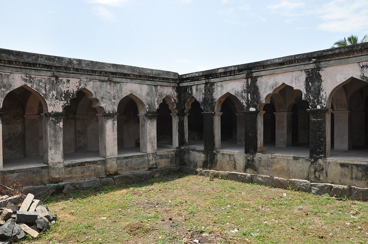
A 17th-century fort on the southern bank of the Vasishta river, built by the Gatti Mudaliar Palaiyakkarar chieftains under the Madurai Nayaks. Protected by the river on the east and moats on the other sides, it later passed through Hyder Ali, Tipu Sultan and the British East India Company. It is now a protected monument of the state Archaeological Department.
Roampedia is commission-free — own or know a stay, eatery, guide or shop near Kalrayan Hills? List it and it appears here once verified.
Add a nearby businessBefore you go
Kalrayan Hills — at a glance
TimingsOpen daylight hours
Best timeOctober to February
Entry: Free
Getting here
How to reach Kalrayan Hills
Reached via the Attur ghat road, about 70 km from Salem; nearest railway Attur (~30 km); nearest airport Salem (SXV) ~70 km.
Getting around Kalrayan Hills
If you need step-free access, contact the site before travelling. Ask about a level entrance, steps along the route, the nearest drop-off point, seating and accessible toilets.
If you need help at Kalrayan Hills
112All emergencies (police · fire · medical)The single number to call in any emergency (ERSS).100Police101Fire108Ambulance (emergency / EMS)1091Women’s helpline (distress)1098Child helpline1363Tourist helpline (India, 24×7, multilingual)
Emergency numbers are verified against official government and state tourism sources. 112 works anywhere in India.
Nearby
What’s near Kalrayan Hills
A
Anaimaduvu Reservoir
Place
heritageAnaimaduvu Reservoir
An irrigation reservoir near Belur set among low hills, used as a picnic and boating spot. It is one of the main water bodies among Salem's lakes and reservoirs and draws visitors during and after the monsoon.
23.4 km · ~39 min by cab · straight lineheritageAttur Fort
A 17th-century fort on the southern bank of the Vasishta river, built by the Gatti Mudaliar Palaiyakkarar chieftains under the Madurai Nayaks. Protected by the river on the east and moats on the other sides, it later passed through Hyder Ali, Tipu Sultan and the British East India Company. It is now a protected monument of the state Archaeological Department.
27.6 km · ~46 min by cab · straight lineT
Thanthondreeswarar Temple
Place
templeThanthondreeswarar Temple
A Shiva temple at Belur about 35 km from Salem, known for its varied stone sculptures. It is a heritage temple of the Salem-Belur belt.
28.8 km · ~48 min by cab · straight lineA
Aragalur Temples
Place
templeAragalur Temples
The town of Aragalur, about 74 km from Salem in the Gangavalli area, holds two old temples, Sri Kameswarar and Karivaradaperumal. Aragalur was a historic Chola-era settlement and its temples carry old inscriptions.
36.3 km · ~61 min by cab · straight line
wildlifeDeer Park
A small deer enclosure in Yercaud beside Emerald Lake, home to spotted deer and other small animals in a wooded setting. It is a family-friendly stop on the Yercaud circuit.
45.3 km · ~76 min by cab · straight line
templeServaroyan Temple
Servaroyan Temple is a compact cave shrine near Yercaud’s highest point, dedicated to Servarayan and set amid the upper Shevaroy Hills. The approach also offers expansive hill views when visibility is clear.
46.6 km · ~78 min by cab · straight line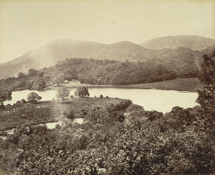
damEmerald Lake
A quiet lake in the Shevaroy Hills near Yercaud, ringed by coffee estates and adjacent to the Deer Park. Much less crowded than the main Yercaud Lake, it is a scenic stop on the Yercaud sightseeing circuit.
46.6 km · ~78 min by cab · straight line
parkBotanical Garden and Rose Garden
A government-run botanical garden in Yercaud with a dedicated rose collection amid the hill station's greenery.
46.9 km · ~78 min by cab · straight line
parkAnna Park
A small ornamental garden in Yercaud town known for its seasonal flower displays.
47.0 km · ~78 min by cab · straight line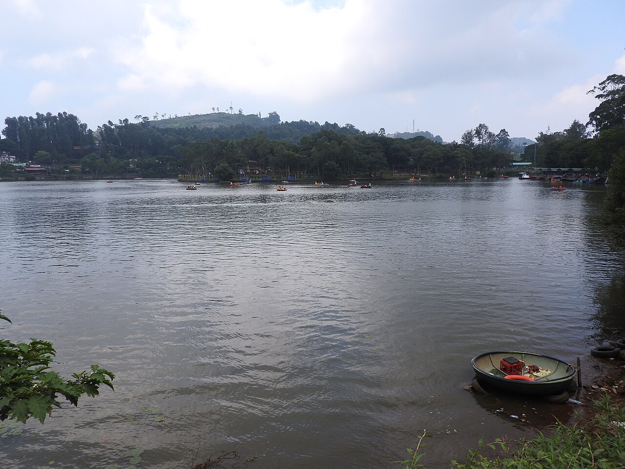
damYercaud Lake
A spring-fed boating lake at the heart of Yercaud hill station, surrounded by coffee and orange estates.
47.4 km · ~79 min by cab · straight line
viewpointShevaroy Hills
The range of hills in which Yercaud sits, known for coffee, orange and pepper estates and cool climate year-round.
47.8 km · ~80 min by cab · straight lineS
Silk Farm and Rose Garden
Place
parkSilk Farm and Rose Garden
A government sericulture demonstration farm with an adjoining rose garden a couple of kilometres from Yercaud town. Visitors can see the stages of silk production, and it is a common stop on the Yercaud sightseeing loop.
47.9 km · ~80 min by cab · straight lineOn the map
Where Kalrayan Hills is
Good to know
Kalrayan Hills — frequently asked
When is the best time to visit Kalrayan Hills?
October to March is the cooler, drier season in the Cauvery delta.
What are the entry fee and timings at Kalrayan Hills?
Entry: Free. Timings: Open daylight hours.
How do I reach Kalrayan Hills?
Base yourself in Attur or nearby in Salem, then confirm the last-mile route locally before travel. If access depends on temple, museum or seasonal rules, check on the day before you go.
How much time do I need for Kalrayan Hills?
About an hour.
What else is near Kalrayan Hills?
Nearby you can pair Anaimaduvu Reservoir (23.4 km), Attur Fort (27.6 km), Thanthondreeswarar Temple (28.8 km), Aragalur Temples (36.3 km).
Read before you go
Kalrayan Hills guides, stories & itineraries
We have not published a story about Kalrayan Hills itself yet. These cover Attur and the wider district, with separate journeys between stops.
Around Attur
These guides explore Attur and the surrounding area. Choose a visit that fits your interests, allowing separately for travel between stops.
Tamil Nadu-wide guides & itineraries
Route-level itineraries and practical guides for the rest of Tamil Nadu.
The story of Tharamangalam Kailasanathar Temple
Place story
The story of Tharamangalam Kailasanathar Temple
4 min read · Read →
The story of Deer Park
Place story
The story of Deer Park
4 min read · Read →
Deer Park: ecology and conservation story
Ecology & context
Deer Park: ecology and conservation story
4 min read · Read →
Image credits
Photographs: Thamizhpparithi Maari, CC BY-SA 4.0, via Wikimedia Commons (CC BY-SA 4.0), Manoj M Shenoy (CC BY-SA 4.0), PJeganathan (CC BY-SA 4.0). Wikimedia Commons.