What to expect
Ambur Fort
A 17th-century hill fort built by the Nawabs of Arcot overlooking Ambur town and the Palar valley, later held by Hyder Ali, Tipu Sultan and the British. It was the scene of the 1749 Battle of Ambur and the 1767 Siege of Ambur during the Carnatic Wars. Ruined ramparts, gateways and a moat survive as a landmark climb above the town.
A
Ambur Fort
Place
Practical guide
Plan Ambur Fort
Who's going?Tailor Ambur Fort to your trip
Typeheritage
Nearest baseAmbur
DistrictTirupathur
Best timeOctober to March is the cooler, drier…
Time neededAbout an hour
EntryFree
Places to visit2→Ambur Fort is planned from Ambur, one of the travel bases in Tirupathur district. Use Ambur for stays, food and local transport, then plan this place as a focused stop.
Getting there
How to visit
- Base yourself in Ambur or nearby in Tirupathur, then confirm the last-mile route locally before travel.
- If access depends on temple, museum or seasonal rules, check on the day before you go.
Timing
Best time
October to March is the cooler, drier season in the Cauvery delta.
Weather in Ambur FortSeasonal guide
Live forecast loads in your browser.
Today at Ambur Fort
Sunrise6:05 am
Sunset5:56 pm
Golden hour best light4:56 pm–5:56 pm
Blue hour after sunset5:56 pm–6:21 pm
Sun sets toward compass bearingW · 261°
Moon tonight🌒 Waxing crescent · 24%
Sun and moon are calculated for this location and shown in IST. Photography windows are the hour around sunrise and sunset; the sunset bearing is degrees clockwise from true north. Moon phase is accurate to about half a day.
Stay · eat · do · rent · see · shop
Stays, food & things to do near Ambur Fort
Verified hotels, homestays, restaurants, experiences, sights, shops and rentals around Ambur Fort — commission-free, with direct contact. Filter by what you need.
Verified inventory is being added here.
Verified places are being added. The category filters will fill in as approved stays, restaurants, experiences, sights, shops and nature listings go live.
List your placeRanked guides
Top experiences around Ambur
One more place around Ambur worth a day of its own.

townAmbur
1.1 km · 14 min walk
Palar-river town with a large leather-tanning and footwear industry, nationally famous as the home of Ambur biryani, a Nawab-of-Arcot-derived seeraga samba style.
Roampedia is commission-free — own or know a stay, eatery, guide or shop near Ambur Fort? List it and it appears here once verified.
Add a nearby businessBefore you go
Ambur Fort — at a glance
TimingsDaylight hours; best climbed early morning
Best timeNovember to February; avoid summer midday heat
Entry: Free
Getting here
How to reach Ambur Fort
In Ambur town; Ambur railway station ~2 km (Chennai-Bengaluru line, Jolarpettai junction ~20 km); Bengaluru airport (BLR) ~110 km
Getting around Ambur Fort
If you need step-free access, contact the site before travelling. Ask about a level entrance, steps along the route, the nearest drop-off point, seating and accessible toilets.
If you need help at Ambur Fort
112All emergencies (police · fire · medical)The single number to call in any emergency (ERSS).100Police101Fire108Ambulance (emergency / EMS)1091Women’s helpline (distress)1098Child helpline1363Tourist helpline (India, 24×7, multilingual)
Emergency numbers are verified against official government and state tourism sources. 112 works anywhere in India.
Nearby
What’s near Ambur Fort
townAmbur
Palar-river town with a large leather-tanning and footwear industry, nationally famous as the home of Ambur biryani, a Nawab-of-Arcot-derived seeraga samba style.
1.1 km · 14 min walk · straight line
townVaniyambadi
Palar-valley town that is one of Tamil Nadu's leading leather-tanning and leather-export centres, with a strong Muslim mercantile heritage, historic mosques and a biryani tradition allied to Ambur's.
15.6 km · ~26 min by cab · straight lineJ
Janab Masthan Ali Aulia Saheb Dargah, Vaniyambadi
Place
heritageJanab Masthan Ali Aulia Saheb Dargah, Vaniyambadi
A revered Sufi shrine in Vaniyambadi, a town with a large Muslim population and many mosques in medieval and modern Islamic styles. The dargah draws devotees across faiths and is cited as a symbol of the town's tradition of inter-religious coexistence.
15.7 km · ~26 min by cab · straight lineS
Sundara Varadaraja Perumal Temple, Vaniyambadi
Place
heritageSundara Varadaraja Perumal Temple, Vaniyambadi
A Vishnu temple on the banks of the Palar River and one of the main pilgrimage draws of Vaniyambadi. It stands opposite the Shiva shrine of Athitheeswarar, the paired temples flanking the river marking the old religious core of the town.
17.2 km · ~29 min by cab · straight lineA
Athitheeswarar Temple, Vaniyambadi
Place
heritageAthitheeswarar Temple, Vaniyambadi
An ancient Shiva temple on the banks of the Palar River, its origins traced to the Pallava period with additions by the Chola, Ganga and Vijayanagara dynasties. It carries inscriptions from the reigns of Rajaraja I, Rajendra I and Kulottunga Chola. Local legend links the town's name to Goddess Saraswati regaining her speech after worshipping Shiva here.
17.4 km · ~29 min by cab · straight lineA
Alangayam Dam
Place
heritageAlangayam Dam
A reservoir at Alangayam, a town panchayat in the western part of Tirupathur district near the Yelagiri and Javadi hill ranges. It is commonly listed among the district's scenic water-body attractions, set in an area known for sandalwood and agriculture.
18.8 km · ~31 min by cab · straight lineS
Swamimalai Hills, Yelagiri
Place
heritageSwamimalai Hills, Yelagiri
The highest point of the Yelagiri hill station, reached by a trek of roughly 3 km from Punganur Lake. The summit offers a panorama over the whole hill station and surrounding valleys, making it Yelagiri's best-known trekking route.
22.0 km · ~37 min by cab · straight lineN
Nilavoor Lake, Yelagiri
Place
heritageNilavoor Lake, Yelagiri
An artificial lake in Nilavoor village on the Yelagiri hills, flanked by a garden on its banks. It is a popular boating spot offering pedal and motorboat rides amid the hill scenery, and is quieter than the more central Punganur Lake.
23.0 km · ~38 min by cab · straight line
templeVelavan Temple, Yelagiri
Hillside temple dedicated to Lord Murugan (Velavan), one of the main devotional stops within the Yelagiri hill station, visited both for worship and for the valley views.
23.7 km · ~39 min by cab · straight lineG
Government Herbal Farm, Yelagiri
Place
heritageGovernment Herbal Farm, Yelagiri
A forest-department herbal park close to Punganur Lake growing medicinal herbs and plants used in Siddha and Ayurvedic preparations. It is a small educational nature stop showcasing the hill's rare medicinal flora.
23.8 km · ~40 min by cab · straight line
parkYelagiri Nature Park
Landscaped ~12-acre park near Punganur Lake with an artificial cascade, musical fountain, aquarium, children's play area and themed gardens; a standard family stop on the Yelagiri circuit.
24.0 km · ~40 min by cab · straight line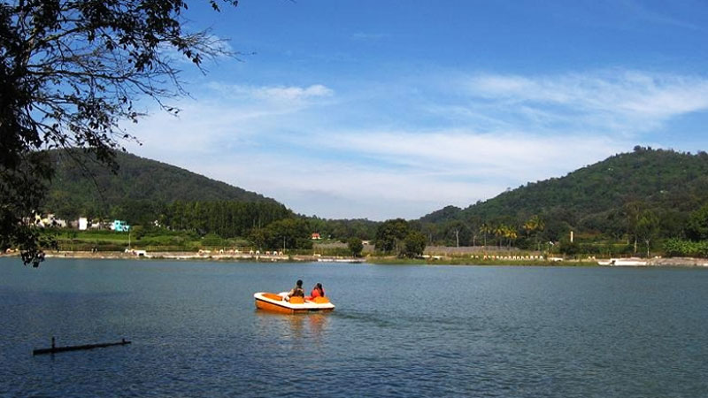
activityPunganur Lake
Man-made lake at the heart of Yelagiri, the hill station's most-visited spot, ringed by hills with a central fountain; pedal and row boating are the main draw.
24.6 km · ~41 min by cab · straight lineOn the map
Where Ambur Fort is
Good to know
Ambur Fort — frequently asked
When is the best time to visit Ambur Fort?
October to March is the cooler, drier season in the Cauvery delta.
What are the entry fee and timings at Ambur Fort?
Entry: Free. Timings: Daylight hours; best climbed early morning.
How do I reach Ambur Fort?
Base yourself in Ambur or nearby in Tirupathur, then confirm the last-mile route locally before travel. If access depends on temple, museum or seasonal rules, check on the day before you go.
How much time do I need for Ambur Fort?
About an hour.
What else is near Ambur Fort?
Nearby you can pair Ambur (1.1 km), Vaniyambadi (15.6 km), Janab Masthan Ali Aulia Saheb Dargah, Vaniyambadi (15.7 km), Sundara Varadaraja Perumal Temple, Vaniyambadi (17.2 km).
Read before you go
Ambur Fort guides, stories & itineraries
We have not published a story about Ambur Fort itself yet. These cover Ambur and the wider district, with separate journeys between stops.
Tamil Nadu-wide guides & itineraries
Route-level itineraries and practical guides for the rest of Tamil Nadu.
The story of Paiyampalli
Place story
The story of Paiyampalli
4 min read · Read →
Athitheeswarar Temple, Vaniyambadi: story and tradition
Story & tradition
Athitheeswarar Temple, Vaniyambadi: story and tradition
4 min read · Read →
The story of Nilavoor Lake, Yelagiri
Place story
The story of Nilavoor Lake, Yelagiri
4 min read · Read →
Nilavoor Lake, Yelagiri: history and local significance
History & significance
Nilavoor Lake, Yelagiri: history and local significance
4 min read · Read →
The story of Swamimalai Hills, Yelagiri
Place story
The story of Swamimalai Hills, Yelagiri
4 min read · Read →
Swamimalai Hills, Yelagiri: history and local significance
History & significance
Swamimalai Hills, Yelagiri: history and local significance
4 min read · Read →