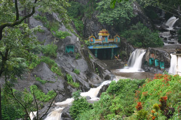
The waterfall is about forty feet high, which is not very high. What is remarkable is the sky above it. This stream falls through the catchment of Kigga, where the rain gauge recorded 6,968 millimetres in 2018 — close to seven metres of water in a year, among the highest totals in Karnataka — and five kilometres away stands the temple of the sage whom people petition when the rain does not come. Sirimane is a modest fall in an immoderate place.
The story of Sirimane Falls
Sirimane is the waterfall people drive to when they have finished at Sringeri, and it is worth being honest about its scale before you set off. The drop is generally given as about forty feet — twelve metres or so. It is not Jog Falls and nobody should go expecting it to be. What it is, is a broad tiered curtain of water sliding down a face of dark rock into a shallow boulder-strewn pool, with forest closing over the top of it, about fifteen and a half kilometres by road from Sringeri town at around 710 m.
The stream is a small tributary of the Tunga, and what happens to it after the fall is more useful than what happens at the fall. It runs on down through coffee estates and paddy fields, which is the ordinary economy of this part of the Malnad — this is not wilderness, it is worked country with a forest edge. Kigga, the village 5 km up the road, sits on the Nandini, another Tunga tributary. Everything here drains east into the same river that runs past the Sharadamba temple.
The site is managed rather than wild, and the management is light. There is a car park, a gate where a small charge is collected, toilets and changing rooms, a watch tower on the way down that gives you the fall in one frame, and a set of laid steps — around fifty of them — that take you from the car park to a viewing deck and on to the rocks at the base. That is the whole infrastructure. It means the falls are among the most genuinely accessible in the Western Ghats: there is no trek, no guide, no permit, and you can be at the bottom four or five minutes after locking the car.
Wikipedia adds a detail that we have not been able to confirm elsewhere and so attribute rather than assert: that a small hydraulic power plant stands beside the falls, generating electricity for the houses of Kigga, and that the entry money goes towards maintaining the walkways and viewpoints and supporting that plant. Its own article carries a warning that it needs more citations. If it is true it is a nice piece of arithmetic — a village lit by the same water people pay ten rupees to look at.
People bathe here, and you should understand what that means before you join them. There are changing rooms, which tells you it is expected and normal. But the base of the fall is loose boulders rather than sand, the rock is slick with algae, and the same catchment that makes the fall worth seeing turns the stream into something else entirely after a night of heavy rain. In spate the sensible thing is the viewing deck. District administrations across the Western Ghats issue advisories most monsoons asking visitors to stay away from waterfalls in heavy rain, and those advisories exist because people are swept off rocks every year.
The season question has two answers and they conflict, which is why most pages give you the wrong one. If you want water, come between July and October, when the fall is at full width and the noise fills the valley — and accept mud, leeches, cloud, and the risk that the base is roped off. If you want a comfortable, photographable, swimmable afternoon, come between late September and December. After December the flow drops away steadily, and by March there is not much to see. The fall does not dry up entirely, but it stops being a reason to drive fifteen kilometres.
What makes the trip worth it is not really the fall on its own — it is the fifteen kilometres. The road out of Sringeri climbs past the Tunga, through Kigga with its rain temple, and into forest that is genuinely thick, and the last stretch is narrow. Reviewers who arrive expecting a spectacle are often lukewarm; visitors who treat it as the destination at the end of a good drive, with a temple and a peak on the same road, come back happy. Take it as the second half of a Sringeri day and it earns its place.
Legend & myth
The legend belonging to this valley is about rain, and it sits five kilometres up the road at Kigga. The temple there is dedicated to Rishyashringa — Rishyashringeshwara — the horned sage of the Ramayana, and he is venerated specifically as a bringer of rain. When the monsoon fails in this part of Karnataka, this is where people go and this is who they ask. The story is that where the sage set foot on parched ground the clouds gathered and the drought broke.
The Ramayana version is the one the 1930 Mysore Gazetteer retells with some relish. Rishyashringa was born to the ascetic Vibhandaka and raised in the forest without ever having seen a woman. The kingdom of Anga lay under a drought, and its king was advised that only this untouched forest-born boy could break it. A party of young women was sent to fetch him; they made their first halt at Narve, a few miles from Sringeri, waited until the formidable father was away, and drew the boy out by degrees until curiosity carried him off to Anga — where the rain followed him. He later became priest to King Dasharatha and performed the sacrifice that produced Rama.
It is the same sage who gives Sringeri its name. The town is properly Rishyashringa-giri, the hill of Rishyashringa, and the hill and the hermitage are shown to visitors although nothing dates them. This is told as scripture and not as history, and we print it as scripture.
What is quietly striking is the geography of the belief. Rishyashringa is the deity you petition for rain, and his temple stands in one of the wettest places in India — a catchment that took nearly seven metres of rain in a single year. A drought god in a rainforest sounds like a contradiction until you have watched a Malnad farmer look at the sky in a bad June. Rain here is not a background condition; it is the whole crop, and when it comes late it comes late over coffee, areca and paddy that cannot wait.
Read the full history of Sirimane Falls 692 more words
History
There is no recorded history of this waterfall as such, and we are not going to manufacture one. It is a stream falling over a rock face in forest that has been worked for coffee, areca and paddy for a very long time; it has no inscription, no dynasty and no dated event attached to it. What can be said honestly is the history of the ground it falls in.
That ground belonged to the Sringeri math. The Sringeri jagir — the estate granted to the matha in 1346 by Harihara I of Vijayanagara and his brothers — is described in the Mysore Gazetteer of 1930 as about eight miles by six, with the Tunga running through it from south-west to north-east, and it was administered in imitation of the Mysore revenue system. It contained two hoblis, Sringeri and Melu-pala, with twenty-four villages and 9,264 people between them. Kigga is in that country. So the land around these falls was, for six centuries, monastery land.
The Gazetteer also notes the road: "There is also a road from Sringeri to Kigga." That is the road you now drive to the falls, and in 1930 it was worth listing because there were so few. The estate settlement that had held this arrangement together since the fourteenth century ended with Indian land reform in the 1960s and 1970s.
The falls themselves became a destination fairly recently, with the road. A first-hand account from August 2022 describes the approach roads as being in excellent condition after recent construction, which is a polite way of saying they had not been before. The car park, steps, watch tower, toilets and changing rooms are all modern additions of that same era of improvement, and the entry charge that pays for them has visibly climbed over the past decade.
One thing that has not changed is the rain, and it is worth putting a number on it because it explains everything else about this place. Sringeri town averages close to 3,950 mm a year. In 2018 the town recorded 4,981 mm, and Kigga hobli — the catchment this stream falls in — recorded 6,968 mm, among the highest totals anywhere in Karnataka that year. For four months of the year this is one of the wettest inhabited places in India.
Why visit
Go for the water between July and October, when the fall is at its full width and you can hear it before you can see it. This is when it earns the drive. Accept that you will be muddy, that leeches are a certainty in the surrounding forest, and that the base may be closed if the stream is in spate.
Go in late September to December if you want the version that is comfortable as well as good — decent flow, warm rock, and a base you can actually get down to and swim at without a fight. This is the sweet spot, and almost nobody tells you it is narrower than the whole post-monsoon season.
Go because it is easy, and genuinely so. Fifty laid steps from a car park to the foot of a waterfall, with a watch tower on the way and benches at the bottom, is a rare thing in the Western Ghats, where the good falls usually cost you a trek and a guide. If you are travelling with children or with someone who does not walk far, this is the Malnad waterfall to choose.
Go for the fifteen kilometres rather than the last hundred metres. The road climbs out of Sringeri along the Tunga and into thick forest, and it takes in Kigga on the way, where the Rishyashringa temple is the rain shrine of this district and the reason the whole valley has a name. Make the falls the end of that drive and not a stop on a checklist.
And go if you are already at Sringeri, which is the honest framing. This is a good half-day out from the math and a weak standalone destination from Bengaluru three hundred and fifty kilometres away. Paired with the Sharadamba and Vidyashankara temples in the morning, it makes a complete and unhurried day.