Sirimane Falls

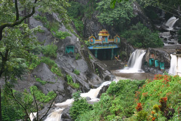
Sirimane Falls is a broad tiered waterfall of about 40 feet in forest above Kigga, 15.6 km by road from Sringeri at around 710 m. The stream is a small tributary of the Tunga; below the fall it runs on into coffee estates and paddy.

Sirimane Falls, Sringeri
Practical guide

Plan Sirimane Falls

Who's going?Tailor Sirimane Falls to your trip
Typewaterfall
Nearest baseSringeri
DistrictChikkamagaluru
Best timeJuly to October for full flow, late…
Time needed1 to 1.5 hours at the falls
Places to visit3Listed businesses10

It is not a big waterfall and it is honest to say so — the interest is the setting and the drive. What is remarkable is the rainfall: Sringeri town averages close to 3,950 mm a year, and in 2018 Kigga hobli, the catchment this stream falls in, recorded 6,968 mm, among the highest totals in Karnataka that year.

The site is lightly managed and unusually easy: a car park, a ticket gate, toilets and changing rooms, a watch tower on the way down, and around fifty laid steps to a viewing deck and the rocks at the base. No trek, no guide, no permit — which makes it the Malnad waterfall to choose if you are with children or with somebody who does not walk far.

Five kilometres back down the road at Kigga stands the temple of Rishyashringa, the sage of the Ramayana who gives Sringeri its name and who is worshipped here specifically as a bringer of rain, petitioned when the monsoon fails. A rain deity in one of the wettest inhabited places in India is the most interesting thing within ten kilometres of this waterfall.

The story

The waterfall is about forty feet high, which is not very high. What is remarkable is the sky above it. This stream falls through the catchment of Kigga, where the rain gauge recorded 6,968 millimetres in 2018 — close to seven metres of water in a year, among the highest totals in Karnataka — and five kilometres away stands the temple of the sage whom people petition when the rain does not come. Sirimane is a modest fall in an immoderate place.

The story of Sirimane Falls

Sirimane is the waterfall people drive to when they have finished at Sringeri, and it is worth being honest about its scale before you set off. The drop is generally given as about forty feet — twelve metres or so. It is not Jog Falls and nobody should go expecting it to be. What it is, is a broad tiered curtain of water sliding down a face of dark rock into a shallow boulder-strewn pool, with forest closing over the top of it, about fifteen and a half kilometres by road from Sringeri town at around 710 m.

The stream is a small tributary of the Tunga, and what happens to it after the fall is more useful than what happens at the fall. It runs on down through coffee estates and paddy fields, which is the ordinary economy of this part of the Malnad — this is not wilderness, it is worked country with a forest edge. Kigga, the village 5 km up the road, sits on the Nandini, another Tunga tributary. Everything here drains east into the same river that runs past the Sharadamba temple.

The site is managed rather than wild, and the management is light. There is a car park, a gate where a small charge is collected, toilets and changing rooms, a watch tower on the way down that gives you the fall in one frame, and a set of laid steps — around fifty of them — that take you from the car park to a viewing deck and on to the rocks at the base. That is the whole infrastructure. It means the falls are among the most genuinely accessible in the Western Ghats: there is no trek, no guide, no permit, and you can be at the bottom four or five minutes after locking the car.

Wikipedia adds a detail that we have not been able to confirm elsewhere and so attribute rather than assert: that a small hydraulic power plant stands beside the falls, generating electricity for the houses of Kigga, and that the entry money goes towards maintaining the walkways and viewpoints and supporting that plant. Its own article carries a warning that it needs more citations. If it is true it is a nice piece of arithmetic — a village lit by the same water people pay ten rupees to look at.

People bathe here, and you should understand what that means before you join them. There are changing rooms, which tells you it is expected and normal. But the base of the fall is loose boulders rather than sand, the rock is slick with algae, and the same catchment that makes the fall worth seeing turns the stream into something else entirely after a night of heavy rain. In spate the sensible thing is the viewing deck. District administrations across the Western Ghats issue advisories most monsoons asking visitors to stay away from waterfalls in heavy rain, and those advisories exist because people are swept off rocks every year.

The season question has two answers and they conflict, which is why most pages give you the wrong one. If you want water, come between July and October, when the fall is at full width and the noise fills the valley — and accept mud, leeches, cloud, and the risk that the base is roped off. If you want a comfortable, photographable, swimmable afternoon, come between late September and December. After December the flow drops away steadily, and by March there is not much to see. The fall does not dry up entirely, but it stops being a reason to drive fifteen kilometres.

What makes the trip worth it is not really the fall on its own — it is the fifteen kilometres. The road out of Sringeri climbs past the Tunga, through Kigga with its rain temple, and into forest that is genuinely thick, and the last stretch is narrow. Reviewers who arrive expecting a spectacle are often lukewarm; visitors who treat it as the destination at the end of a good drive, with a temple and a peak on the same road, come back happy. Take it as the second half of a Sringeri day and it earns its place.

Legend & myth

The legend belonging to this valley is about rain, and it sits five kilometres up the road at Kigga. The temple there is dedicated to Rishyashringa — Rishyashringeshwara — the horned sage of the Ramayana, and he is venerated specifically as a bringer of rain. When the monsoon fails in this part of Karnataka, this is where people go and this is who they ask. The story is that where the sage set foot on parched ground the clouds gathered and the drought broke.

The Ramayana version is the one the 1930 Mysore Gazetteer retells with some relish. Rishyashringa was born to the ascetic Vibhandaka and raised in the forest without ever having seen a woman. The kingdom of Anga lay under a drought, and its king was advised that only this untouched forest-born boy could break it. A party of young women was sent to fetch him; they made their first halt at Narve, a few miles from Sringeri, waited until the formidable father was away, and drew the boy out by degrees until curiosity carried him off to Anga — where the rain followed him. He later became priest to King Dasharatha and performed the sacrifice that produced Rama.

It is the same sage who gives Sringeri its name. The town is properly Rishyashringa-giri, the hill of Rishyashringa, and the hill and the hermitage are shown to visitors although nothing dates them. This is told as scripture and not as history, and we print it as scripture.

What is quietly striking is the geography of the belief. Rishyashringa is the deity you petition for rain, and his temple stands in one of the wettest places in India — a catchment that took nearly seven metres of rain in a single year. A drought god in a rainforest sounds like a contradiction until you have watched a Malnad farmer look at the sky in a bad June. Rain here is not a background condition; it is the whole crop, and when it comes late it comes late over coffee, areca and paddy that cannot wait.

Read the full history of Sirimane Falls 692 more words

History

There is no recorded history of this waterfall as such, and we are not going to manufacture one. It is a stream falling over a rock face in forest that has been worked for coffee, areca and paddy for a very long time; it has no inscription, no dynasty and no dated event attached to it. What can be said honestly is the history of the ground it falls in.

That ground belonged to the Sringeri math. The Sringeri jagir — the estate granted to the matha in 1346 by Harihara I of Vijayanagara and his brothers — is described in the Mysore Gazetteer of 1930 as about eight miles by six, with the Tunga running through it from south-west to north-east, and it was administered in imitation of the Mysore revenue system. It contained two hoblis, Sringeri and Melu-pala, with twenty-four villages and 9,264 people between them. Kigga is in that country. So the land around these falls was, for six centuries, monastery land.

The Gazetteer also notes the road: "There is also a road from Sringeri to Kigga." That is the road you now drive to the falls, and in 1930 it was worth listing because there were so few. The estate settlement that had held this arrangement together since the fourteenth century ended with Indian land reform in the 1960s and 1970s.

The falls themselves became a destination fairly recently, with the road. A first-hand account from August 2022 describes the approach roads as being in excellent condition after recent construction, which is a polite way of saying they had not been before. The car park, steps, watch tower, toilets and changing rooms are all modern additions of that same era of improvement, and the entry charge that pays for them has visibly climbed over the past decade.

One thing that has not changed is the rain, and it is worth putting a number on it because it explains everything else about this place. Sringeri town averages close to 3,950 mm a year. In 2018 the town recorded 4,981 mm, and Kigga hobli — the catchment this stream falls in — recorded 6,968 mm, among the highest totals anywhere in Karnataka that year. For four months of the year this is one of the wettest inhabited places in India.

Why visit

Go for the water between July and October, when the fall is at its full width and you can hear it before you can see it. This is when it earns the drive. Accept that you will be muddy, that leeches are a certainty in the surrounding forest, and that the base may be closed if the stream is in spate.

Go in late September to December if you want the version that is comfortable as well as good — decent flow, warm rock, and a base you can actually get down to and swim at without a fight. This is the sweet spot, and almost nobody tells you it is narrower than the whole post-monsoon season.

Go because it is easy, and genuinely so. Fifty laid steps from a car park to the foot of a waterfall, with a watch tower on the way and benches at the bottom, is a rare thing in the Western Ghats, where the good falls usually cost you a trek and a guide. If you are travelling with children or with someone who does not walk far, this is the Malnad waterfall to choose.

Go for the fifteen kilometres rather than the last hundred metres. The road climbs out of Sringeri along the Tunga and into thick forest, and it takes in Kigga on the way, where the Rishyashringa temple is the rain shrine of this district and the reason the whole valley has a name. Make the falls the end of that drive and not a stop on a checklist.

And go if you are already at Sringeri, which is the honest framing. This is a good half-day out from the math and a weak standalone destination from Bengaluru three hundred and fifty kilometres away. Paired with the Sharadamba and Vidyashankara temples in the morning, it makes a complete and unhurried day.

What to expect

Highlights

  • A broad tiered cascade of about 40 feet over dark rock, framed by forest.
  • A watch tower on the way down that frames the whole fall in one view.
  • Around fifty laid steps from the car park — no trek, no guide, no permit.
  • Changing rooms at the car park, which is what makes bathing practical here.
  • A catchment that recorded 6,968 mm of rain in 2018 — close to seven metres.
  • The Rishyashringa rain temple at Kigga, 5 km back down the road.
  • The drive itself: 15.6 km out of Sringeri along the Tunga and into thick forest.
  • The Narasimha Parvatha trek, which starts from near Kigga.
Getting there

How to visit

  • 15.6 km by road from the Sringeri KSRTC bus stand, about 19 minutes — and 5.0 km from Kigga. Routed 25 August 2026. Published figures range from 14 to 22 km because the straight line is only 8.4 km.
  • Generally open 8:00 AM to 6:00 PM with the gate closing at 6; one first-hand account gives 8:30 AM to 5:00 PM, so treat the earlier closing as the safe assumption late in the day.
  • A small charge is collected at the gate in cash, with a small parking charge. We print no figure — published amounts range from ₹5 to ₹50 across sources and years and none is authoritative. Carry small notes.
  • There is no bus for the last 5 km from Kigga. Without your own car, hire an auto or call taxi in Sringeri for the round trip and agree the waiting time up front — nothing idles at the gate.
  • Best for water July to October; best for the balance of flow and comfort late September to December. After December the flow drops away and by March there is little to see.
  • Wear shoes with grip, not smooth-soled sandals, and from June to September tuck your trousers into your socks against leeches.

Distance by road

  • Udupi79 km
  • Chikkamagaluru87 km
  • Mangaluru108 km
  • Mysuru265 km
  • Bengaluru324 km

Road km to Sringeri; ghat roads and traffic vary — allow extra.

Timing

Best time

July to October for full flow, late September to December for the best balance of water and comfort. After December the flow drops steadily. Avoid the base entirely when the stream is in spate after heavy rain.

Weather in Sirimane FallsSeasonal guide

Live forecast loads in your browser.

Today at Sirimane Falls
Sunrise6:18 am
Sunset6:40 pm
Golden hour best light5:40 pm–6:40 pm
Blue hour after sunset6:40 pm–7:05 pm
Sun sets toward compass bearingW · 278°
Moon tonight🌖 Waning gibbous · 61%
South-west monsoon. June to September brings heavy rain to Karnataka. Trails, falls and ghat roads can be slippery, swollen or closed at short notice, and forest departments sometimes suspend access. Check locally on the day before you travel.

Sun and moon are calculated for this location and shown in IST. Photography windows are the hour around sunrise and sunset; the sunset bearing is degrees clockwise from true north. Moon phase is accurate to about half a day.

Visitor notes

  • A lightly managed forest site with a ticket gate and steps — carry small cash, wear shoes with grip, and take your litter out with you.
Safety

Good to know

  • Wet rock is the main hazard and it is there nearly all year. The steps and the boulders at the base carry algae and are slippery even in fine weather — test your footing before you weight it.
  • Do not enter the water when the stream is high. After heavy rain the flow becomes genuinely dangerous and the base may be closed; every monsoon the Western Ghats district administrations advise visitors away from waterfalls, because people are swept off rocks each year.
  • The base is loose boulders, not sand, and there is no lifeguard, no rope and no supervision beyond the ticket gate.
  • Keep children within arm’s reach on the steps and at the base — neither has a continuous handrail or barrier.
  • Leeches are a certainty in the forest from June to September and for some weeks after. Harmless, but cover your ankles and do not pull one off by force.
  • Mobile coverage is weak to absent here. Do not count on calling for help, do not visit alone in the monsoon, and tell somebody your plan.
  • The road in is narrow, wet for four months of the year and shared with buses and estate vehicles that will not give way. Drive it in daylight.
  • There is no lighting on the steps and the canopy takes the light early — be back at the car park well before the 6:00 PM gate closing.
  • Parking is an unattended clearing in the trees. Take your valuables down with you.
  • Snakes are present in this forest as anywhere in the Malnad. Stay on the steps and cleared rock, and keep your hands out of crevices between boulders.
  • The nearest hospital is at Sringeri, about twenty minutes away; serious cases go on to Shivamogga or Mangaluru, each about an hour and a half further.
Stay · eat · do · rent · see · shop

Stays, food & things to do near Sirimane Falls

Verified hotels, homestays, restaurants, experiences, sights, shops and rentals around Sirimane Falls — commission-free, with direct contact. Filter by what you need.

1 place to eat near Sirimane Falls

S
Sri Bharathi Theertha Prasada (Annadana Hall)
Where to eat
Top pick
Dining hall
Sri Bharathi Theertha Prasada (Annadana Hall)

The math's free meal hall, which its own site says serves nitya annadana to around 7,500 people a day. Lunch runs 12:15 to 2:30 and supper 7:15 to 8:30. Vegetarian, no charge, and open to every visitor — for most pilgrims this is where they eat in Sringeri.

Directions Commission-freeView details

Book with the place itself. India’s cyber-crime coordination centre warned in April 2025 that convincing copies of hotel and pilgrimage booking sites are being pushed through sponsored search and social ads, taking payment for rooms the property never hears about. Every listing here links to the business’s own contact details and its own Google or Bing profile — we take no commission and sit in nobody’s payment path. If a booking page reached you through an ad, check the address bar against the property’s own site before you pay. Fraud can be reported on cybercrime.gov.in or on 1930.

Ranked

The best of Sringeri, ranked

Sirimane Falls sits in Sringeri, and these rank everything verified across the town rather than this one spot — built from the same listings shown above, ordered by the strength of the source evidence behind each entry rather than by anyone's star score. Every card shows how many places are really on it. Nobody pays to appear.

Across the whole of Sringeri

Ranked guides

Top experiences around Sringeri

2 more places around Sringeri, each worth a day of its own.

templeSharadamba Temple, Sringeri

14.0 km · 15 min drive

The temple of goddess Sharadamba at Sringeri, seat of the Sharada Peetham — the first of the four mathas founded by Adi Shankaracharya — on the bank of the Tunga river; a major centre of learning and pilgrimage.

templeVidyashankara Temple, Sringeri

14.0 km · 15 min drive

A 14th-century temple in the Sringeri math complex blending Hoysala and Vijayanagara styles, famous for its twelve zodiac pillars set so that sunlight falls on the pillar of the solar month, and for its finely carved outer walls.

Roampedia is commission-free — own or know a stay, eatery, guide or shop near Sirimane Falls? List it and it appears here once verified.

Add a nearby business
Before you go

Sirimane Falls — at a glance

TimingsCommonly published as 8:00 AM to 6:00 PM, with the gate closing at 6:00 PM. One first-hand account from 2022 gives 8:30 AM to 5:00 PM, and if you are arriving late in the day that is the safer assumption to plan against. Do not aim to be at the base near dusk in any case: this is closed forest, the canopy takes the light early, and the walk back up the steps is the part you want to do while you can see it. Timings tighten or the base is closed outright when the stream is in spate after heavy rain.
Best timeThere are two right answers and they conflict, which is why most pages give you the wrong one. For water, come July to October, during and just after the south-west monsoon, when the fall runs at full width and you hear it before you see it — and accept mud, cloud, leeches and the real possibility that the base is roped off. For the best balance of flow and comfort, come late September to December: good volume, warm rock, a base you can get down to, and skies you can photograph in. After December the flow drops away steadily and by March there is not much left; the fall never dries completely but it stops being worth fifteen kilometres. Put a number on the rain, because it explains this place: Sringeri town averages close to 3,950 mm a year, and in 2018 Kigga hobli — the catchment this stream falls in — recorded 6,968 mm, among the highest totals in Karnataka that year.

Entry: A small charge is collected at a gate on the way in, together with a small parking charge, and it goes towards the steps, walkways and viewpoints. We deliberately print no figure, because the published ones do not agree: ₹5, ₹10, ₹20 for an adult with ₹10 for a child, and ₹50 per adult in a dated first-hand account from 2022 have all been reported, and there is no official page that settles it. What is safe to say is that it is tens of rupees rather than hundreds, that it has risen steadily over the past decade, and that you should carry small cash — this is a forest gate, not a ticket office with a card machine.

Dress code: None — this is forest, not a temple. Dress for the practical problems instead. Footwear with grip matters more than anything else you bring, because the steps and the rocks at the base are wet and algae-slick for most of the year, and smooth-soled sandals are the commonest way people fall here. If you intend to get in the water, wear or carry something you can swim in and use the changing rooms at the car park rather than improvising. From June to September add full-length trousers you can tuck into socks, against leeches, and something waterproof for yourself and for your phone. Bring a dry change and a bag for the wet one — you will be sitting in a car afterwards.

Festivals: Nothing at the falls themselves. The festival life of this valley belongs to the temples: the Rishyashringa temple at Kigga, 5 km away, is the rain shrine of the district and is petitioned in droughts, and Sringeri's own great festival is Sharada Navaratri in September or October, which fills the whole area completely and makes both the road and the falls busier than usual. Weekends and public holidays through the post-monsoon season are the practical crowd peaks here. All the temple dates move with the lunar calendar and we do not print fixed ones; the Sringeri math's administration office on +91-8265-252525 will confirm.

Photography: A good and forgiving subject, and unusually easy to shoot because the watch tower on the way down gives you the whole fall in one frame without a scramble. The tiered shape means a slow shutter works beautifully — bring something to rest the camera on, because the light under the canopy is low and a tripod is more use here than a fast lens. Early morning has the best light and the fewest people; by late morning at weekends in season there will be visitors in every frame at the base. Spray is the practical enemy: in full monsoon flow the air near the bottom is wet enough to fog a lens in a minute, so carry a cloth and keep the front element covered until you shoot. Watch your footing before you watch your framing — the rocks at the base are slick. No drones over the forest.

Parking: There is a proper car park at the top of the steps, and a small parking charge is collected with the entry ticket. It is the ordinary Malnad arrangement — a levelled area in the trees rather than a marked lot — and it fills on weekends and public holidays in season, when cars end up along the approach road. Arrive before mid-morning at those times. Nothing is formally attended, so take your valuables down with you; the changing rooms are for changing, not for leaving bags in. There is no fuel here and none at Kigga worth relying on: fill up in Sringeri town, which has HP, BP and IOCL outlets, before you come out.

Getting here

How to reach Sirimane Falls

  • ✈︎ By air Mangaluru International Airport (IXE) at Bajpe is the nearest, 101.6 km by routed road and about an hour and twenty-five minutes, measured 25 August 2026. It is the sensible arrival point for most visitors, with domestic flights across India and a handful of Gulf routes. Kempegowda International at Bengaluru (BLR) is 352.4 km and the better part of five hours of ghat driving — treat that as a two-stage journey, not a day trip. There is no airstrip anywhere near Sringeri. Hire a car at whichever airport you land at, because there is nothing waiting at this end and no app cabs operate here.
  • 🚆︎ By train There is no railway station at Sringeri or Kigga and nothing close. Udupi (UD) on the Konkan Railway is the nearest at 85.7 km and about an hour and twenty minutes by road from the falls, and it is the one to aim for from Mumbai, Goa or Kerala. Shimoga Town (SMET) is 120.1 km and about an hour and forty, and is the natural choice from Bengaluru and the interior. Mangaluru Central is a similar distance to the airport. Useful local detail: the post office in Sringeri town has a railway booking facility, which saves a long detour if you need to change a return.
  • 🚗︎ By road This is the only way in and the road is half the point. From Sringeri the route runs out along the Tunga and climbs through Kigga into thick forest — 15.6 km and about nineteen minutes of driving, though allow longer, because the last stretch is narrow and you will want to stop. Approach-road surfaces were substantially rebuilt in the years around 2022 and a first-hand account from August of that year describes them as excellent; by Malnad standards that holds up. From Chikkamagaluru it is 102.4 km and about an hour and thirty-five; from Udupi 85.7 km and an hour and twenty, by way of Agumbe; from Mangaluru airport 101.6 km; from Shimoga 120.1 km; from Bengaluru 352.4 km and the better part of five hours. The Agumbe ghat on the coastal approach is beautiful and demanding — tight hairpins through rainforest, slow and occasionally closed by landslip in the monsoon. Drive all of these in daylight.
  • 🚌︎ By bus There is no bus to the falls. KSRTC and private services run into Sringeri from Bengaluru, Mangaluru, Udupi, Mysuru, Shivamogga, Chikkamagaluru, Dharmasthala, Kollur and Koppa, and local buses run out to Kigga, but the last five kilometres from Kigga to the gate are not served. Without your own vehicle the realistic arrangement is an auto-rickshaw or a call taxi from Sringeri town negotiated for the round trip with waiting time agreed up front — do not expect to find a ride back from the falls, because there is nothing idling there. Reckon on about eight hours from Bengaluru to Sringeri by bus, four from Mangaluru or Dharmasthala, two and a half from Udupi, three from Shivamogga or Chikkamagaluru, and an hour from Koppa.
  • ⛴︎ By boat None, and none is possible. The stream here is a small tributary of the Tunga running over rock, a few metres wide — there is no navigable water anywhere near the falls and no boat service of any kind in this part of the district.
Getting back

Work out your return before you settle in for the sunset. Public transport here thins out sharply in the evening, and Sirimane Falls is easier to reach than to leave. We do not publish departure times: there is no official live feed we are permitted to republish, and a wrong time here would strand you. Check the operator directly on the day.

Ask at the jetty or stand for the time of the last service back, not the next one. If you miss it, an auto or app cab is the fallback — agree the fare before you get in.

Do

Things to do

  • Stop at the watch tower on the way down rather than walking straight past it. It frames the whole fall in one view, which you cannot get from the base, and it is the best photograph on the site.
  • Go on down the steps to the rocks at the foot of the fall and sit for a while. The noise in full flow is the thing people remember, and it is worth ten quiet minutes rather than a photograph and a turn back up.
  • Get in the water if the flow is moderate and the base is open — that is what the changing rooms at the car park are there for. Wear something with grip on your feet and test each rock before you weight it.
  • Look at where the water goes. The stream runs on into coffee estates and paddy below, and the worked country downstream is as much a part of this landscape as the forest above it.
  • Stop at Kigga on the way, 5 km back down the road, for the Rishyashringa temple — the rain shrine of this district, dedicated to the sage who gives Sringeri its name and who is petitioned when the monsoon fails.
  • Give the drive itself the time it deserves. The road from Sringeri climbs along the Tunga and through genuinely thick forest, and it is a better piece of the day than the last hundred metres.
  • Pair the trip with the Sharadamba and Vidyashankara temples at Sringeri in the morning. Temples first while it is cool, falls in the afternoon, is the right order.
  • If you are a serious walker, the Narasimha Parvatha trek starts from near Kigga and is one of the harder climbs in the district. Visitors report that a guide is required; treat it as a separate day, not an add-on.
  • Carry your rubbish out. There is no meaningful waste collection at a forest gate and this stream feeds farmland a few kilometres downstream.
Plan

Good to know

  • Come early. Before mid-morning you will have the base more or less to yourself; by lunchtime at a weekend in season there are people in every frame.
  • Wear shoes with grip, and not smooth-soled sandals. Wet algae on rock is the single commonest way people get hurt here.
  • Carry small cash. The gate charge and the parking charge are both small and collected in notes; there is no card machine in the forest.
  • From June to September, tuck your trousers into your socks. Leeches are a certainty in the surrounding forest and unpleasant rather than dangerous.
  • Bring a dry change of clothes and a bag for the wet ones, whether or not you plan to swim. Between the spray and the rain you will not stay dry in season.
  • Do not rely on your phone. Coverage here is weak to absent — download the map before you leave Sringeri and tell somebody where you are going.
  • Fill the tank and draw cash in Sringeri town before you drive out. There is nothing dependable beyond it on this road.
  • Check the sky, not the calendar. After a night of heavy rain the stream can be in spate and the base closed, whatever the season says.
  • Allow more driving time than fifteen kilometres suggests. This is a narrow forest road, not a highway, and nineteen minutes is the optimistic version.
  • Do the temples first and the falls second. Sringeri's temples close in the middle of the day and the falls do not.
Facilities

On site

  • Car park at the top of the steps, with a small parking charge collected alongside the entry ticket.
  • Ticket gate on the approach — small cash only.
  • Toilets at the car park.
  • Changing rooms at the car park, which is what makes bathing practical here.
  • A watch tower on the way down, giving the best single view of the fall.
  • Around fifty laid steps from the car park to the viewing deck and the base — no continuous handrail.
  • Benches near the falls.
  • Refreshments in season near the entrance; nothing you should depend on out of season.
  • No lifeguard, no supervision at the water, and no lighting on the steps.
  • Weak to absent mobile coverage.
  • No fuel here or at Kigga worth relying on — the nearest dependable pumps are in Sringeri town (HP, BP, IOCL).
  • Homestays around Kigga and in the surrounding estates; the Sringeri math's own guest houses are 15 km away in the town.
  • Sharada Dhanvantari Charitable Hospital at Sringeri, about 4 km from the math, with out-patients, a laboratory, ECG and specialists.
Stay safe

Safety

  • Wet rock is the main hazard and it is present nearly all year. The steps and the boulders at the base carry algae and are slippery even when the weather looks fine — take them slowly and test your footing before you commit weight.
  • Do not go into the water when the stream is high. After heavy rain the flow becomes genuinely dangerous, the base may be closed, and district administrations across the Western Ghats issue advisories every monsoon asking visitors to stay away from waterfalls. Those advisories exist because people are swept off rocks every year.
  • The base is loose boulders, not sand. There is no lifeguard, no rope and no supervision beyond the ticket gate — you are responsible for your own judgement here.
  • Keep children within arm's reach on the steps and at the base. Neither has a continuous handrail or barrier.
  • Leeches are a certainty in the forest from June to September and for some weeks after. They are harmless. Cover your ankles, and do not pull one off by force.
  • Mobile coverage is weak to absent at the falls. You cannot count on calling for help, so do not visit alone in the monsoon and tell somebody your plan.
  • The road in is narrow, wet for four months of the year and shared with buses and estate vehicles that will not give way. Drive it in daylight; the ghat approaches from the coast are subject to landslip in the monsoon.
  • There is no lighting on the steps and the canopy takes the light early. Be back at the car park well before the 6:00 PM gate closing.
  • Do not leave valuables in the car. Parking is a levelled clearing in the trees and is not attended.
  • Snakes are present in this forest, as anywhere in the Malnad. Stay on the steps and the cleared rock rather than pushing into vegetation, and do not put your hands into crevices between boulders.
  • The nearest hospital is the Sharada Dhanvantari Charitable Hospital at Sringeri, about 4 km from the math and therefore roughly twenty minutes from the falls. Serious cases go on to Shivamogga or Mangaluru, each around an hour and a half further.
Getting around Sirimane FallsNot wheelchair accessible
Terrain
Some steps
Steps
A flight of laid steps from the car park down to the viewing deck and on to the rocks at the base — visitor accounts consistently report around fifty, and we print that as their count rather than ours, because we have not been on the ground. They are properly built and even, which is more than most falls in this district offer, but there is no continuous handrail and they carry algae and are slippery for most of the year. The last few metres onto the rocks at the foot of the fall are not steps at all but loose boulders, and that is the part where people actually come to grief.
From the entrance
Short and easy as far as the top of the steps. There is a car park at the head of the path, a ticket gate on the way in, and the walk from car to viewing deck takes four or five minutes at an unhurried pace. Everything difficult about this site is below the deck, not above it.
Step-free access
Not accessible, and we would rather say so plainly than have somebody drive fifteen kilometres of forest road to find out. The falls are reached only by a flight of about fifty steps with no ramp, no lift and no alternative route that we can find, and the base is loose boulders. What IS possible: the car park itself is level ground and a wheelchair user can be driven right to it, and the setting — forest, the sound of the fall, the drive out from Sringeri — is a real thing even from the top. But there is no view of the waterfall from the car park, and the watch tower that gives the best view is down the steps. If step-free water is what you want in this district, this is not the site for it.
Prams
A carrier, not a pram. The car park is fine and the top of the path is fine, but a pram cannot go down fifty steps and there is nowhere supervised to leave one. With a small child, carry them — and hold onto them at the bottom, where the boulders are slick and there is no barrier between the rocks and the water.

Car park at the top of the steps, on level ground, with a small parking charge collected with the ticket.Toilets at the car park.Changing rooms at the car park — the reason bathing is practical here at all.A watch tower on the way down, giving the best single view of the fall; reached by steps.Benches near the falls.No ramp, no lift and no step-free route to the deck or the base that we can find.No continuous handrail on the steps.No lifeguard and no supervision at the water.No lighting on the steps; the canopy takes the light early and the gate closes at 6:00 PM.We could not establish whether any toilet here is an accessible one, and we are not going to assume so.Mobile coverage is weak to absent — you cannot count on calling for help.Sharada Dhanvantari Charitable Hospital at Sringeri, roughly twenty minutes away by road.

  • Algae on wet rock is the main hazard, on the steps and worse at the base. It is present nearly all year, not only in the monsoon.
  • The base is loose boulders with no barrier and no rope. In spate it may be closed outright, and every monsoon the Western Ghats district administrations advise visitors away from waterfalls, because people are swept off rocks.
  • No continuous handrail on the steps, which matters most on the way back UP if you are tired, wet or carrying a child.
  • Leeches are a certainty in the surrounding forest from June to September — harmless, unpleasant, and worse if you are slow on your feet.
  • Weak to absent mobile coverage. Do not visit alone in the monsoon.
  • Getting here is harder than being here: fifteen kilometres of narrow forest road from Sringeri, no bus for the last five kilometres from Kigga, and nothing idling at the gate for a ride back.

Checked 25 August 2026 against source 1source 2source 3. Conditions change and surfaces vary with weather — if step-free access is essential, confirm with the site before you travel.

If you need help at Sirimane Falls
112All emergencies (police · fire · medical)The single number to call in any emergency (ERSS).

Emergency numbers are verified against official government and state tourism sources. 112 works anywhere in India.

Nearby

What’s near Sirimane Falls

waterfallHanuman Gundi Falls 38.0 km · 33 min drive
wildlifeBhadra Wildlife Sanctuary 51.9 km · ~86 min by cab · straight line
trekKudremukh Peak 80.2 km · 102 min drive
heritageHirekolale Lake 92.5 km · 97 min drive
trekMullayanagiri 103.2 km · 119 min drive
waterfallKalhattigiri Falls 157.7 km · 148 min drive
hill stationBaba Budangiri 189.8 km · 195 min drive
waterfallManikyadhara Falls 190.2 km · 194 min drive

All 3 places to visit in Sringeri →

Walking and driving times are real routed distances, except the few marked “straight line”, which are direct-line estimates and will read short. Routing: © openrouteservice.org by HeiGIT | Map data © OpenStreetMap contributors

On the map

Where Sirimane Falls is

Good to know

Sirimane Falls — frequently asked

How far is Sirimane Falls from Sringeri, and how long does it take?

About 15.6 km by road from the Sringeri KSRTC bus stand, and roughly 19 minutes of driving — we routed it on 25 August 2026. Published figures vary between 14 and 22 km and you will see all of them; the uploader of one of our own photographs puts it at 14 km. The straight-line distance is only 8.4 km, which is why some listings quote a much shorter figure than you will actually drive. From Kigga it is 5.0 km, and from the Rishyashringa temple at Kigga 4.5 km.

How high is the waterfall?

About 40 feet, or roughly 12 metres, as it is generally reported. It is a broad tiered fall rather than a single tall plunge, and it is not in the league of Jog Falls. Go for the setting and the drive rather than the height.

What is the entry fee?

A small charge collected at the gate, and we deliberately do not print a single figure because the published ones do not agree. Across sources and years we have seen ₹5, ₹10, ₹20 for an adult with ₹10 for a child, and ₹50 per adult in a dated first-hand account from 2022, plus a small parking charge. It has clearly risen over the past decade and there is no official page to settle it. Carry small cash and expect tens of rupees, not hundreds.

What are the timings?

Commonly published as 8:00 AM to 6:00 PM, with the gate closing at 6. One first-hand account from 2022 gives 8:30 AM to 5:00 PM. Treat the earlier closing as the safe assumption if you are arriving late in the day, and do not plan to be at the bottom near dusk — this is forest, and the light goes quickly under the canopy.

Can I swim or bathe at the falls?

People do, and there are changing rooms at the car park, which tells you it is normal and expected. But be careful about it rather than casual: the base is loose boulders, not sand, the rock is slippery with algae, and in heavy rain the stream becomes genuinely dangerous. In spate the base may be closed and the viewing deck is the right answer. Every monsoon the district administrations in the Western Ghats ask visitors to stay away from waterfalls in heavy rain, and those advisories exist because people are swept off rocks.

How hard is the walk from the car park?

Easy — this is one of the most accessible waterfalls in the region. Around fifty laid steps take you down from the parking area past a watch tower to a viewing deck, and on to the rocks at the base. There is no trek, no guide and no permit. The steps have no continuous handrail and are slick when wet, which is the only real difficulty.

When is the best time to visit?

Two answers, and they conflict. For water: July to October, when the fall is at full width — with mud, cloud and leeches as the price. For the best balance of flow and comfort: late September to December. After December the flow drops steadily and by March there is little to see. The fall does not vanish, but it stops being worth the drive.

What facilities are there?

A car park, a ticket gate, toilets and changing rooms, a watch tower on the way down, benches near the falls, and refreshments in season. That is all of it, and it is more than most falls in the Ghats have. Mobile coverage is weak to absent here, so do not rely on being able to call anybody.

Are there leeches?

Yes, reliably, from June to September and for some weeks after. They are harmless and unpleasant. Cover your ankles, tuck your trousers into your socks, and check yourself when you get back to the car. Salt or a lit match is the traditional remedy; do not pull one off by force.

What else is on the same road?

Kigga, 5 km away, with the Rishyashringa temple — the rain shrine of this district, dedicated to the sage who gives Sringeri its name. The Narasimha Parvatha trek starts from near Kigga and is one of the harder climbs in the district; visitors report that a guide is required. And Sringeri itself, with the Sharadamba and Vidyashankara temples, is the obvious other half of the day.

Where does the water go?

Downhill into coffee estates and paddy fields, and eventually into the Tunga — the stream is one of its small tributaries, as is the Nandini that Kigga sits on. Wikipedia additionally reports that a small hydraulic power plant beside the falls generates electricity for the houses of Kigga, and that entry money helps support it; we flag that as reported rather than verified, because that article carries its own warning that it needs more citations.

What does the name mean?

We could not find a source that explains it, and we are not going to invent one. In Kannada "siri" is wealth or prosperity and "mane" is a house, so the name reads naturally as something like "house of prosperity" — but nobody we could find actually derives it that way, and a plausible reading is not an etymology.

Is it worth coming all the way from Bengaluru?

Not on its own. It is about 350 km and the better part of five hours each way, for a forty-foot waterfall. As part of a Sringeri trip — the temples in the morning, the falls and Kigga in the afternoon — it is excellent. Judge it as the second half of a day, not as a destination.

When is the best time to visit Sirimane Falls?

July to October for full flow, late September to December for the best balance of water and comfort. After December the flow drops steadily. Avoid the base entirely when the stream is in spate after heavy rain.

What are the entry fee and timings at Sirimane Falls?

Entry: A small charge is collected at a gate on the way in, together with a small parking charge, and it goes towards the steps, walkways and viewpoints. We deliberately print no figure, because the published ones do not agree: ₹5, ₹10, ₹20 for an adult with ₹10 for a child, and ₹50 per adult in a dated first-hand account from 2022 have all been reported, and there is no official page that settles it. What is safe to say is that it is tens of rupees rather than hundreds, that it has risen steadily over the past decade, and that you should carry small cash — this is a forest gate, not a ticket office with a card machine.. Timings: Commonly published as 8:00 AM to 6:00 PM, with the gate closing at 6:00 PM. One first-hand account from 2022 gives 8:30 AM to 5:00 PM, and if you are arriving late in the day that is the safer assumption to plan against. Do not aim to be at the base near dusk in any case: this is closed forest, the canopy takes the light early, and the walk back up the steps is the part you want to do while you can see it. Timings tighten or the base is closed outright when the stream is in spate after heavy rain.

How do I reach Sirimane Falls?

15.6 km by road from the Sringeri KSRTC bus stand, about 19 minutes — and 5.0 km from Kigga. Routed 25 August 2026. Published figures range from 14 to 22 km because the straight line is only 8.4 km. Generally open 8:00 AM to 6:00 PM with the gate closing at 6; one first-hand account gives 8:30 AM to 5:00 PM, so treat the earlier closing as the safe assumption late in the day. A small charge is collected at the gate in cash, with a small parking charge. We print no figure — published amounts range from ₹5 to ₹50 across sources and years and none is authoritative. Carry small notes. There is no bus for the last 5 km from Kigga. Without your own car, hire an auto or call taxi in Sringeri for the round trip and agree the waiting time up front — nothing idles at the gate. Best for water July to October; best for the balance of flow and comfort late September to December. After December the flow drops away and by March there is little to see. Wear shoes with grip, not smooth-soled sandals, and from June to September tuck your trousers into your socks against leeches.

How much time do I need for Sirimane Falls?

1 to 1.5 hours at the falls; half a day from Sringeri with the Rishyashringa temple at Kigga on the way.

What else is near Sirimane Falls?

Nearby you can pair Sharadamba Temple, Sringeri (14.0 km), Vidyashankara Temple, Sringeri (14.0 km), Hanuman Gundi Falls (38.0 km), Bhadra Wildlife Sanctuary (51.9 km).

What should I know before visiting Sirimane Falls?

Wet rock is the main hazard and it is there nearly all year. The steps and the boulders at the base carry algae and are slippery even in fine weather — test your footing before you weight it. Do not enter the water when the stream is high. After heavy rain the flow becomes genuinely dangerous and the base may be closed; every monsoon the Western Ghats district administrations advise visitors away from waterfalls, because people are swept off rocks each year. The base is loose boulders, not sand, and there is no lifeguard, no rope and no supervision beyond the ticket gate. Keep children within arm’s reach on the steps and at the base — neither has a continuous handrail or barrier. Leeches are a certainty in the forest from June to September and for some weeks after. Harmless, but cover your ankles and do not pull one off by force. Mobile coverage is weak to absent here. Do not count on calling for help, do not visit alone in the monsoon, and tell somebody your plan. The road in is narrow, wet for four months of the year and shared with buses and estate vehicles that will not give way. Drive it in daylight. There is no lighting on the steps and the canopy takes the light early — be back at the car park well before the 6:00 PM gate closing. Parking is an unattended clearing in the trees. Take your valuables down with you. Snakes are present in this forest as anywhere in the Malnad. Stay on the steps and cleared rock, and keep your hands out of crevices between boulders. The nearest hospital is at Sringeri, about twenty minutes away; serious cases go on to Shivamogga or Mangaluru, each about an hour and a half further.

Image credits

Photographs: Vaikoovery, CC BY-SA 3.0, via Wikimedia Commons (CC BY-SA 3.0), Sanath11 (CC BY-SA 4.0), Tony D'Silva (CC0), KhushK (CC BY-SA 4.0), solarisgirl (CC BY-SA 2.0), NithishKWiki (CC BY-SA 4.0), Hari K Patibanda (CC BY 2.0), Bhallamudi.ravi (CC BY-SA 4.0), Padmanabham Salla (CC BY-SA 4.0), Philanthropist 1 (CC BY-SA 3.0), Sanjai 16061998 (CC BY-SA 4.0), 2030601chitrar (CC BY-SA 4.0), Laks316 (CC BY-SA 3.0), Chidambara (CC BY-SA 4.0). Wikimedia Commons.