Places to Visit in Karwar

The district headquarters and port town at the mouth of the Kali river — the Karwar and Tagore beaches, a warship museum and islands offshore.

Karwar
Practical guide

Plan Karwar

Who's going?Tailor Karwar to your trip
DistrictUttara Kannada
RoleCoastal-HQ base
Time neededA day covers the town: the beach, the…
Places to visit4Listed businesses12

Karwar is the headquarters of Uttara Kannada district and a working port town of about 77,000 people, sitting where the Kali river comes out of the Western Ghats and meets the Arabian Sea. The 2011 census counted 77,139 in the town and its outgrowth and put literacy at 93 per cent, well above the national figure. It is the last town in Karnataka before Goa, and it does not feel like the rest of Karnataka at all.

The reason is in the name. Karwar is an English spelling of Kadwad, and Kadwad is Konkani — kade, last, and wada, ward: the last neighbourhood, meaning the southernmost Konkani-speaking village. Its older name was Baithkol, from the Arabic bait-e-kol, the bay of safety, which is what the Arab traders who came for its pepper and muslin called the harbour. The town speaks Konkani, eats a Goan-Konkan fish curry made with coconut and cashew, and belonged to the Bombay Presidency until 1956, when the linguistic reorganisation put it into Mysore State. Marathi drama troupes from Bombay used to tour here every year. The Konkani language conferences of the 1950s and 60s that established Konkani as a language in its own right rather than a dialect of Marathi were held in this town.

The town itself is younger than that history suggests. There was no Karwar before 1857: there was a scatter of hamlets — Kodibag, Baad, Sunkeri, Shirwad, Binaga, Habbuwada — and a trading creek. After the Rebellion the British split Canara in two, gave the southern half to Madras and the northern half to Bombay, and built a new headquarters town here to run it. What that leaves is an unusually orderly grid for a town this size, a Deputy Commissioner's office, a seafront road, and a long strand running south from the river mouth.

Two things dominate the modern town and neither is tourism. One is the port at Baithkol, a natural all-weather harbour sheltered by hills on the land side and islands on the sea side, with two berths and a fishing jetty. The other is the Navy. INS Kadamba, the base built under Project Seabird and commissioned on 31 May 2005, is the third largest naval base in India and the home port of the aircraft carrier INS Vikramaditya; INS Vajrakosh, an armament depot, followed on 9 September 2015. Two beaches south of town, at Arga and near Binaga, went into naval property when the base was built. Karnataka Tourism calls Karwar the cradle of Indian naval tradition, and for once the department's phrase is doing real work.

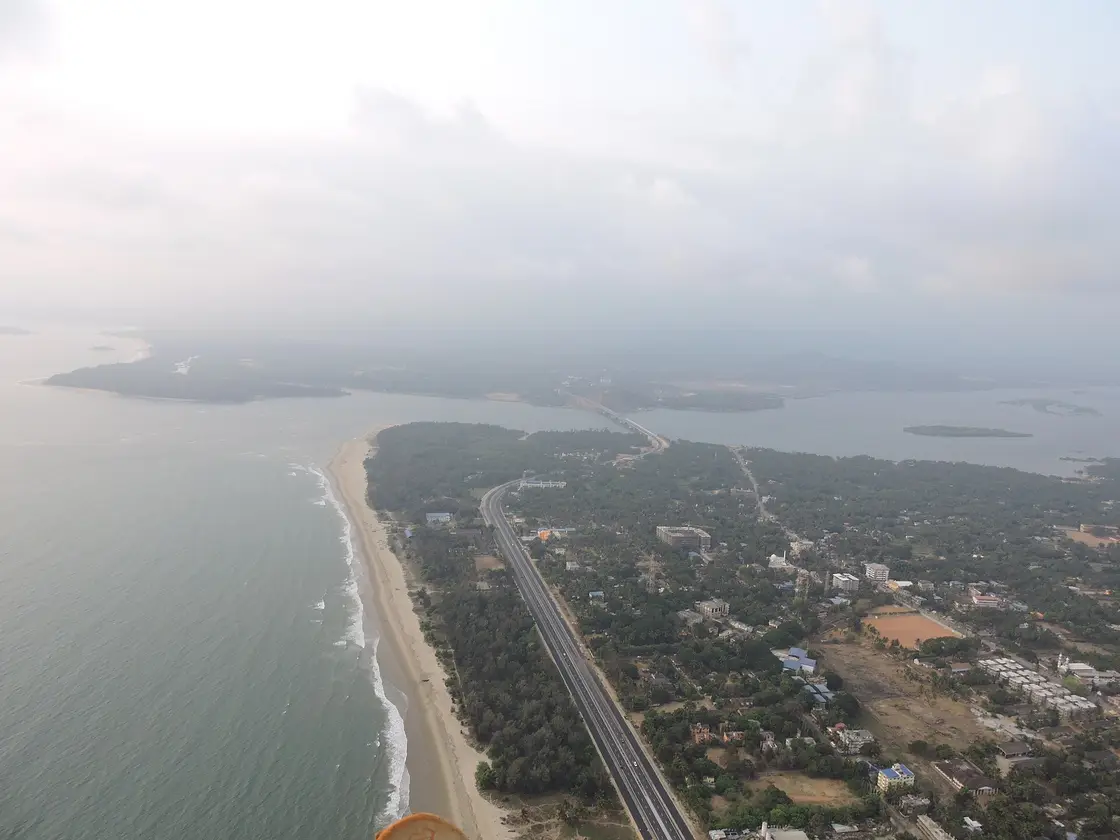
What visitors come for is the sixty-odd kilometres of coast either side, and the fact that it is emptier than Goa's. The town beach is a long shallow bay under a headland; Devbagh across the river mouth is a casuarina-covered spit run partly as a state resort; Majali, 11 km north, is a calm shallow strand behind rock barriers; and Kurumgad sits about four kilometres offshore with a hilltop Narasimha temple. Rabindranath Tagore spent part of 1882 here and wrote a chapter of his memoirs about it, which is why the town beach carries his name and a bust with his sentence about it carved into the plinth.

What to expect

Highlights

  • Karwar Beach — The long shallow town strand of Karwar under its headland, running south from the mouth of the Kali river — the evening promenade of the district headquarters, with fishing boats drawn up on the sand and the Western Ghats behind.
  • Sadashivgad Fort — A Sonda-era hill fort of 1715 above the mouth of the Kali river, about 5 km from Karwar, with the Shantadurga temple and a 17th-century dargah on the way up and the Arabian Sea and its islands below.
  • Kurmagad Island — A tortoise-shaped island ~4 km off Karwar with a hilltop Narasimha temple, snorkelling and an annual jatra; reached by boat.
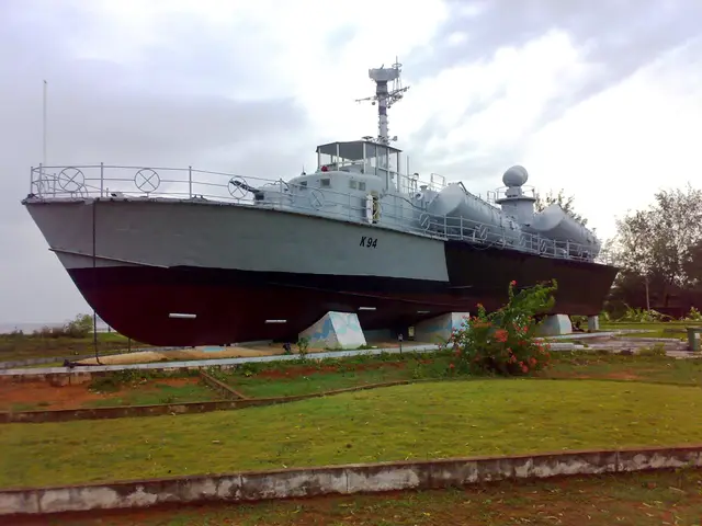
  • Tagore Beach & INS Chapal Museum — Karwar’s main promenade beach, named for Rabindranath Tagore, who stayed here in 1882 and wrote a chapter of his memoirs about it — with the decommissioned missile boat INS Chapal preserved on the sand as a walk-through warship museum and a retired Tu-142 patrol aircraft beside it.
Getting there

How to visit

  • Nearest airport: Karwar has no airport, and the nearest one is in Goa: Dabolim (GOI), which Karnataka Tourism puts at about 90 km — roughly two hours up NH-66 and across the border. Karnataka's own nearest international airport, Mangaluru (IXE), is about 280 km south by the department's figure and 275 km by the district government's, which is five hours of coast road. A civil enclave at the naval air station being built at Alageri near Ankola has been announced as part of Phase 2 of Project Seabird; until it opens, Goa is the airport.
  • Rail gateway: Karwar station (KAWR) is on the Konkan Railway and is the headquarters of that railway's Karwar division, which is more consequence than it sounds: trains from Mumbai, Goa, Mangaluru and Kerala all stop here without a change. It is not in the town. It stands at Shirwad, 6.85 km from the town centre by road and about eight minutes in a taxi — the district government names the station as "Shirwad (Karwar)" for exactly that reason. The station has two platforms. Coming down from Goa the train crosses the Kali on a 1.69 km bridge immediately before it. Madgaon Junction is 68 km north and Mangalore Junction 253 km south; Asnoti and Harwada are smaller stops either side.
  • NH-66, the Mumbai–Kochi coast highway, runs through the town and past the port, and it is how most people arrive. Buses run from Panaji, Hubballi, Belagavi, Mangaluru and Bengaluru, both state and private. Routed on the real road network it is 96 km to Panaji, 165 km to Hubballi, 179 km to Belagavi, 212 km to Udupi, 240 km to Shivamogga, 251 km to Davanagere and 512 km to Bengaluru. ⚠ The district government publishes "86 Kms from Goa", which is the state border rather than Panaji, and 205 km to Haveri; both are consistent with our figures once you know which endpoint is meant.

Distance by road

  • Goa (Panaji)96 km
  • Hubballi165 km
  • Belagavi179 km
  • Udupi212 km
  • Shivamogga240 km
  • Davanagere251 km
  • Bengaluru512 km

Road distances measured on real routed roads to Karwar itself, not to the district headquarters, on 24 August 2026. Driving time is deliberately not published: free-flow routing badly understates a Deccan single-carriageway highway, so allow more than the distance suggests.

Timing

Best time to visit Karwar

November to February is the answer, and it is not close. This is the wettest coast in Karnataka: the monsoon between June and September brings an average of over 400 cm of rain, the sea is dangerous rather than merely rough, and Karnataka Tourism's own advice for the beaches near here is to avoid the season altogether. The port itself is allowed to close from 16 May to 15 September. Winter runs 23–29 °C and is what people come for. March to May is 27–34 °C and humid, peaking near 38 °C, and the sea is warm all year round, which helps less than you would think. October is the gamble month — the rain has usually stopped and the crowds have not started.

Weather in KarwarSeasonal guide

Live forecast loads in your browser.

Today at Karwar
Sunrise6:22 am
Sunset6:45 pm
Golden hour best light5:45 pm–6:45 pm
Blue hour after sunset6:45 pm–7:10 pm
Sun sets toward compass bearingW · 278°
Moon tonight🌖 Waning gibbous · 64%
South-west monsoon. June to September is the south-west monsoon in Karnataka. Expect heavy showers, mostly in bursts rather than all day — carry rain cover, allow extra time for getting around, and note that ferries and open-air sites are the first things affected.

Sun and moon are calculated for this location and shown in IST. Photography windows are the hour around sunrise and sunset; the sunset bearing is degrees clockwise from true north. Moon phase is accurate to about half a day.

Visitor notes

  • Karwar is Konkani-speaking. Kannada is the state language and is understood everywhere, and Hindi and English will get you through, but the language you will hear in the street is Konkani and it sounds much closer to Goa than to Bengaluru.
  • It is a working town rather than a resort. There is no beach strip of bars and no nightlife to speak of, and that is most of the reason people who like it come back.
  • The town has been the district headquarters since 1857 and has the buildings to show for it — a Deputy Commissioner's office, courts, a grid of colonial streets — but it is not a monument town, and nothing here is arranged for visitors.
  • Karavali Utsav, the district's own cultural festival, is held over three or four days at the town beach and fills it with stalls and stages. If you want the beach quiet, ask when it falls before you book.
The story

The story of Karwar

A Konkani port at the mouth of the Kali, built as a British district headquarters in 1857 on a harbour Arab traders had been calling the bay of safety for centuries — and the beach a Bengali poet spent four months looking at and never stopped writing about.

Karwar begins with a harbour rather than a town. The bay is sheltered by hills on the land side and by a string of islands on the sea side, the four-fathom line lies close in, and the tide moves only a metre and a half to two and a half metres. Arab traders called it Bait-e-kol, the bay of safety, and the name survives as Baithkol, which is what the port is still called. Pepper, cardamom and muslin went out of here long before anyone thought of building a town beside it.

The traders came in that order. The Portuguese knew the place as Cintacora, and also as Chitrakul and Sindpur, and in 1510 they captured and burned the fort at the river mouth — calling it Forte de Piro after the dargah of the Sufi saint Shah Karamuddin they found there. In 1638 the English Courteen Association, a rival to the East India Company, opened a factory at Kadwad village six kilometres east, buying muslin, pepper, cardamom, cassia and the coarse blue cotton the trade called dungari. The Association merged into the Company in 1649 and Karwar became a Company town. The Company built fighting ships in this harbour: the Britannia of 1715, eighteen guns, was built here to defend Bombay against the Maratha admiral Kanhoji Angre.

There was still no town. What existed was a creek, a factory, and a scatter of hamlets — Kodibag, Baad, Kathinkon, Sunkeri, Shirwad, Binaga, Habbuwada, Kajubag. The district headquarters of Canara was at Honnavar. Then came 1857, and after the Rebellion the British split Canara in two: South Canara went to the Madras Presidency with its headquarters at Mangaluru, and North Canara went to Bombay with its headquarters at a town that did not yet exist. Karwar was built to be it — laid out deliberately, like Panaji or Dharwad, which is why a place this size has a grid, a wharf, a sea wall and a Deputy Commissioner's office.

The Bombay connection is the thing that made Karwar what it is culturally. For nearly a century the town looked north — Konkani-speaking families with marriages in Bombay, Marathi-medium schools, Marathi films released here, drama troupes from Bombay and Poona touring every year. When the states were redrawn on language in 1956 there was no Konkani state to go to, because Goa was still Portuguese, and Karwar went into Mysore State. The Konkani conferences held in this town through the 1950s and 60s are part of how Konkani came to be recognised as a language in its own right rather than a dialect of Marathi, and it was the Konkani-speaking leadership here, led by P. S. Kamat, that argued before the Mahajan Commission that Karwar belonged in Karnataka. Maharashtra and Goa have both said otherwise since.

The modern town turns on the Navy. INS Kadamba, commissioned on 31 May 2005 and still being built out under the codename Project Seabird, is the third largest naval base in India and the home port of the carrier INS Vikramaditya; the armament depot INS Vajrakosh followed on 9 September 2015. The base took in two beaches and the island of Anjediva. Karnataka Tourism calls Karwar the cradle of Indian naval tradition, and between the wartime training establishment, the Company's shipyard and the base, the phrase is more accurate than most tourism copy.

Legend & myth

The oldest claim made for this coast is in the Sahyadrikhanda of the Skanda Purana, which places the city of Govapuri seven yojanas north of Gokarna and calls it papanashini, the destroyer of sins. Karwar sits inside that stretch, and the reference is the reason the town is sometimes described as part of an ancient Konkan sacred geography rather than as a nineteenth-century British creation. Both are true; they are just seven centuries apart.

Kurumgad, the island four kilometres offshore, is shaped like a tortoise, and the name says so — kurma is the tortoise, the second avatar of Vishnu. The temple on top of the hill is to Narasimha, the fourth. The island's jatra draws boats out from the mainland once a year, which is the one day it is genuinely busy.

More about Karwar

History

1510 — the Portuguese capture and burn the fort at the river mouth, known to them as Cintacora and renamed Forte de Piro after the dargah of Shah Karamuddin.

1638 — the English Courteen Association opens a factory at Kadwad, six kilometres east of the present town, trading muslin, pepper, cardamom, cassia and coarse blue cotton.

1649 — the Courteen Association merges into the East India Company and Karwar becomes a Company town.

21 February 1665 — Shivaji, having marched up from Bednore by way of Gokarna and seized Ankola, crosses the Kali and takes Sadashivgad.

1715 — Basavlingraj of Sonda names the fort at the river mouth Sadashivgad after his father, building it partly from the stones of the old Karwar fort. The Company launches the 18-gun Britannia from this harbour in the same year.

1803 — after the war with Veer Henja Naik the port activity shifts from Kadwad to Baithkol, and the old port is left behind.

1857 — after the Rebellion the British divide Canara, and build Karwar as the new headquarters of North Canara under the Bombay Presidency.

1882 — Rabindranath Tagore, aged twenty-two, comes to stay with his brother Satyendranath, the district judge here, and later devotes a chapter of his memoirs to the town.

1862–1947 — as a Bombay Presidency district headquarters the town gets its roads, its wharf and wharf road, its sea wall, a warehouse, staff housing, a post office, a kutcheri and a Christian burial ground.

1956 — the linguistic reorganisation puts Konkani-speaking Karwar into Mysore State; the Konkani conferences of the following years are held partly in this town.

31 May 2005 — INS Kadamba is commissioned at Binaga under Project Seabird.

9 September 2015 — INS Vajrakosh, the armament and missile depot, is commissioned at Karwar.

Why visit

Because it is the coast Goa used to be, forty minutes further south and without the price. A long shallow bay, a headland, islands offshore, and an evening promenade that belongs to the town rather than to visitors.

Because of the one museum: a decommissioned missile boat sitting on the sand that you can walk through, with a retired maritime patrol aircraft parked beside it.

Because it is a Konkani town in a Kannada state, and the food follows the language — a Goan-Konkan fish curry of coconut and cashew rather than anything you will eat in Bengaluru.

Because the district behind it is the best of coastal Karnataka — Gokarna, Yana, Mirjan, the falls at Magod and Sathodi, the Kali running back up into the Ghats — and Karwar is the practical base for all of it.
Before you go

Karwar — at a glance

HoursThe town does not close and the beaches have no gate. The warship museum keeps daytime hours and is not open every day of the week; we have not found an official timetable for it, so ring ahead or ask at your hotel rather than planning a day around it. Boats to Kurumgad and Devbagh run in daylight and stop early when the sea gets up, which in practice means the monsoon months and any rough spell either side of them.

Entry: Nothing you need to be in Karwar is ticketed. The town beach, the seafront, the Rock Garden and the fort hill at Sadashivgad are all free to walk into. Three things do cost money. The warship museum on the town beach — the decommissioned missile boat INS Chapal, which you go inside — charges a small entry fee at the gate; no official published figure could be verified for it, so treat any number you read online as unconfirmed and expect to pay in cash. The boat out to Kurumgad island is a private hire from the beach or from Devbagh and is negotiated, not tariffed. Water sports on the town beach — parasailing, banana boats, jet skis — are per ride, run by private operators, and priced in the season.

Parking: Free and easy by the standards of anywhere else on this coast. There is open parking along the seafront road by the town beach and beside the warship museum, and space at the foot of the Sadashivgad hill. Nothing here is metered. The exception is the fish market and the harbour road at Baithkol in the morning, which is a working port, not a car park, and where a parked car will be in somebody's way.

Getting here

How to reach Karwar

Getting around

Getting around Karwar

The town is small and mostly flat, and the seafront, the market and the warship museum are within a walk of each other. Autos are the everyday transport and are metered in principle and negotiated in practice; agree the fare first. For anything beyond the town — Devbagh, Majali, Sadashivgad, the station — take an auto or a taxi, or use the state and private services that run along NH-66 in both directions and will drop you on the highway near most of it.

  • 🚕︎ Online taxis Do not count on an app. Karwar is small and app-cab supply here is thin and unreliable; the ordinary way to get a car is to ask your hotel or take a taxi from the stand. Goa-registered cabs come down for drop-offs and are usually unwilling to take a local fare back.
Getting back

Work out your return before you settle into the day. Services in Karnataka thin out sharply in the evening, and Karwar is easier to reach than to leave once the last long-distance bus has gone. We do not publish departure times: there is no official live feed we are permitted to republish, and a wrong time here would strand you. Check the operator directly on the day.

Ask at the bus stand for the time of the last service back, not the next one. If you miss it, an auto or a taxi is the fallback — agree the fare before you get in.

Do

Things to do in Karwar

  • Walk the town beach end to end in the last hour of light. It is a long shallow bay under a headland, and the whole town comes out onto it in the evening — this is the thing Karwar is actually for, and it is free.
  • Go inside INS Chapal. The missile boat sits on a concrete plinth on the beach with a retired Tupolev Tu-142 maritime patrol aircraft beside it, and you walk through the boat itself, mannequins and replica missiles and all. It is a small museum and a genuinely odd one, and there is nothing else like it on this coast.
  • Find the Tagore bust at the beach park and read the plinth. The sentence carved on it is his own, from the memoir he wrote about this beach, and it is worth the two minutes it takes.
  • Cross the Kali bridge to Sadashivgad and climb the hill. The fort of 1715 is ruinous, but the point of the walk is the view from the top — the river mouth, the sea, and the islands strung out across it. The Shantadurga temple and a seventeenth-century dargah are on the way up.
  • Take a boat to Kurumgad. The tortoise-shaped island is about four kilometres offshore, with a Narasimha temple on top of the hill and an annual jatra. Snorkelling trips run out to it and to the smaller islands around it in the clear months.
  • Walk the Rock Garden on the seafront. Its sculptures are of the district's own communities — Halakki, Siddi, Gauli, Gond, Mukri, Kurumbi — and a Yakshagana troupe, and one of them is of Sukri Bommagowda, the Halakki singer who was given a Padma Shri.
  • Eat the fish curry. Karwar cooking is Konkan and Goan more than it is Kannadiga: coconut and cashew in the gravy, ginger and turmeric, and garlic only sometimes. Mackerel, sardine, seer, prawns, clams and crab all come off boats you can watch land at Baithkol.
Plan

Good to know

  • Come between November and February. This is not a preference, it is the difference between a beach and four metres of rain.
  • The station is not in the town. Karwar station is at Shirwad, about 7 km out — factor an auto into every arrival and departure.
  • Carry cash. The museum, the boats, the water sports and the autos all work in cash, and the town is small enough that card acceptance is patchy away from the hotels.
  • If you are coming from Goa, the train from Madgaon is faster, cheaper and prettier than the road, and it crosses the Kali on a 1.69 km bridge right before the station.
  • Ask at the hotel before setting out for the warship museum. Its opening days are not reliably published anywhere.
  • Devbagh is across the river mouth, and the short way there is a boat rather than the highway bridge. Ask which one your booking means before you set off with a suitcase.
Facilities

On site

  • Karwar station (KAWR) at Shirwad, 6.85 km from the centre — two platforms, on the Konkan Railway, and the headquarters of that railway's Karwar division, so long-distance trains from Mumbai, Goa, Mangaluru and Kerala all call here.
  • The bus stand in town, with state and private services along NH-66 to Panaji, Hubballi, Belagavi, Mangaluru and Bengaluru.
  • A government district hospital and a government medical college — Karwar is the district headquarters, so this is the best medical care between Goa and Mangaluru.
  • Banks and ATMs through the town centre, and fuel on the highway in both directions.
  • The fish market and jetty at Baithkol, which is where the catch actually lands, and the town's real morning attraction if you are up early.
Stay safe

Safety

  • The sea is the risk here, not the town. The bay is shallow and generally calm in the dry months, which is exactly why people misjudge it; swim where other people are swimming and not off the rocks or near the river mouth, where the Kali's outflow makes the water move faster than it looks.
  • Between June and September the sea is genuinely dangerous, the rainfall is measured in metres rather than millimetres, and the port itself is permitted to shut. Karnataka Tourism advises against the beaches in those months and it is right.
  • Boat trips to Kurumgad and the islands are private hires. Ask for life jackets and refuse the trip if the sea is up — the boats are small and there is nothing between here and the open Arabian Sea.
  • This is a defence town. Do not photograph the naval base, its jetties or its gates, and do not try to reach Anjediva island, which is inside the base.
Getting around KarwarPartly wheelchair accessible
From the entrance
Karwar town is flat and at sea level, and the parts a visitor uses are the easiest going of any town in this district. The seafront road runs level along the bay with made footways for most of its length, and a car can be brought to the beach park, the warship museum and the Rock Garden. Beyond that it gets harder quickly. The beach itself is soft dry sand above the tideline, which no wheelchair will cross without help. The fort hill at Sadashivgad, across the river, is a climb on an unmade path with loose stone and no handrail, and there is no step-free way to the top. Kurumgad and Devbagh are reached by small boat from an open beach or a jetty, which means a step down into a moving hull.
Step-free access
The seafront, the beach park and the ground around the warship museum are level and reachable by car; the boat inside the museum is entered by a ship's ladder and is not accessible. The sand, the fort hill and the island boats are not. Nothing here has been built to a published accessibility standard and there are no accessible toilets we can point to.
Prams
yes
  • Soft sand above the tideline on the town beach — firm walking only on the wet strip, and only at low tide.
  • Small open boats to Kurumgad and Devbagh: a step down into a moving hull from a beach or a jetty, with no ramp and no fixed schedule.
  • The climb to the fort at Sadashivgad is an unmade path on a hillside, loose underfoot, with no handrail and no lighting.
  • The monsoon changes all of this. Between June and September the sea is dangerous, the rainfall is measured in metres and the boats do not run.

Checked 26 August 2026 against source 1source 2source 3source 4. Conditions change and surfaces vary with weather — if step-free access is essential, confirm with the site before you travel.

If you need help at Karwar
112All emergencies (police · fire · medical)The single number to call in any emergency (ERSS).

Emergency numbers are verified against official government and state tourism sources. 112 works anywhere in India.

Nearby bases

Where to go from Karwar

Mahabaleshwara Temple, Gokarna, GokarnaFeatured: Mahabaleshwara Temple, Gokarna
Town / base

Gokarna

The Kanara pilgrimage town — the Mahabaleshwara Atmalinga temple and the string of beaches from the town beach south past Kudle and Om to the secluded Half Moon and Paradise coves, with Mirjan Fort on the Aghanashini nearby.

Mahabaleshwara Temple, GokarnaGokarna BeachOm BeachKudle Beach
Open Gokarna guide →
Murudeshwara Temple, MurudeshwaraFeatured: Murudeshwara Temple
Town / base

Murudeshwara

The southern Kanara coast — the headland temple of Murudeshwara with its giant Shiva statue, and the Ganapathi temple at Idagunji near Honnavar.

Murudeshwara TempleIdagunji TempleNetrani Island
Open Murudeshwara guide →
Sirsi Marikamba Temple, SirsiFeatured: Sirsi Marikamba Temple
Town / base

Sirsi

The inland Sahyadri hub — the great Marikamba temple at Sirsi, the Yana rock spires, and the Unchalli, Sathodi and Magod waterfalls in the surrounding forests.

Sirsi Marikamba TempleYanaUnchalli FallsSathodi Falls
Open Sirsi guide →
Dandeli Wildlife Sanctuary, DandeliFeatured: Dandeli Wildlife Sanctuary
Town / base

Dandeli

The northern forest belt on the Kali river — the Dandeli wildlife sanctuary and Kali Tiger Reserve, famous for white-water rafting and birding.

Dandeli Wildlife SanctuaryUlavi Channabasaveshwara TempleSupa DamSyntheri Rocks
Open Dandeli guide →
Banavasi Madhukeshwara Temple, BanavasiFeatured: Banavasi Madhukeshwara Temple
Town / base

Banavasi

The ancient Kadamba capital on the Varada river, the oldest town in Karnataka — the 9th-century Madhukeshwara Shiva temple with its stone Nandi and lathe-turned pillars.

Banavasi Madhukeshwara Temple
Open Banavasi guide →
Waterfalls base
Town / base

Siddapur

The Siddapur taluk in the evergreen Sahyadri — the Shivaganga fall on the Sonda river and the trek to the multi-tier Benne Hole Falls.

Shivaganga FallsBenne Hole Falls
Open Siddapur guide →
Apsarakonda Falls, HonnavarFeatured: Apsarakonda Falls
Town / base

Honnavar

The Honnavar coast at the mouth of the Sharavathi — the tiered Apsarakonda falls and beach and the boat trip to the ruined sea-fort of Basavaraja Durga Island.

Apsarakonda FallsBasavaraja Durga Island
Open Honnavar guide →
Vibhooti Falls, AnkolaFeatured: Vibhooti Falls
Town / base

Ankola

The Ankola taluk between the Ghats and the sea — the limestone Vibhooti falls near Yana and the Ramsar mangrove backwaters of the Aghanashini estuary.

Vibhooti FallsAghanashini Estuary
Open Ankola guide →
Ghats & waterfalls base
Town / base

Yellapur

The forested Yellapur taluk on the Bedti and Kali rivers — the Jenukallu Gudda sunset viewpoint and the remote Lalguli falls in elephant country.

Jenukallu GuddaLalguli Falls
Open Yellapur guide →
Doeguling Tibetan Settlement, MundgodFeatured: Doeguling Tibetan Settlement
Town / base

Mundgod

The Mundgod belt on the eastern edge of the district — Doeguling, India’s second-largest Tibetan settlement, with the great Drepung Loseling and Ganden monasteries.

Doeguling Tibetan Settlement
Open Mundgod guide →
In the district

Where Karwar sits in Uttara Kannada district

District HQKarwar
LandscapeThe Kanara coast where the Western Ghats meet the Arabian Sea, cut by the Kali, Aghanashini, Bedti and Sharavathi rivers; heavily forested

Uttara Kannada district is known for: The Kanara coast — the temple town and beaches of Gokarna, the giant Shiva of Murudeshwara, the Yana rock spires, the Sahyadri waterfalls around Sirsi and Yellapur, and the Dandeli forests and Kali-river rafting.

Mahabaleshwara Temple, GokarnaMurudeshwara TempleYana
Stay · eat · do · rent · see · shop

Places in Karwar

Every verified place in Karwar — filter by what you’re after.

E
Emerald Bay, Karwar, Sterling Holidays
Place to stay
Top pick
Hotel
Emerald Bay, Karwar, Sterling Holidays
3-star

A three-star resort operated by Sterling Holidays on the coast about 5 km south of the town centre, and the largest branded hotel in Karwar. OpenStreetMap's surveyors visited it on the ground and recorded wi-fi, wheelchair access and the three-star grade. It is a package resort rather than a town hotel: expect to be driven in and out for everything in Karwar itself.

Directions Commission-freeView details
P
Prafulla Homestay
Place to stay
Top pick
Homestay
Prafulla Homestay

Homestay on Ocean Deck Road at Sadashivgad, north of the river and roughly 8 km round from the town centre, near the estuary rather than the town beach. OpenStreetMap records its address as Ocean Deck Rd, Sadashivgad, Karwar 581352 and a mobile number for it; there is no website, so confirm rooms and rates on the phone.

Directions Commission-freeView details
E
Estuary View Resort
Place to stay
Top pick
Homestay
Estuary View Resort

Guest house on the Sadashivgad side of the Kali, named for the view it is built to face — the river mouth where the Kali meets the Arabian Sea, with the islands beyond it. About 6 km round by road from the town centre, which puts it away from the town beach and beside the estuary instead. It publishes no website or tariff we could verify; ring ahead in season.

Directions Commission-freeView details
S
Shree Mahamaya Temple
Sight
Top pick
Temple
Shree Mahamaya Temple

A Mahamaya temple about 7 km round from the town centre, on the north side of the river. Mahamaya is the goddess in her form as the great illusion, and temples to her are a Konkan-coast pattern rather than an inland Karnataka one. A neighbourhood temple in use, not a monument, and it shares its name with a hotel on the Link Road nearby.

DirectionsView details
S
Shejjeshwar Temple
Sight
Top pick
Temple
Shejjeshwar Temple

A Shiva temple roughly 4.5 km round from the town centre, recorded in OpenStreetMap under its Kannada name as well as its English one. It is a working local temple with no published history, no timings and no ticket — the ordinary religious furniture of a Konkan town rather than a visitor attraction, and worth a look only if you are passing.

DirectionsView details
S
Shree Mahaladeva Mahasati Devi Devastana
Sight
Temple
Shree Mahaladeva Mahasati Devi Devastana

A temple to Mahaladeva and the Mahasati goddess, out at about 9 km round from the town centre and the furthest of the town's recorded shrines. Mahalasa and the sati goddesses belong to the same Goan-Konkan religious world as the Shantadurga temple on the fort hill. Nothing about its history or its hours is published anywhere we could check.

DirectionsView details
S
Shree Annapurneshwari Hotel
Where to eat
Restaurant
Shree Annapurneshwari Hotel

A small eating house near the Kali River Garden at Kodibag, at the north end of the town about forty minutes' walk from the centre. "Hotel" here means what it means all over coastal Karnataka — a plate-meals restaurant, not a place to sleep. Named for Annapurneshwari, the goddess of food, which on this coast usually signals a vegetarian kitchen; it publishes nothing, so check before you count on it.

Directions Commission-freeView details
H
Hotel Happinezz
Where to eat
Restaurant
Hotel Happinezz

A roadside restaurant on the Panvel–Kochi–Kanyakumari highway — NH-66 — at Kodibag, on the northern edge of town about half an hour's walk from the centre. A highway kitchen rather than a destination, and a straightforward stop if you are driving in from Goa. Nothing about its hours or menu is published.

Directions Commission-freeView details
S
Shagun Hotel
Where to eat
Restaurant
Shagun Hotel

A restaurant at Kodibag, beside the Indian Bank and near the Radha Krishna temple, and one of the closest eating houses to the town centre — about thirteen minutes on foot. OpenStreetMap carries the address; there is no website, no published menu and no hours we can vouch for.

Directions Commission-freeView details
K
Karwar Chicken
Where to eat
Restaurant
Karwar Chicken

A meat restaurant on KEB Road opposite the Sagar Complex, a quarter of an hour's walk from the town centre, and one of the handful of non-vegetarian kitchens in the middle of town. Karwar's cooking is Konkan and Goan more than Kannadiga — coconut, cashew and ginger in the gravy — and the everyday version of it is eaten in rooms like this rather than in hotels.

Directions Commission-freeView details
B
Bangarappa Hotel
Where to eat
Restaurant
Bangarappa Hotel

An eating house on INP Road at Baithkol, by the fishing harbour about fifty minutes' walk south of the town centre. Baithkol is where the catch actually lands — mackerel, sardine, seer, prawns, clams and crab — and the kitchens around the harbour road are the reason to be down there at all. Nothing about it is published; go and look.

Directions Commission-freeView details
V
Vihar Hotel
Where to eat
Restaurant
Vihar Hotel

A restaurant at the Mahalasa cross on the Karwar road, listed in OpenStreetMap with a Binaga and Ankola address — that is the stretch south of Karwar towards the naval base, not the town centre, and it is about 3.5 km out. Useful if you are already on that road; not somewhere to walk to from the beach.

Directions Commission-freeView details
G
Geeta Chicken Center a
Where to eat
Restaurant
Geeta Chicken Center a

A meat kitchen at Arga, on the coast road well south of the town — the same Arga whose beach went into naval property when the base at Binaga was built. About 9 km round from the town centre, so a drive rather than a walk. The trailing "a" in the name is how it is recorded in OpenStreetMap and is almost certainly a typing slip in the survey, not part of the name.

Directions Commission-freeView details
H
Hotel Mahamaya
Place to stay
Hotel
Hotel Mahamaya

Hotel on Link Road at Sadashivgad, on the Majali side of the river bridge and about 5 km from the town centre — a useful position if you are heading for Majali beach or driving on to Goa rather than staying on the town seafront. No official website or published tariff could be verified for it.

Directions Commission-freeView details
S
St. Joseph's Church
Sight
Church
St. Joseph's Church

A Catholic parish church in the town, half an hour's walk from the centre, and recorded in OpenStreetMap under its Portuguese and Spanish names as well as its English one — Igreja São José. That is not decoration: Christianity came to this coast with the Portuguese in Goa in the sixteenth and seventeenth centuries, and Karwar's Catholic families descend from those congregations. A working parish; visit outside Mass.

DirectionsView details
S
Shantadurga Temple
Sight
Temple
Shantadurga Temple

A Shantadurga temple on the Sadashivgad hill, about 6 km round from the town centre and on the way up to the fort. Shantadurga is one of the great Goan goddesses — the peacemaker form of Parvati — and her presence here is a plain marker of how far the Konkan cultural world reaches south of the state border. A living temple: shoes off, and it is used, not exhibited.

DirectionsView details
S
Shan Shamsuddin Kharobat Dargah
Sight
Mosque
Shan Shamsuddin Kharobat Dargah

The tomb of Sayed Shamsuddin, called Shah Karamuddin Auliya, on the Sadashivgad side of the river — and the single oldest thing in the Karwar story that you can still stand in front of. When the Portuguese captured and burned the fort at this river mouth in 1510, they named the place Forte de Piro after the dargah of a Sufi saint they found there, and this is that saint. Nearly five centuries later it is still a working shrine.

DirectionsView details
I
Inspection Bungalow
Place to stay
Guest house
Inspection Bungalow

The government inspection bungalow in the town centre, eleven minutes' walk from the seafront — the old Public Works rest house of the kind every district headquarters in India has, built for touring officials and let to the public only when it is free and only through the department. Not a hotel: there is no booking site, no tariff card and no reception in the usual sense. Worth knowing about, not worth planning around.

Directions Commission-freeView details
C
Community Park
Nature
Park
Community Park

A public park about fifteen minutes' walk from the town centre — a neighbourhood green rather than a destination, with the ordinary benches, paths and evening walkers of a small district town. Free and open; nothing is published about its hours.

DirectionsView details
S
Swami Vivekananda Statue
Sight
Attraction
Swami Vivekananda Statue

A statue of Swami Vivekananda about 3.5 km round from the town centre, recorded in OpenStreetMap as an attraction under its Kannada name. It is a civic monument of the kind found in most Indian district towns rather than a historic one — a five-minute stop if you are already going past, and no more than that.

DirectionsView details
C
Children Park
Nature
Park
Children Park

The closest of the town's parks to the centre, eleven minutes on foot — a children's playground rather than a garden, and the obvious release valve if you are travelling with small children and the beach is too hot in the middle of the day. Free, unticketed, and no published hours.

DirectionsView details
K
Kali River Garden
Nature
Park
Kali River Garden

A riverside public garden at Kodibag, at the north end of the town where the Kali comes down to the sea, about 3.5 km round from the centre. It is named in the district's own list of places of interest in Karwar. What it is for is an evening hour by the water with the bridge and the estuary in front of you — free, unticketed, and busiest at sunset.

DirectionsView details

Book with the place itself. India’s cyber-crime coordination centre warned in April 2025 that convincing copies of hotel and pilgrimage booking sites are being pushed through sponsored search and social ads, taking payment for rooms the property never hears about. Every listing here links to the business’s own contact details and its own Google or Bing profile — we take no commission and sit in nobody’s payment path. If a booking page reached you through an ad, check the address bar against the property’s own site before you pay. Fraud can be reported on cybercrime.gov.in or on 1930.

Ranked

The best of Karwar, ranked

Nearest to the centre of Karwar, on foot

Ordered by a real routed walk from the town centre — a different question, and the one that decides what you can do before lunch. Straight-line distance understates a real walk by about half again, so these are walking-network figures, not lines on a map.

Everything around Karwar, by distance

Every place we hold for Karwar, ordered by a real routed drive from the town centre. Times are free-flow and a real road rarely is, so read them as the floor rather than the estimate — anything that routed over ninety minutes is left out rather than published as a number we do not trust.

For hotels, homestays and local businesses

Get listed in Karwar for free

Roampedia is commission-free. Travellers discover your business, book directly and contact you through official details. Basic listings are free, while Gold and Platinum package upgrades can be requested from the owner dashboard after approval.

List your business — free
Read before you go

Karwar guides, stories & itineraries

Stories & history of Karwar

Written about Karwar itself — its history, its legends and the arguments about them.

Nearby in Uttara Kannada

Wider reading from Uttara Kannada. The stories about Karwar itself are above.

Planning a trip to Karwar

The practical half — what is actually here, in what order to see it, and how to arrive.

Karnataka-wide guides & itineraries

Route-level itineraries and practical guides for the rest of the state.

See all 13 Uttara Kannada guides & stories →

Map

Where things are in Karwar

FAQ

Karwar travel FAQs

Is Karwar worth stopping for, or should I go straight to Gokarna?

Both, in that order. Karwar is the district headquarters and a working port town — a long town beach, a warship museum, a fort hill across the river and islands offshore — and it takes a day. Gokarna, an hour and a half south, is a temple town with a different set of beaches and a very different crowd. Coming down from Goa, Karwar is the first place in Karnataka you reach, and skipping it to save ninety minutes is a poor trade.

What is the nearest airport to Karwar?

Dabolim in Goa (GOI), about 90 km by Karnataka Tourism’s figure — roughly two hours by road. Karnataka’s own nearest airport, Mangaluru (IXE), is about 280 km south, which is five hours. A civil enclave at the naval air station near Ankola has been announced under Phase 2 of Project Seabird, but until it opens the answer is Goa.

Where is Karwar railway station?

At Shirwad, 6.85 km from the town centre by road and about eight minutes in a taxi — which is why the district government lists it as “Shirwad (Karwar)”. It is on the Konkan Railway and is the headquarters of that railway’s Karwar division, so trains from Mumbai, Goa, Mangaluru and Kerala all call here. Madgaon Junction is 68 km north, Mangalore Junction 253 km south.

When should I not go to Karwar?

June to September. This is one of the wettest stretches of the Indian coast — the monsoon here averages over 400 cm — the sea is dangerous rather than merely rough, and the port itself is permitted to close between 16 May and 15 September. November to February is the season; October is a gamble that usually pays.

Can you swim at Karwar?

Yes, in the dry months, and it is one of the calmer bays on this coast — the town beach is shallow and sheltered, and Majali, 11 km north, is calmer still behind natural rock barriers. Two cautions: keep away from the river mouth, where the Kali’s outflow moves the water faster than it looks, and do not go in at all during the monsoon.

What is the INS Chapal museum?

A decommissioned missile boat of the Indian Navy, preserved on a concrete platform on the town beach and opened up as a walk-through warship museum, with mannequins in the crew positions and replica missiles inside. A retired Tupolev Tu-142 maritime patrol aircraft stands beside it. No official opening times or ticket price are reliably published, so ask locally before you plan a day around it.

Is Karwar a Kannada-speaking town?

It is in Karnataka, so Kannada is the official language and is understood everywhere — but the town’s own language is Konkani. Karwar was in the Bombay Presidency until 1956 and its ties were to Bombay and Goa; the Konkani conferences held here in the 1950s and 60s helped establish Konkani as a language in its own right. The name itself is Konkani: Kadwad, kade-wada, the last ward.

Can I visit the naval base?

No, not ordinarily. INS Kadamba is an operational base and takes up a long stretch of the coast south of the town, including Anjediva island and two former public beaches. It opens to the public during Navy Week in December and for organised educational groups. Around the base, the port and the jetties, do not photograph defence installations.

What are the best places to visit in Karwar?

Top places to visit in Karwar include Karwar Beach, Sadashivgad Fort, Kurmagad Island, Tagore Beach & INS Chapal Museum — each has a full guide with how to reach it and what to see nearby on this page.

How do I reach Karwar?

The nearest airport to Karwar is Dabolim, Goa (GOI), ~90 km from Karwar; Hubballi (HBX), ~165 km by road. The rail gateway is Karwar, Gokarna Road, Kumta, Honnavar and Murdeshwar on the Konkan Railway. NH-66 coastal highway and NH-63 to Hubballi (~500 km from Bengaluru, ~90 km from Goa); KSRTC and private buses, autos and taxis.

What is the best time to visit Karwar?

October to February is the coolest, most comfortable season to visit Karwar and the rest of Karnataka. March to May is hot on the plains, and the June–September southwest monsoon brings the main rains, heaviest along the coast and Western Ghats.

Photographs: DeepakBerwal12, CC BY-SA 4.0, via Wikimedia Commons (CC BY-SA 4.0), R. Indu Mathi, CC BY-SA 4.0, via Wikimedia Commons (CC BY-SA 4.0), OmWiki101, CC BY-SA 4.0, via Wikimedia Commons (CC BY-SA 4.0), Ayan Mukherjee, CC BY 3.0, via Wikimedia Commons (CC BY 3.0), Mujib MK from India, CC BY 2.0, via Wikimedia Commons (CC BY 2.0), Agnel3, CC BY-SA 3.0, via Wikimedia Commons (CC BY-SA 3.0), Vssonnet, CC BY-SA 3.0, via Wikimedia Commons (CC BY-SA 3.0), ರವಿಮುಂ, CC BY-SA 4.0, via Wikimedia Commons (CC BY-SA 4.0), Ray Swi-hymn from Sijhih-Taipei, Taiwan, CC BY-SA 2.0, via Wikimedia Commons (CC BY-SA 2.0), Gopal Vijayaraghavan from Bangalore, India, CC BY 2.0, via Wikimedia Commons (CC BY 2.0). Wikimedia Commons.

Image credits