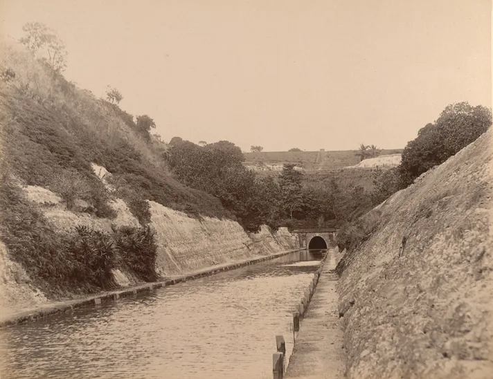
At Kappil, the backwater can look like a quiet accompaniment to the sea. A few kilometres south, the Varkala ridge once made a continuous inland boat journey impossible. Travancore’s response was to cut a passage through the hill.
A short tunnel, then a long one
The 1971 Census town survey records two horse-shoe-shaped Varkala tunnels: one about 282 metres long, opened to traffic on 15 January 1877, and another about 721 metres long, completed and opened in 1880. A 1906 Travancore State Manual records the same sequence. The earlier version of this article gave the short tunnel as 350 metres and assigned the long tunnel the earlier opening. Those details do not match these government records.
The tunnels joined inland waters on either side of the ridge. A British Library photograph of the canal approach survives from the era when the waterway was part of ordinary transport. Looking at it changes the usual beach narrative: this coast was also engineered for movement of people and goods.
The name that caused confusion
This is the Thiruvananthapuram–Shoranur canal story. It is not correct to call the Varkala tunnels part of the present National Waterway 3 route. The Inland Waterways Authority lists National Waterway 3 as the Kottapuram–Kollam West Coast Canal, with separate feeder canals; Kollam lies north of Varkala. A larger coastal-waterway ambition and a currently notified national route are different things.
A new chapter, with a current-status check
An Inland Waterways Authority document from February 2026 describes renovation of the Chilakoor tunnel as part of the Akkulam–Chettuva project. That dated report does not guarantee that a public boat ride runs today, or that both old tunnels are navigable. If the tunnel is the reason for your visit, confirm the operator, boarding point and current service before leaving Varkala.
The more durable reason to care is visible even without a ticket: a pair of relatively small cuts solved a large geographical obstacle. They show that the apparently still waters behind the beach belonged to a route, not merely a view.
A landscape built for movement
The beach view hides the reason the water behind it matters. This is a segment of a coastal inland route, and the Varkala tunnels solved a local obstacle where a hill interrupted that line. A quiet boat view at Kappil and a historic engineering work belong to one map. The Edava–Nadayara name story helps locate the water without reducing it to an isolated lake.
Historic canal accounts tell us what the route was built to do. Current boatability is a separate question, affected by maintenance, water level and access decisions. Check the relevant navigation or tourism notice before treating a reported reopening as a standing promise of a through trip.
At Kappil, look landward as well as out to sea. The still water is not merely scenery behind the beach; it is a line that once connected places beyond the horizon of a single photograph.