Places to Visit in Kakkabe

The Kakkabe–Virajpet uplands — Tadiandamol, Kodagu’s highest peak, the Nalknad royal palace, the Kodava Padi Igguthappa temple and Chelavara Falls.

Tadiandamol, Kakkabe
Practical guide

Plan Kakkabe

Who's going?Tailor Kakkabe to your trip
DistrictKodagu
RoleTrek & Kodava-heartland base
Places to visit4
What to expect

Highlights

  • Tadiandamol — The highest peak in Kodagu at about 1,748 m, near Kakkabe, and one of the most popular treks in Coorg — a half-day climb through shola forest and rolling grassland to a summit with sweeping Western Ghats views; the historic Nalknad Palace lies at its base.
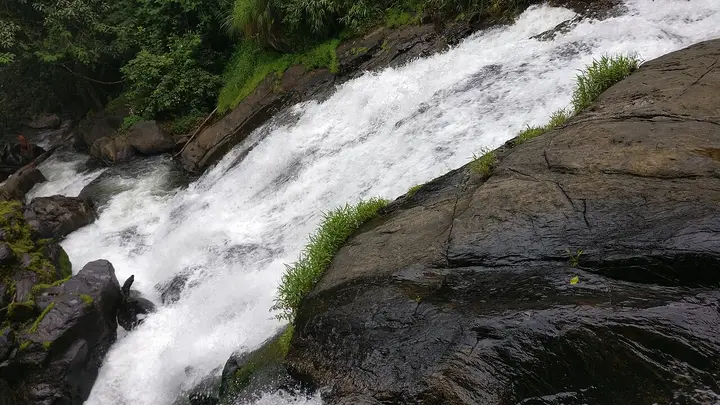
  • Chelavara Falls — A cascade on a tributary of the Kaveri near Cheyyandane, close to Kakkabe, tumbling over a broad rock face; a short walk from the road (the descent to the base is often restricted), it is best just after the monsoon.
  • Padi Igguthappa Temple — The most important temple of the Kodava people, near Kakkabe, dedicated to Igguthappa (a form of Subramanya/Kartikeya); a Kerala-influenced shrine that is the focus of the community’s Kailpodh and other festivals.
  • Nalknad Palace — A 1792 palace of the Kodagu (Haleri) kings tucked among coffee estates at the foot of Tadiandamol near Kakkabe, its wooden halls painted with faded murals; it was the last refuge of the Kodagu royals before the British annexation.
Getting there

How to visit

  • Nearest airport: Mangaluru (IXE), ~135 km; Mysuru (MYQ), ~120 km; Bengaluru (BLR), ~260 km
  • Rail gateway: Mysuru (MYS), ~120 km, or Hassan — Kodagu has no railway of its own
  • KSRTC and private buses via Mysuru, Mangaluru and Hassan; a taxi or own vehicle is best for estate, waterfall and hill routes.

Distance by road

  • Mysuru131 km
  • Hassan133 km
  • Mangaluru159 km
  • Udupi210 km
  • Bengaluru270 km
  • Shivamogga278 km

Road distances measured on real routed roads to Kakkabe itself, not to the district headquarters, on 24 August 2026. Driving time is deliberately not published: free-flow routing badly understates a Deccan single-carriageway highway, so allow more than the distance suggests.

Timing

Best time to visit Kakkabe

Weather in KakkabeSeasonal guide

Live forecast loads in your browser.

Today at Kakkabe
Sunrise6:17 am
Sunset6:38 pm
Golden hour best light5:38 pm–6:38 pm
Blue hour after sunset6:38 pm–7:03 pm
Sun sets toward compass bearingW · 278°
Moon tonight🌖 Waning gibbous · 74%
South-west monsoon. June to September is the south-west monsoon in Karnataka. Expect heavy showers, mostly in bursts rather than all day — carry rain cover, allow extra time for getting around, and note that ferries and open-air sites are the first things affected.

Sun and moon are calculated for this location and shown in IST. Photography windows are the hour around sunrise and sunset; the sunset bearing is degrees clockwise from true north. Moon phase is accurate to about half a day.

Practical things near Kakkabe

Mapped within about 1.2 km of Kakkabe, with real walking routes rather than straight-line distances. Community-mapped data: opening hours are shown only where they are recorded, and this is not a complete list — something unmapped may well be closer. Please confirm on the ground.

In the district

Where Kakkabe sits in Kodagu district

Nearest airportMangaluru (IXE), ~135 km; Mysuru (MYQ), ~120 km; Bengaluru (BLR), ~260 km
Rail gatewayMysuru (MYS), ~120 km, or Hassan — Kodagu has no railway of its own
Bus / road accessKSRTC and private buses via Mysuru, Mangaluru and Hassan; a taxi or own vehicle is best for estate, waterfall and hill routes.
District HQMadikeri
LandscapeWestern Ghats coffee highland, ~1,150 m at Madikeri

Kodagu district is known for: Coorg coffee country — Madikeri hill town, Abbey Falls, the Kaveri source at Talakaveri, Tibetan Bylakuppe and the Dubare elephants.

Madikeri & Abbey FallsNamdroling Golden Temple, BylakuppeTalakaveri — the Kaveri source
Stay · eat · do · rent · see · shop

Places in Kakkabe

Every verified place in Kakkabe — filter by what you’re after.

Verified inventory is being added here.

Verified places are being added. The category filters will fill in as approved stays, restaurants, experiences, sights, shops and nature listings go live.

List your place
For hotels, homestays and local businesses

Get listed in Kakkabe for free

Roampedia is commission-free. Travellers discover your business, book directly and contact you through official details. Basic listings are free, while Gold and Platinum package upgrades can be requested from the owner dashboard after approval.

List your business — free
Map

Where things are in Kakkabe

FAQ

Kakkabe travel FAQs

What are the best places to visit in Kakkabe?

Top places to visit in Kakkabe include Tadiandamol, Chelavara Falls, Padi Igguthappa Temple, Nalknad Palace — each has a full guide with how to reach it and what to see nearby on this page.

How do I reach Kakkabe?

The nearest airport to Kakkabe is Mangaluru (IXE), ~135 km; Mysuru (MYQ), ~120 km; Bengaluru (BLR), ~260 km. The rail gateway is Mysuru (MYS), ~120 km, or Hassan — Kodagu has no railway of its own. KSRTC and private buses via Mysuru, Mangaluru and Hassan; a taxi or own vehicle is best for estate, waterfall and hill routes.

What is the best time to visit Kakkabe?

October to February is the coolest, most comfortable season to visit Kakkabe and the rest of Karnataka. March to May is hot on the plains, and the June–September southwest monsoon brings the main rains, heaviest along the coast and Western Ghats.

Image credits