What to expect
Highlights
- The cliff-set Veerabhadra temple beside the falls.
- The post-monsoon cascade down the rock.
- A short stop on the Kemmanagundi circuit.
Kalhattigiri (Kalhatti) Falls lies at the foot of the Chandra Drona hills near Kemmanagundi, where a hill stream drops down the rock face past a Veerabhadra Swamy temple built into the cliff.
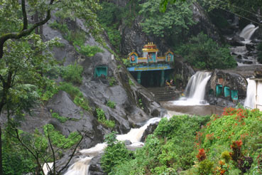
The temple and the falls together make it both a pilgrimage and a scenic stop; the water is a fine cascade after the monsoon and a trickle in the dry season.
A 45-metre cascade that runs across the rock beside Veerabhadreshwara Temple, ten kilometres below Kemmanagundi. Kalhattigiri is both a waterfall stop and a living place of worship, so the wet stone, temple etiquette and seasonal flow matter as much as the view.
Kalhattigiri lies on the road climbing towards Kemmanagundi in the Chandra Drona hills. Unlike a remote forest fall, its identity is inseparable from the Veerabhadreshwara Temple at the foot of the rock: visitors arrive in the same small space to worship, stand near the falling water and continue uphill.
Karnataka Tourism describes the water descending about 45 metres and flowing in front of the Shiva temple. The entrance is marked by two large stone elephants, an image repeated in official descriptions of the site. The temple itself is attributed there to the Vijayanagara period, though no firm construction date is supplied.
This is a monsoon-fed mountain stream, not a controlled water feature. Post-monsoon flow gives the place its drama, while rain also makes the approach and the rock under the cascade slick. A quiet visit in moderate conditions is a different experience from a crowded bathing stop in heavy flow.
The practical geography is simple: Kemmanagundi is the hill base, about 10 km away; Chikkamagaluru is much farther by winding road. Karnataka Tourism gives 53 km from Chikkamagaluru and Birur Junction as the closest railway station at 25 km. Those published figures are more useful than treating the district headquarters as the immediate base.
Local tradition connects the site with the sage Agastya and treats the water beside Veerabhadreshwara as sacred. This is living belief rather than a dated historical event, and it is best understood through the temple practices visitors encounter at the falls.
The Veerabhadreshwara Temple beside the cascade is attributed by Karnataka Tourism to the Vijayanagara period. The official account does not give a precise foundation inscription or construction year, so this guide does not invent one.
Today the fall is promoted as part of the Kemmanagundi circuit. The state tourism department places it 10 km from Kemmanagundi, 53 km from Chikkamagaluru and 25 km from Birur Junction railway station.
Visit for the unusual overlap of cascade and active shrine: the water, stone elephants and temple occupy one compact setting rather than separate stops.
Use it as a short part of a Kemmanagundi day, not as a stand-alone expedition. Go in daylight, wear footwear with grip, remove it where worship requires and keep away from forceful water after heavy rain.
Road km to Chikkamagaluru; ghat roads and traffic vary — allow extra.
July to December for full flow; combine with Kemmanagundi.
Live forecast loads in your browser.
Sun and moon are calculated for this location and shown in IST. Photography windows are the hour around sunrise and sunset; the sunset bearing is degrees clockwise from true north. Moon phase is accurate to about half a day.
Verified hotels, homestays, restaurants, experiences, sights, shops and rentals around Kalhattigiri Falls — commission-free, with direct contact. Filter by what you need.
The Karnataka government's own accommodation on the hill, run by Jungle Lodges and Resorts, which took over the guest houses and the restaurant here on 1 March 2021 by government order. Rooms are spread across named blocks and cottages — Virupaksha, Budangiri, Narayana Kuteera and Kallathi — and packages include meals, a guided Z Point trek and the jeep trip down to Hebbe Falls. Book direct through the numbers below rather than an agent; this is the only sizeable place to sleep at the top of Kemmanagundi.
The state Horticulture Department's guest house, standing inside the Krishnarajendra botanical park and still called Raj Bhavan after the Mysore king whose summer retreat this was. It is the landmark everything on the hill is measured from — the Z Point path and the Hebbe Falls jeeps both start here — and it takes visitors in a plain, government-run way rather than as a resort. Rooms go through the Horticulture Department, not through a booking site, so enquire ahead; turning up unannounced in season is optimistic.
A homestay of independent cottages on Glendale Farms at Ballavara, on the Kemmanagundi road below the hill station, taking guests since 2010. It sits in its own grounds with a swimming pool, a campfire and walks out through the plantation, and it books direct on its own site and phone rather than through a platform. Being partway up the hill it works as a base for both Kemmanagundi and the Baba Budan range, and it is a different proposition from the government rooms at the top.
A second Horticulture Department guest house, this one down at Kallathi village beside the Kallathigiri falls and the rock-cut Veerabhadra temple, about 10 km from the Kemmanagundi gardens. It is basic government accommodation rather than a hotel and it exists mainly because the falls draw people, but it is a genuine option if the rooms at the top of the hill are full. Enquire through the Horticulture Department; there is no booking site.
Book with the place itself. India’s cyber-crime coordination centre warned in April 2025 that convincing copies of hotel and pilgrimage booking sites are being pushed through sponsored search and social ads, taking payment for rooms the property never hears about. Every listing here links to the business’s own contact details and its own Google or Bing profile — we take no commission and sit in nobody’s payment path. If a booking page reached you through an ad, check the address bar against the property’s own site before you pay. Fraud can be reported on cybercrime.gov.in or on 1930.
Find food, accommodation and activities across Kemmanagundi. Browse the guides for places to eat, stay and explore along your route.
Walking routes start at Kalhattigiri Falls. Check the route and access before setting out, especially where a road, gate or waterway separates the stops.
One more place around Kemmanagundi worth a day of its own.

35.7 km · 42 min drive
A Hoysala temple of 1196 CE to Amrutesvara (Shiva) at Amruthapura in Tarikere taluk, on a star-shaped plan with a fine tower, a long inscribed hall and detailed friezes — a quieter cousin of Belur and Halebidu.
Roampedia is commission-free — own or know a stay, eatery, guide or shop near Kalhattigiri Falls? List it and it appears here once verified.
Add a nearby businessEntry: No verified visitor fee
The temple, cascade and immediate viewpoints are explored on foot, over wet and uneven ground. A retained car or pre-arranged local vehicle is the dependable way to reach other Kemmanagundi sights; do not rely on finding a return ride at the falls.
Online taxis: Do not build the trip around an instant app booking. Driver supply on the Kemmanagundi hill road is not verified; keep the vehicle that brought you, agree waiting time in advance and save the driver number before signal becomes weak.
If you are travelling by bus or ferry, check the return service with the operator before setting out. Leave time to reach the stop or jetty after your visit.
Ask at the jetty or stand for the time of the last service back, not the next one. If you miss it, an auto or app cab is the fallback — agree the fare before you get in.
Checked 4 September 2026 against source 1source 2. Conditions change and surfaces vary with weather — if step-free access is essential, confirm with the site before you travel.
Emergency numbers are verified against official government and state tourism sources. 112 works anywhere in India.
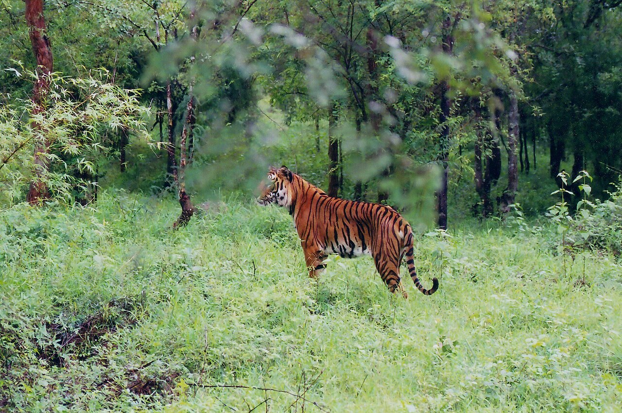
A tiger reserve on the Bhadra river around Muthodi, its dry and moist deciduous forest sheltering tigers, elephants, gaur, sambar and rich birdlife; jeep safaris run from the Muthodi range.
18.4 km · ~31 min by cab · straight line
A sacred mountain range north of Chikkamagaluru named after the Sufi saint Baba Budan, credited with first bringing coffee to India; its cave shrine (the Dattatreya Peetha) is revered by Hindus and Muslims alike, and the ridge has grassy trails and viewpoints.
32.1 km · 47 min drive
A thin, sacred cascade on the Baba Budangiri slopes where pilgrims stand in the spray, believed to have healing powers; reached by a short walk down steps from the road near the Dattatreya shrine.
32.5 km · 46 min driveA Hoysala temple of 1196 CE to Amrutesvara (Shiva) at Amruthapura in Tarikere taluk, on a star-shaped plan with a fine tower, a long inscribed hall and detailed friezes — a quieter cousin of Belur and Halebidu.
35.7 km · 42 min drive
One of the largest lakes in Karnataka, a centuries-old tank below the Baba Budan hills near Sakharayapatna, ringed by farmland and hills — a quiet birding and sunset spot.
41.4 km · 58 min drive
A calm irrigation lake ringed by coffee hills a few kilometres from Chikkamagaluru town, a popular spot for sunset views over the water with the Baba Budan range behind.
66.8 km · 71 min drive
At about 1,930 m the highest peak in Karnataka, a grassy summit of the Baba Budan range near Chikkamagaluru topped by a small Shiva shrine (Mullappa Swamy); a motorable road climbs to a saddle, from where a short stepped path leads to the top and sweeping Western Ghats views.
79.4 km · 90 min drive
The temple of goddess Sharadamba at Sringeri, seat of the Sharada Peetham — the first of the four mathas founded by Adi Shankaracharya — on the bank of the Tunga river; a major centre of learning and pilgrimage.
144.2 km · 134 min drive
A 14th-century temple in the Sringeri math complex blending Hoysala and Vijayanagara styles, famous for its twelve zodiac pillars set so that sunlight falls on the pillar of the solar month, and for its finely carved outer walls.
144.2 km · 134 min drive
A riverside temple to Adi Shakthyathmaka Annapoorneshwari, goddess of food and nourishment, at Horanadu on the Bhadra, where every pilgrim is offered a free meal; a key stop on the Sringeri–Kalasa temple circuit.
154.9 km · 142 min drive
A broad tiered waterfall of about 40 feet in forest above Kigga, 15.6 km by road from Sringeri, reached by around fifty laid steps from a car park. People bathe at the base in moderate flow, but it is loose boulders and slick rock — not a paddling pool.
159.0 km · 149 min driveWalking and driving times are real routed distances, except the few marked “straight line”, which are direct-line estimates and will read short.Routing: © openrouteservice.org by HeiGIT | Map data © OpenStreetMap contributors
Karnataka Tourism describes a drop of about 45 metres from the Chandra Drona hills.
The state tourism department places the falls about 10 km from Kemmanagundi and 53 km from Chikkamagaluru.
It is the Veerabhadreshwara Temple, a living Shiva shrine attributed by Karnataka Tourism to the Vijayanagara period.
Post-monsoon months usually give stronger flow with more manageable conditions than peak rain. Conditions change quickly, so avoid entering the water during heavy flow.
No continuous step-free route is documented. Expect wet, uneven surfaces around the temple and cascade; travellers with limited mobility should ask a local contact about the day’s closest safe drop-off point.
July to December for full flow; combine with Kemmanagundi.
Entry: No verified visitor fee. Timings: Temple reported 6:00 AM–6:00 PM by Karnataka Tourism; confirm locally.
Near Kemmanagundi, ~55 km from Chikkamagaluru; reach it by road/taxi and a short walk of steps. A temple site — footwear off near the shrine; the steps and rocks are slippery when wet.
45 minutes to an hour.
Nearby you can pair Bhadra Wildlife Sanctuary (18.4 km), Baba Budangiri (32.1 km), Manikyadhara Falls (32.5 km), Amrutesvara Temple, Amruthapura (35.7 km).
Written about Kalhattigiri Falls itself — its history, its legends and the arguments about them.

These guides explore Kemmanagundi and the surrounding area. Choose a visit that fits your interests, allowing separately for travel between stops.


Written about Kemmanagundi as a whole rather than about Kalhattigiri Falls — its history, its streets, and how to spend a day in it.


Route-level itineraries and practical guides for the rest of Karnataka.
Photographs: Vinayak Kulkarni, CC BY-SA 3.0, via Wikimedia Commons (CC BY-SA 3.0). Wikimedia Commons.


