Places to Visit in Ranipuram

Grassland hill and short trek area on the Western Ghats edge.

Ranipuram
Practical guide

Plan Ranipuram

Who's going?Tailor Ranipuram to your trip
DistrictKasaragod
RoleHill base
Time neededHalf a day covers the drive up, the walk…
Places to visit2Listed businesses6

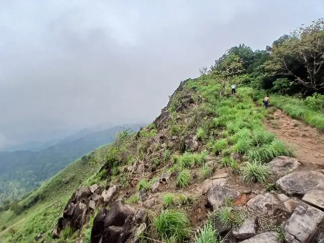
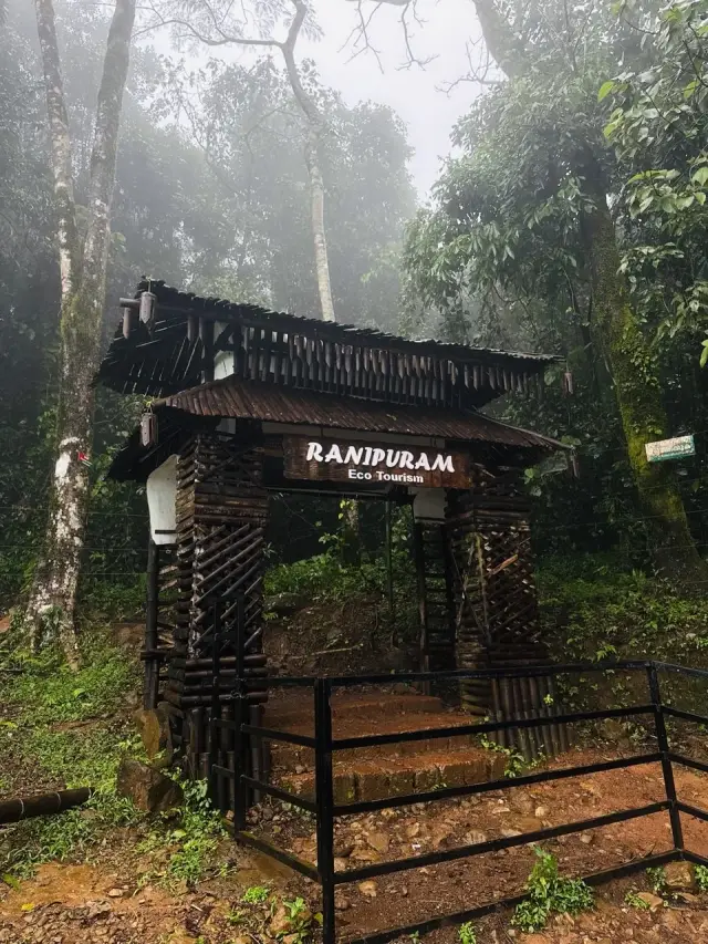
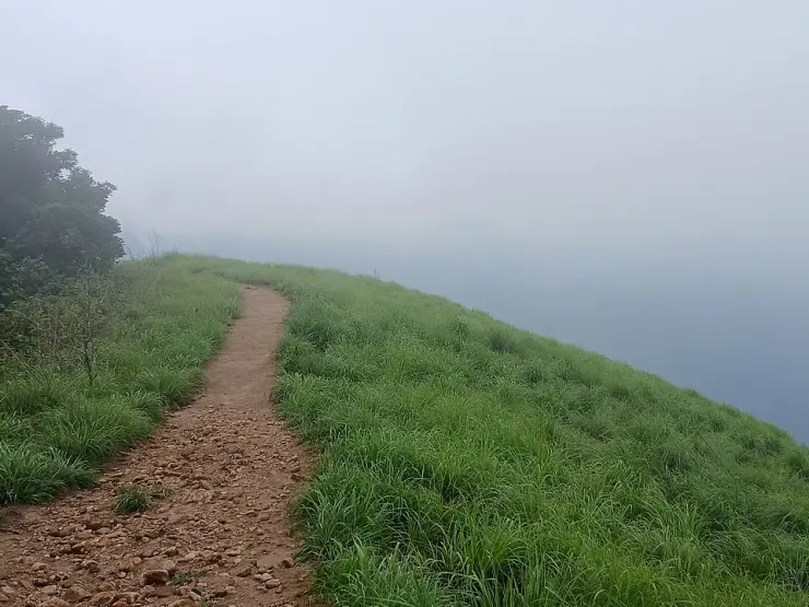
Ranipuram is a grassland hill on the Karnataka border in eastern Kasaragod, and the walking is the whole point of it. A path climbs from the eco-tourism gate through evergreen shola forest and comes out on open grass and moorland; Kerala Tourism describes a two-kilometre walk through forest before the grasslands open, and the full return route is about five kilometres. Wild elephants use these hills, so the forest office controls access and the walk is done with that in mind rather than on a whim.

Two things are worth knowing before you read anything else about the place. The elevation is quoted three different ways — 750 m, 780 m and 1,048 m — because the first two describe the base and the third the summit, and they are not in conflict. And the name is barely fifty-five years old: this hill was Madathumala until 1970, when families resettled here renamed it. There is no town at Ranipuram in the ordinary sense, no market street and no cluster of restaurants, so plan to arrive with the day already worked out.

What to expect

Highlights

  • Ranipuram — A grassland-and-shola hill topping out at 1,049 m, the “Ooty of Kerala”, with easy treks and montane forest on the Western Ghats edge.
  • Ranipuram trek — The ticketed walk up Kasaragod’s highest hill — a tarred road to a counter at about 780 m, then two kilometres on foot through shola forest into open grassland and up to the rock at 1,049 m.
  • Kottancheri Hills trek — Rainforest walking in the Kottancheri hills above Konnakad — four hills standing in a ring like a fort wall, reached on foot from the village and quite separate from the ticketed hill at Ranipuram.
Getting there

How to visit

  • Nearest airport: Kannur (CNN), ~85–95 km; Mangalore (IXE), ~60–70 km
  • Rail gateway: Kasaragod (KGQ) or Kanhangad (KZE)
Timing

Best time to visit Ranipuram

November to February, when the weather is cool, clear and pleasant, is the best window. The post-monsoon months are lush and green; trekking is usually barred in the April–June dry season owing to wildfire risk, and monsoon (June–September) brings heavy rain, slippery paths and leeches.

Weather in RanipuramSeasonal guide

Live forecast loads in your browser.

Today at Ranipuram
Sunrise6:18 am
Sunset6:27 pm
Golden hour best light5:27 pm–6:27 pm
Blue hour after sunset6:27 pm–6:52 pm
Sun sets toward compass bearingW · 272°
Moon tonight🌓 First quarter · 52%
South-west monsoon. June to September is the south-west monsoon in Kerala. Expect heavy showers, mostly in bursts rather than all day — carry rain cover, allow extra time for getting around, and note that ferries and open-air sites are the first things affected.

Sun and moon are calculated for this location and shown in IST. Photography windows are the hour around sunrise and sunset; the sunset bearing is degrees clockwise from true north. Moon phase is accurate to about half a day.

The story

The story of Ranipuram

High on the Western Ghats in the far north of Kerala, Ranipuram is a rolling world of golden grasslands, stunted evergreen shola pockets and wind-scoured monolithic rocks that locals fondly call the “Ooty of Kerala”. At its summit the district of Kasaragod runs out of higher ground, and on a clear morning the view spills across three states.

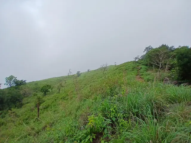
Ranipuram does not announce itself. From the quiet plantation village of Panathady you climb a bruising jeep track through cardamom and rubber, the forest closing overhead, until — quite suddenly — the trees fall away and you step onto open meadow. This abrupt handover from dense canopy to wind-blown grassland is the signature of the place, and it never quite loses its surprise.

The grasslands are dominated by lemongrass, and when the breeze moves across them the whole hillside seems to breathe. Scattered through the meadows are dark islands of shola — patches of gnarled, moss-hung evergreen forest that hunker in the folds and valleys where the wind cannot reach. Ranipuram is the only place in the whole of Kasaragod district where these ancient shola forests survive, which gives the hill an ecological rarity far out of proportion to its modest fame.

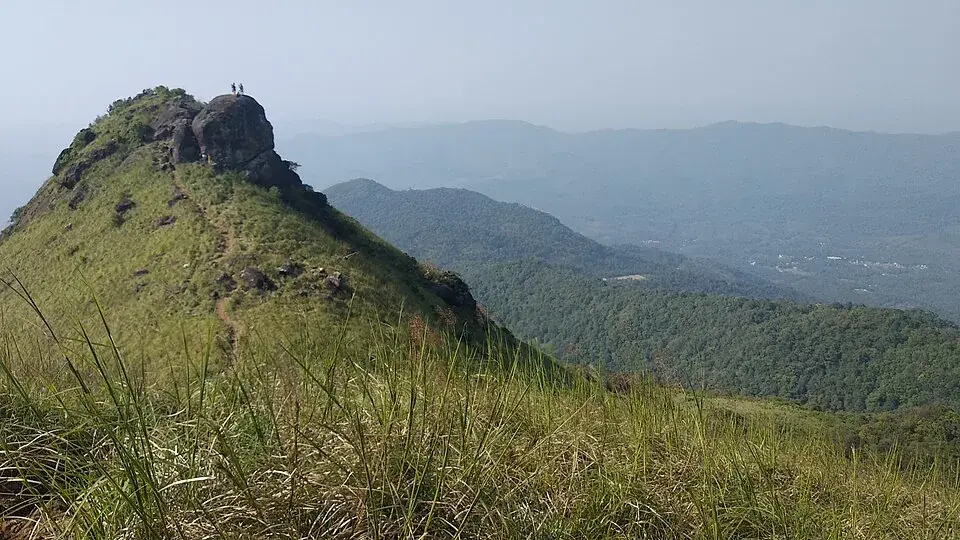
Rising from the turf are the monolithic rocks that give the summit its drama: great weathered boulders and outcrops that trekkers scramble up for the final view. The topmost point is a grass-covered crown that many visitors know simply as the “Mani” viewpoint, and reaching it is the reward at the end of the walk.

This is genuinely wild country. Ranipuram forms part of a reserve forest, and herds of wild elephants move across the slopes, following age-old paths between valley and ridge. Leopards prowl the shola edges, Malabar giant squirrels crash through the canopy, and king cobras and Russell’s vipers keep walkers watching their feet. It is a landscape to be respected rather than tamed.

For birdwatchers the hill is a quiet treasure. Surveys have recorded close to a hundred species here, among them the Malabar grey hornbill, the great Indian hornbill, the Indian black eagle wheeling over the ridgelines, the flash of an Asian paradise flycatcher and the calls of wood pigeon and peafowl drifting up from the forest.

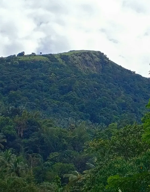
Standing at 1,048 metres, the summit is the highest point in Kasaragod district. From up here the ground drops away on every side and the panorama stretches over the ghats towards the plains — a big, uncrowded, elemental view that feels a world away from Kerala’s more famous and more trodden hill stations.

More about Ranipuram

History

For most of its history this hill was known not as Ranipuram but as Madathumala — a Malayalam name (മാടത്തുമല) that captured its characteristically undulating, hummocked terrain. Under that older name it was little more than a remote upland of grass and shola on the eastern rim of Kasaragod, grazed and traversed but barely settled.

The change came in the 1970s. The Catholic Diocese of Kottayam acquired land in these hills to resettle Knanaya Catholic families, part of the wider mid-twentieth-century migration of Christian farming communities from central Travancore into the Malabar highlands in search of cultivable land.

It was these settlers who gave the hill its present name. Devoted to the Virgin Mary — the Queen — they renamed Madathumala as Ranipuram, literally the “abode of the Queen”, in her honour. Modern tourism has since reinterpreted the name more loosely as the abode of the queen of the grasslands, but its origin lies in the Marian devotion of the migrant community.

Administratively the hill sits within Panathady panchayat in Vellarikundu taluk, and its uppermost reaches are protected as reserve forest under the Kerala Forest and Wildlife Department. That status is what preserved the shola–grassland mosaic and the elephant corridors even as the surrounding lower slopes were cleared for plantations.

Trekking here developed comparatively late and remains deliberately low-key. The Forest Department controls access from a checkpost, ticketing walkers and setting daily cut-off times, while the District Tourism Promotion Council and KTDC added simple cottages and eco-cabins at the Panathady base. The result is a hill station that has stayed small, green and refreshingly unspoilt.

Why visit

It is one of Kerala’s last genuinely uncrowded hill stations — a place where you can walk grasslands and shola forest for a whole morning and meet almost no one.

The 2.5 km trek from the forest checkpost to the grassy summit is short enough for reasonably fit first-timers yet rich enough to feel like a real Western Ghats expedition, ending with a sweeping ridge-top panorama.

The shola–grassland mosaic is ecologically unique for the district, and the monolithic summit rocks give the walk a distinctive, almost otherworldly finish.

Wildlife is close and real: wild elephants, leopards, Malabar giant squirrels and nearly a hundred bird species make this a rewarding hill for naturalists and birders.

The cool, clear northern-Malabar climate and the “Ooty of Kerala” nickname deliver the highland escape without the traffic, resorts and crowds of the better-known southern hill towns.

Its remoteness in the deep north of Kerala, close to the Karnataka border, makes it an easy, offbeat add-on to a Kasaragod or Bekal coastal trip for travellers who want somewhere the guidebooks have largely missed.
Before you go

Ranipuram — at a glance

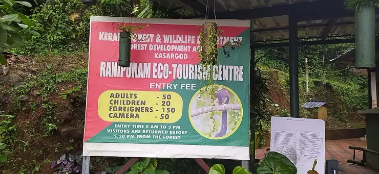
HoursThe Forest Department's board at the counter, and its own booking register, give the same window: entry from 8:00 am until 3:00 pm, and every visitor returned from the forest before 5:30 pm. Three o'clock is the last moment you can go in; half past five is when the hill is empty. Other timings circulate — Kasaragod's district tourism site publishes a 4:00 pm close and the counter is mapped as open until 5:00 pm — but the department that sells the ticket publishes 8 to 3, and that is the one to plan around.

Entry: Treat published prices as dated references, not a verified current tariff: official/reference material has carried ₹30 adult and ₹15 child, while a photographed Forest Department counter board carried ₹50 adult and ₹20 child, plus separate camera and vehicle charges. Confirm every current charge at the counter on the day and carry cash.

Festivals: Ranipuram itself is a forested hill with no temple festival calendar of its own; the nearest cultural events belong to the villages and towns of the Kasaragod plains, such as theyyam ritual-dance performances staged in the region’s shrines during the cooler months.

Photography: A photographed counter board carried a ₹50 camera charge, but that board is not a verified 2026 tariff. Confirm the current charge at the window. The grasslands and summit rock are the principal frames; under the shola canopy a fast lens is more useful than a long one.

Parking: Vehicles are left at the counter, where the road ends and the walking starts. The 9.9 km up from Panathady is tarred; it is the bends and the mist that slow it, not the surface.

Getting here

How to reach Ranipuram

  • ✈︎ By air Kannur International Airport is the nearer of the two, 105 km by road and about an hour and three quarters; Mangaluru International is 117 km. Kerala Tourism's own trek page names only Mangaluru, at 125 km.
  • 🚆︎ By train Kanhangad is the nearest station, 46 km west and about three quarters of an hour, and it is the practical arrival point. Nileshwar is further at 55 km and Cheruvattur further still at 61 km, which is the reverse of the pattern at Kottancheri on the other side of the ridge.
  • 🚗︎ By road From Kanhangad it is 46 km inland by the Kanhangad–Panathur road, then the Panathadi–Ranipuram road up to the counter. Kasaragod town is 57 km and Bekal Fort 52 km. The whole approach is tarred.
  • 🚌︎ By bus Buses run to Panathady from Kanhangad. What happens above Panathady is the one thing Kerala Tourism does not agree with itself about: its destination page says regular jeep and bus services run from Panathady and Kanhangad up to the hills, while its Bekal page says buses reach Panathady only and it is better to hire a jeep. Both are the state's own pages, so ring the counter on 8547602605 rather than trusting either.
Getting back

Check your return bus or ferry with the operator before setting out. Leave time to reach the stop or jetty after your visit, and arrange a return vehicle in advance for a remote outing.

Ask at the jetty or the stand for the time of the last service back, not the next one. If you miss it, an auto or a taxi is the fallback — agree the fare before you get in.

Do

Things to do in Ranipuram

  • Walk the track from the counter through shola forest and lemongrass grassland to the top. Official pages differ between roughly 2 km and 2.5 km, so confirm the open turnaround at the counter.
  • Climb the bare rock of Manimala Top at the end of the grass ridge, which is the high point walkers stop at.
  • Birdwatch for hornbills, the Indian black eagle, paradise flycatchers and the near-hundred species recorded here.
  • Look out (from a safe distance) for wild elephants, Malabar giant squirrels and other reserve-forest wildlife.
  • Explore the shola forest pockets — the only such stands in Kasaragod district — for ferns, orchids and mossy stream valleys.
  • Drive the Panathadi–Ranipuram road for its own sake: six hundred metres of climb in ten kilometres, through plantation country and into cloud.
  • Stay overnight in a DTPC or KTDC cottage at the Panathady base to catch dawn mist over the grasslands.
Plan

Good to know

  • The height everyone publishes for Ranipuram — 750 m, or 780 — is the counter, where the road stops and you get out. The summit is 1,049 m, the highest point in Kasaragod district, and the walk is what covers the difference.
  • Arriving at half past two buys you a march rather than a walk. Come by one at the latest.
  • Carry water up. There is nothing to buy past the counter, and the grassland stretch has no shade at all.
  • Between April and June the trail is often shut for fire risk, and in the monsoon it is leeches and slick rock. November to February is the window that works.
  • Salt or tobacco in your socks for the leeches, and long trousers. Locals will tell you the same thing.
  • Stay at Panathady if you want an early start — DTPC cottages, KTDC and a few homestays — rather than driving up from Kanhangad at dawn.
  • Mobile coverage thins out on the climb. Tell someone at the base what time you expect to be back down.
Facilities

On site

  • A Kerala Forest and Wildlife Department checkpost at the trailhead, where the ticket is issued — this is the last staffed point on the hill.
  • DTPC Kasaragod tourist cottages near Panathady, plus KTDC guest houses and private homestays and lodges.
  • Nothing to buy, no toilet and no drinking water beyond the checkpost.
  • A toilet at the counter — mapped, and the last one on the hill.
  • Kanhangad, 46 km west, is the nearest town with banks, pharmacies and a hospital.
Stay safe

Safety

  • This is reserve forest with resident wild elephants. Elephant sign on the trail means turn around, not photograph. Leopard, gaur and sambar are also present.
  • King cobra, Indian cobra, common krait and Russell’s viper are all recorded here. Watch where you put your hands on the rock steps and stay on the trail.
  • Camping on the hill is prohibited and the descent deadline is enforced. There is no lighting and no rescue on the hill after dark.
  • In the monsoon the stone-cut steps are slippery and the leeches are constant; in the dry months the trail closes at short notice for fire risk. Ring the checkpost before you drive out.
  • The approach is tarred but it is a ghat road, and in heavy rain the risk is visibility and the bends rather than the surface.
Getting around RanipuramNot wheelchair accessible
Terrain
Steep
Steps
Stone steps are laid into the track in places. Kerala Tourism describes two kilometres of walking, about an hour, from the counter to the grassland.
From the entrance
The 9.9 km up from Panathady is the Panathadi–Ranipuram road, tarred and two lanes the whole way to the counter — not the unsealed jeep track it is usually described as. Vehicles stop at the counter; everything beyond it is on foot.
Step-free access
The drive is the accessible part and it goes a long way — a tarred road to a counter at about 780 m, with a toilet. Everything above it is an unmade hill track over stone steps and open grass to a summit at 1,049 m, and there is no part of that a wheelchair user can do. We would rather say so than describe a short accessible stretch that does not exist.
Prams
No. Carry a small child or do not bring one.

A Forest Department counter at the trailhead — the last staffed point, with a toilet.No drinking water and nothing to buy beyond the counter.

  • Entry is between 8 am and 3 pm and everyone is returned from the forest before 5.30 pm.
  • Reserve forest with resident elephant, leopard and gaur, and king cobra, krait and Russell’s viper recorded. Stay on the trail.
  • Leeches and slick rock through the monsoon; the trail is often closed for fire risk between April and June.

Checked 31 August 2026 against source 1source 2source 3. Conditions change and surfaces vary with weather — if step-free access is essential, confirm with the site before you travel.

In the district

Where Ranipuram sits in Kasaragod district

District HQKasaragod
LandscapeNorthern Kerala coast, rivers, forts, hills and backwaters

Kasaragod district is known for: Bekal Fort and beach, Valiyaparamba backwaters, Ranipuram hills and north-Kerala temple traditions.

Bekal Fort & BeachValiyaparamba BackwatersRanipuram hill station
Stay · eat · do · rent · see · shop

Places in Ranipuram

Every verified place in Ranipuram — filter by what you’re after.

1 place to eat in Ranipuram

R
Ranipuram Resorts Restaurant
Where to eat
Top pick Verified
Hill resort restaurant · Ranipuram
Ranipuram Resorts Restaurant

Restaurant at Ranipuram Resorts for hill-station visitors needing food near the trekking base. Ranipuram, eat, Hill resort restaurant.

Directions Commission-freeView details

Book with the place itself. India’s cyber-crime coordination centre warned in April 2025 that convincing copies of hotel and pilgrimage booking sites are being pushed through sponsored search and social ads, taking payment for rooms the property never hears about. Every listing here links to the business’s own contact details and its own Google or Bing profile — we take no commission and sit in nobody’s payment path. If a booking page reached you through an ad, check the address bar against the property’s own site before you pay. Fraud can be reported on cybercrime.gov.in or on 1930.

Official eco & forest programmes

Forest stays, camping and treks around Ranipuram

Official/public-sector eco offerings mapped to this town base. Always confirm current availability, tariff, permits and reporting time before travelling.

Ranipuram, Ranipuram
trekviewpointwildlife

Ranipuram hill trek

One-day hill trek from the Panathady/Ranipuram side through shola, monsoon evergreen forest and grasslands.

RanipuramShort day trek
Official source →
Ranipuram, Ranipuram
forest staytrek

Ranipuram DTPC forest-base cottages

Hill-station base accommodation near the Ranipuram trek start, useful for early starts and misty grassland walks.

Ranipuramforest cottageOvernight
Official source →
For hotels, homestays and local businesses

Get listed in Ranipuram for free

Roampedia is commission-free. Travellers discover your business, book directly and contact you through official details. Basic listings are free, while Gold and Platinum package upgrades can be requested from the owner dashboard after approval.

List your business — free
Read before you go

Ranipuram guides, stories & itineraries

Stories & history of Ranipuram

Written about Ranipuram itself — its history, its legends and the arguments about them.

Around Ranipuram

The town itself and the places around it — each written about one subject rather than as a general guide.

The gate at Ranipuram, and what it actually costs
Kasaragod · Ranipuram
The gate at Ranipuram, and what it actually costs

Fifty rupees, eight in the morning until three in the afternoon, everybody out of the forest by half past five — and nearly a thousand tickets a day, so the queue is not the thing to worry about.

4 min read · Read →
At Ranipuram, the road does most of the climbing
Kasaragod · Ranipuram
At Ranipuram, the road does most of the climbing

The figure printed on almost every page about Ranipuram is where you park. The hill goes on for another two hundred and seventy metres above it, and that is the part you walk.

4 min read · Read →
Grassland, shola and leeches: what Ranipuram actually is
Kasaragod · Ranipuram
Grassland, shola and leeches: what Ranipuram actually is

Rounded islands of dark wet forest sitting in open grass: this is the only place in the district where that happens, and it is worth understanding before you photograph it.

4 min read · Read →
Kottancheri: the four hills that make a fort
Kasaragod · story
Kottancheri: the four hills that make a fort

Kotta is Malayalam for a fort, and the four hills above Konnakad stand in the shape of one. On top of Kumban mala a stone wall runs along the ridge, and it is the line between two states.

5 min read · Read →
Trekking Kottancheri: the permission, the guide and the day
Kasaragod · guide
Trekking Kottancheri: the permission, the guide and the day

No gate, no counter, no board and no path. Kottancheri is reserved forest, and the arrangement has to be made before you leave, not when you arrive.

5 min read · Read →
What lives in the Kottancheri forest
Kasaragod · story
What lives in the Kottancheri forest

A single naturalist walked these ridges for one day in October 2025 and left more than seventy photographs. What they show is not scenery — it is a rainforest working.

5 min read · Read →

Planning a trip to Ranipuram

The practical half — what is actually here, in what order to see it, and how to arrive.

Kerala-wide guides & itineraries

Route-level itineraries and practical guides for the rest of the state.

See all 29 Kasaragod guides & stories →

Map

Where things are in Ranipuram

FAQ

Ranipuram travel FAQs

Why is Ranipuram called the “Ooty of Kerala”?

Because of its cool climate, rolling grasslands, shola forests and elevated ridge-top views, which draw comparison with the famous Nilgiri hill town of Ooty. Ranipuram is far smaller and quieter, but the highland scenery earns it the nickname.

How high is Ranipuram and is it really the highest point in Kasaragod?

The base of the hill sits at around 750 metres, while the summit reaches roughly 1,048 metres — making it the highest point in Kasaragod district. Confirm the exact trail conditions locally before you set out.

What was Ranipuram called before?

It was known as Madathumala, a Malayalam name reflecting its undulating terrain. It was renamed Ranipuram in the 1970s by Knanaya Catholic settlers in honour of the Virgin Mary, the Queen.

Do I need a permit or a guide to trek Ranipuram?

Access is controlled by the Kerala Forest and Wildlife Department. You buy an entry ticket at the checkpost, and hiring or being accompanied by a forest guide is advisable; specific guide requirements are best confirmed at the checkpost on the day.

How long is the trek and how difficult is it?

The main trail runs about 2.5 km one way from the forest checkpost to the grassy summit — roughly a 5 km return walk through forest and open meadow. It is moderate rather than strenuous and suits reasonably fit walkers, though the initial forest stretch can be steep.

When is trekking closed at Ranipuram?

Trekking is generally not permitted during the peak of summer, roughly April to June, because of wildfire risk in the dry grasslands. Daily entry also stops in the early afternoon so walkers can descend before dusk.

What are the best places to visit in Ranipuram?

Top places to visit in Ranipuram include Ranipuram trek, Kottancheri Hills trek — each has a full guide with how to reach it and what to see nearby on this page.

How do I reach Ranipuram?

The nearest airport to Ranipuram is Kannur (CNN), ~85–95 km; Mangalore (IXE), ~60–70 km. The rail gateway is Kasaragod (KGQ) or Kanhangad (KZE).

What is the best time to visit Ranipuram?

October to March is the driest and most comfortable season to visit Ranipuram and the rest of Kerala. The June–September monsoon is lush and green but wet, and often brings lower low-season prices.

Photographs: Rajeshodayanchal (CC BY-SA 4.0), Nativeplants garden (CC BY-SA 4.0), Vaikoovery (CC BY 3.0). Wikimedia Commons.

Image credits