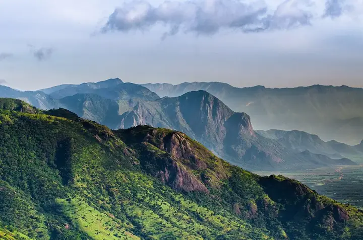
Idukki and Cheruthoni are two halves of one small hill capital, and both exist because of a narrow place in a river. The district takes its name from the Malayalam word idukku, a gorge — the pinch where the Periyar squeezes between two bare granite domes called Kuravanmala and Kurathimala. Cheruthoni is the market town in the valley, a busy one-street bazaar of lodges, shoe shops and jeep stands under a wooded ridge. Painavu is the administrative half, five kilometres uphill, where Idukki district keeps its Collectorate. Neither is a municipality: both are wards of Vazhathope grama panchayat, which makes this the smallest-feeling district headquarters in Kerala. What gives the pair their weight is what happened here — a tribal headman who showed outsiders the gorge, fifteen thousand workers who arrived to close it, a valley that went under water, and one August in 2018 when the gates finally opened.
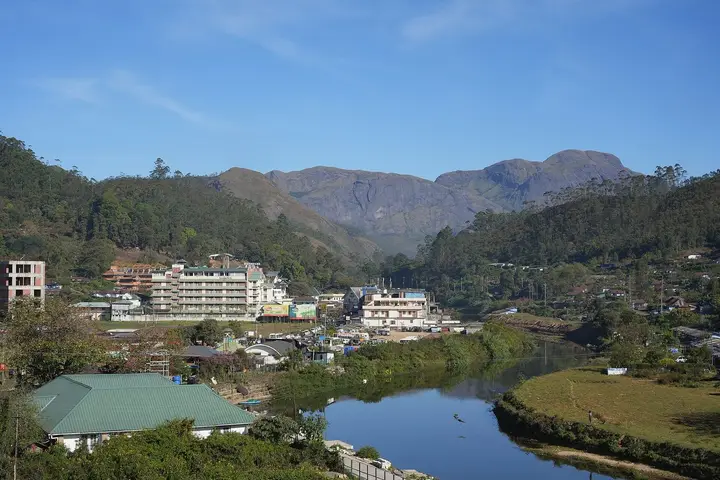
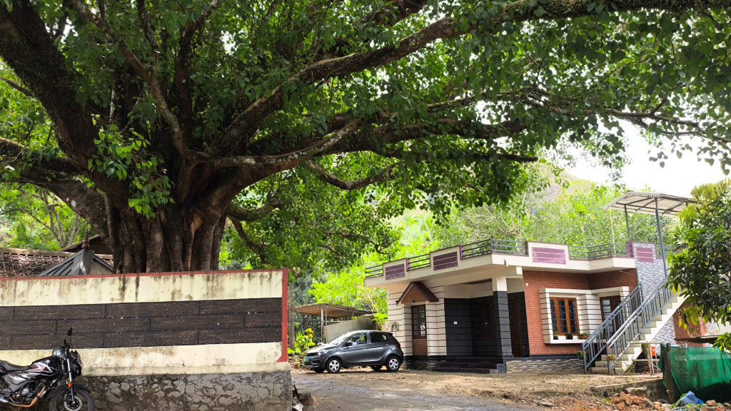
Arrive from Thodupuzha and you drop into Cheruthoni rather than approach it. The road comes off the ridge in long loops through rubber and cardamom, and then the valley opens and the town is simply there: a single busy street of three- and four-storey shophouses, tourist homes with rooftop railings, autorickshaws nosed into the kerb, and a steep forested hill closing the far end. It reads as a hill bazaar rather than a resort, because that is what it is. The Idukki taluk office, the District Industries Centre, the Kerala State Electricity Board’s offices and Idukki Medical College all sit in or near this one small settlement, and the shops are stocked for people who live here rather than for people passing through.
Five kilometres up the hill is the other half. Painavu is where the Civil Station stands, along with the Government Engineering College Idukki, a Kendriya Vidyalaya, the Model Polytechnic and the Ekalavya Model Residential School — a whole district administration parked on a wooded slope with almost no town around it. The Idukki District Tourism Promotion Council keeps its office at the Civil Station on Kuyili Mala. The arrangement is deliberate and slightly comic: the offices are up in the trees and the tea shops are down in the valley, so half of Idukki’s civil service commutes downhill for lunch.
Formally, neither place is a town at all. Kattappana and Thodupuzha are Idukki’s only two municipalities; Cheruthoni and Painavu are both wards of Vazhathope grama panchayat, a 124-square-kilometre village panchayat in Idukki taluk that also contains Karimban, Manjapara, Thadiyampad, Maniyarankudi, Peppara, Gandhinagar and the neighbouring hamlets. A district capital administered as a village ward is an unusual thing even in Kerala, and it explains a good deal about the scale of the place.
The settlement history here is short and can be dated. Through the 1940s, after famine, the government of the day opened cultivable high-range land to migrant farmers, and people came up from the lowlands and cleared forest for cardamom, pepper and rubber in the face of malaria, elephants and appalling terrain. They had been at it for barely two decades when surveyors decided that the same valleys made the finest reservoir basin in south India. Much of what those settlers cleared is now under the water you photograph from Hill View Park.
Then came the workers. The Kerala State Electricity Board took the project on, Hindustan Construction Company won the build, and Cheruthoni turned into a construction town almost overnight. Around fifteen thousand people worked on the first phase, and eighty-five of them died on the job. HCC’s workforce was drawn from most states of north India as well as from Kerala, and through the 1960s a visible part of Cheruthoni’s population was Sikh, come down from Punjab for the dam. Tamil wage labourers who arrived for the same work stayed on and never left. That mixture is still audible in the street, and it is the real reason a village ward in the High Range has a market this size.
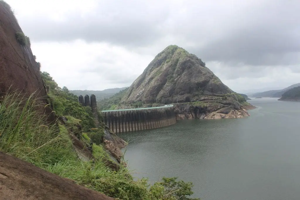
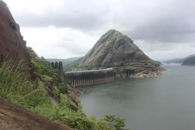
Everything the visitor actually does here happens at Vellappara, on the shoulder between the two settlements. The DTPC runs its Hill View Park there, looking east down the reservoir to the thin white line of the arch dam crest strung between the two granite hills. The reservoir boats also start from Vellappara, working the water below the dams. Kalvari Mount, the cross-topped pilgrim viewpoint, is about thirteen kilometres away. And on the same slope, facing the dams, is the grave of the man who showed the gorge to the people who built them.
That man was Chemban Kolumban — Karuvellayan Chemban Kolumban in full — headman of the Oorali community, whose settlement stood at Narikkad in Chembacheri, roughly five kilometres from where the arch dam now stands. He was taken on as a guide by a hunting party from the Malankara estate, and it was Kolumban who led them to the gorge and told them the legend attached to the two hills. He lived long enough to see the project begin but not to see it finish: he died on 21 June 1970, at a reported 112 years of age, six years before the scheme was commissioned. He was honoured at the early ceremonies and received as a guest when the Canadian side took up the works.
What the town has done with his memory since is worth knowing. A statue of Kolumban was raised beside the dam in 1976, by the sculptor Kunnuvila Murali; at the dam park a colossal grey head-and-shoulders figure of him now forms the archway you walk under to start the path uphill, weeds growing out of his hair. His samadhi at Vellappara was rebuilt as a public memorial by the Kerala government — work began in 2015 and it opened to visitors in 2020, with the same sculptor commissioned again. It is a low stepped stone plinth on a brick-paved court, a plaque in Malayalam reading Chemban Kolumban Samadhi, and a concrete elephant standing in the trees above it. Almost nobody who comes for the dam goes and looks at it.
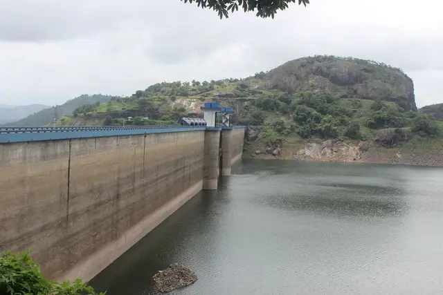
The other date the town measures itself by is 9 August 2018. The Idukki reservoir has no spillway of its own — the arch dam has no shutters at all — so when the water has to go, it goes through the five radial gates of the Cheruthoni dam, into the Cheruthoni river, straight past this street. Before 2018 that had happened twice: from 29 October to 13 November 1981, and for twelve days from 12 to 23 October 1992, both times in the north-east monsoon. On the morning of 9 August 2018 the first shutter went up in a south-west monsoon for the first time ever, and within about twenty-six hours all five were open, with the level past 2,400 feet, sending roughly 750 cumecs downstream. On 15 August the gates were opened further, to about 1,000 cumecs, as water also came down from Mullaperiyar. The shutters stayed up until 7 September. Parts of Cheruthoni were inundated and the release added to catastrophic flooding all the way down the Periyar.
It is worth being straight about the argument that followed, because the town lives inside it. The Central Water Commission’s later analysis found the Idukki and Idamalayar releases were controlled, stayed well below the dams’ maximum discharge capacity, and moderated rather than worsened the flood; independent modelling from IIT Madras, Purdue and IIT Gandhinagar reached broadly the same conclusion. Against that, a report by Adv. Jacob P. Alex, an advisor appointed by the Kerala High Court, alleged that reservoir operators had been managing for storage rather than for flood cushion and that alerts and evacuations were not handled to the emergency-action plan; as of August 2024 the High Court had not accepted it. Both things are on the record and a visitor standing on the Cheruthoni bridge should know both.
Legend & myth
Start with the two words, because the legend is really a piece of toponymy. A kuravan is a man of the Kurava community and a kurathi is his wife; mala is a hill. The two hills that grip the gorge are Kuravanmala, at about 839 metres, and Kurathimala, at about 925 metres, and the Periyar runs in the slot between them. That slot is the whole reason this district has its name: the Idukki district administration states plainly that Idukki comes from idukku, meaning a gorge. So the tribal couple of the story are not decoration attached to a dam — they are the oldest surviving explanation of why a place at the top of Kerala is called what it is called.
The famous version of the tale is the Ramayana one, and this record deliberately leaves it where it already lives. In that telling Kuravan and Kurathi glimpsed Sita bathing in the Periyar during Rama’s forest exile, were turned to stone for it, begged not to be parted, and were promised they would one day be joined again — a promise many people locally read as kept when engineers closed the gap between the two hills. Our own pages for the Idukki arch dam and for Ramakkalmedu tell that version at length, and the enormous twin statue of the couple that everyone photographs is not here at all: it stands on the windy ridge at Ramakkalmedu, sculpted by C. B. Jinan and raised in 2005, a long drive away in the south-east of the district. Coming to Cheruthoni expecting to find it is one of the commonest mistakes made about this place.
The older and much less-repeated strand is worth having instead, and it changes the register completely. Malayalam sources record a tradition that Parvati and Shiva were once born into the world as Kurathi and Kuravan. On that reading the couple in the gorge are not trespassers under a curse but gods walking about in tribal skin, which is a very different theology and a much more Kerala one — the divine turning up disguised as the people at the bottom of the social order rather than punishing them.
That fits what Kurathi actually is in Kerala’s folk religion, which few visitors realise. She is not only a character in one dam story. Kurathi is venerated as a deity in her own right alongside hill figures such as Muthappan, Pottan and Gulikan; she walks into Theyyam as Kurathi Theyyam, into Padayani, and into the Porattu Nadakam folk plays; and Kurathiyattam, the Kurathi’s dance, is named for her. In the legend of the Arakkal Devi temple in Kollam it is a Kurathi who gives the goddess water to drink, and the pollution that follows is why the goddess settles there. In other words the woman in the gorge belongs to a large, living devotional tradition that has nothing to do with hydroelectricity, and the two hills borrowed her, not the other way round.
Now the evidential status, stated flatly. None of this is history. No Ramayana text names Kuravanmala or Kurathimala, the Sita-bathing episode is not in Valmiki or in the Malayalam Adhyatma Ramayanam, and there is no archaeology here to test. It is oral tradition, and it is unusually easy to catch changing: the coda in which the cursed couple are reunited by the building of the dam cannot possibly be older than 1969, when construction started. That makes this one of the very few Kerala legends whose most-quoted ending can be dated to within a decade — a folk story that grew a new final act in living memory, and a useful warning about how quickly a tradition can absorb a piece of engineering and then present it as ancient.
There is one point at which the legend genuinely enters the documentary record, and it is the best thing about it. When the Oorali headman Chemban Kolumban led the hunting party from the Malankara estate through this forest, what he gave them was not a survey — it was the story. Both the English and the district administration’s own accounts say he told them the legend of the Kuravan and Kurathi hills, and that it was on hearing it, and then seeing the water tearing through the gap, that A. C. Thomas Edattu said the place would take an arch dam. Whatever one thinks of the tale, it is on the record as the finding aid. The folklore is the reason anyone looked.
Kolumban’s own community has ritual life of its own, and it is worth naming rather than flattening into a single anecdote about a dam. The Ooralis perform Ooralikkoothu — a form done when forest is cleared, when land is prepared, at sowing and at harvest, at funerals, and at the ear-piercing and coming-of-age rites. It is a working ritual calendar tied to the agricultural year, not a stage art. The Oorali novelist Pushpamma, herself of the community, wrote Kolukkan about that life. One thing to refuse clearly: the well-known Kalleli Oorali Appooppan Kavu, where Ooralis alone perform the pooja, is at Konni in Pathanamthitta district and belongs to that place, not to this one — our Konni record covers it.
A last honest blank. Cheruthoni is a transparent Malayalam compound — cheru, small, and thoni, a dugout canoe — and it names the river before it named the town or the dam. What no source consulted here could tell us is why: whether a small canoe crossing worked this stream, or the name means something else entirely. Kerala place names attract confident explanations invented after the fact, and rather than supply one, this record leaves the question where it found it, open.
More about Idukki and Cheruthoni
History
The gorge was noticed long before anyone could do anything about it. A report proposing a dam for power generation here was submitted to the Travancore government as early as 1919, credited to an Italian engineer named Jacob, and rejected. The encounter that mattered came next, and its date is genuinely disputed: English-language accounts and the Idukki district administration place Kolumban’s meeting with the Malankara estate superintendent W. J. John and his friend A. C. Thomas Edattu in 1922, while the Malayalam Wikipedia articles on the dam and on Kolumban himself date the hunting trip to 1932. Both agree that W. J. John, working with his engineer brother, submitted a report to the Government of Travancore in 1932 on the possibility of damming the Periyar at Idukki. This record prints both dates rather than choosing.
After that the file moved at the pace of a colonial administration. K. A. Narayana Pillai raised the scheme in the Travancore assembly in 1935. The Italian engineers Angelo Omedayo and Clantheyo Masele produced a favourable study in 1937 and nothing came of it. P. Joseph John, Chief Electrical Engineer to the Travancore government, submitted a preliminary investigation in 1947. The Central Water Commission carried out a detailed investigation in 1956, the project report was written in 1961, the Planning Commission sanctioned the scheme in 1963, and preliminary works began in 1964 under the Superintending Engineer E. U. Philipose. Forty-five years passed between the first proposal and the first spade.
Construction started on 30 April 1969. Dr D. Babu Paul, IAS, was appointed Project Coordinator and District Collector, working with KSEB engineers including C. V. Mathews and M. Ramachandran. The Government of Canada backed the scheme with long-term loans and grants; the Canadian consulting firm SNC advised, and Hindustan Construction Company, of the Walchand group, executed the build. The Canadian money reached down to the machinery: the Pelton turbines came from Neyrpic Canada and Dominion Canada, the generators for the first three units from GE Canada and for the second three from MIL Canada. Storage in the reservoir began in February 1973.
There are three dams, and they do three different jobs. The arch dam closes the Periyar gorge itself and has no gates. The Cheruthoni dam — 138 metres of concrete gravity, the largest and highest gravity dam in Kerala — stands a kilometre west and carries the spillway for the whole reservoir. The Kulamavu dam, 385 metres long and 100 metres high, plugs the Kilivallithodu in Arakkulam so the impounded water cannot escape down that rivulet; it too has no spillway, and it was completed in 1977. Together they hold a single lake of about 60 square kilometres at a full reservoir level of 2,403 feet. Seven diversion dams and weirs — Azhutha, Vazhikkadavu, Kuttiyar, Vadakkeppuzha, Kallar, Erattayar and Narakakkanam — were added to feed it.
The power is generated nowhere near here. Water is taken by tunnel from near Kulamavu and dropped some 669 metres to the Moolamattom power house, dug into rock at the foot of Nadukani hill and reckoned the largest underground hydroelectric station in India, about 43 to 46 kilometres from the dam depending on which source you read. Six Pelton units of 130 MW each give an installed capacity of 780 MW and an annual output of around 2,398 million units. The first machine was commissioned on 12 February 1976 by Prime Minister Indira Gandhi, and the sixth generator only on 9 September 1986; renovation work began in 2017. The tail water is not wasted either — it goes into the Thodupuzha river and on to the Malankara scheme for irrigation in the Muvattupuzha valley. Idukki district supplies roughly 66 per cent of Kerala’s power, and this is where most of it comes from.
The human accounting is thinner than it should be. Fifteen thousand people worked the first phase and eighty-five died. The settlers who had cleared these valleys in the 1940s and 1950s lost them to the reservoir. But a properly sourced figure for how many families were displaced by the impoundment, and where they were resettled, is not something this research could establish from the public record — the district and KSEB material celebrates the engineering and is close to silent on the people moved for it. That gap is stated here rather than filled with a plausible number.
Why visit
The gorge that named a district: Kuravanmala and Kurathimala, and the slot of the Periyar between them, seen whole from Hill View Park at Vellappara.
Chemban Kolumban’s samadhi at Vellappara — the memorial to the Oorali headman who showed outsiders this gorge, rebuilt by the state and opened in 2020, and almost always walked past.
A working hill bazaar rather than a resort strip: Cheruthoni’s one street of lodges, shoe shops and jeep stands, with cardamom country starting at the end of it.
The oddity of a district capital that is legally a village ward — the Collectorate at Painavu, five kilometres uphill from the tea shops.
A settlement built by people from everywhere: Punjabi, north Indian, Tamil and Malayali construction families who came for the dam in the 1960s and stayed.
Boating on the Idukki reservoir from Vellappara, and Kalvari Mount about thirteen kilometres away for the long view down the drowned valley.